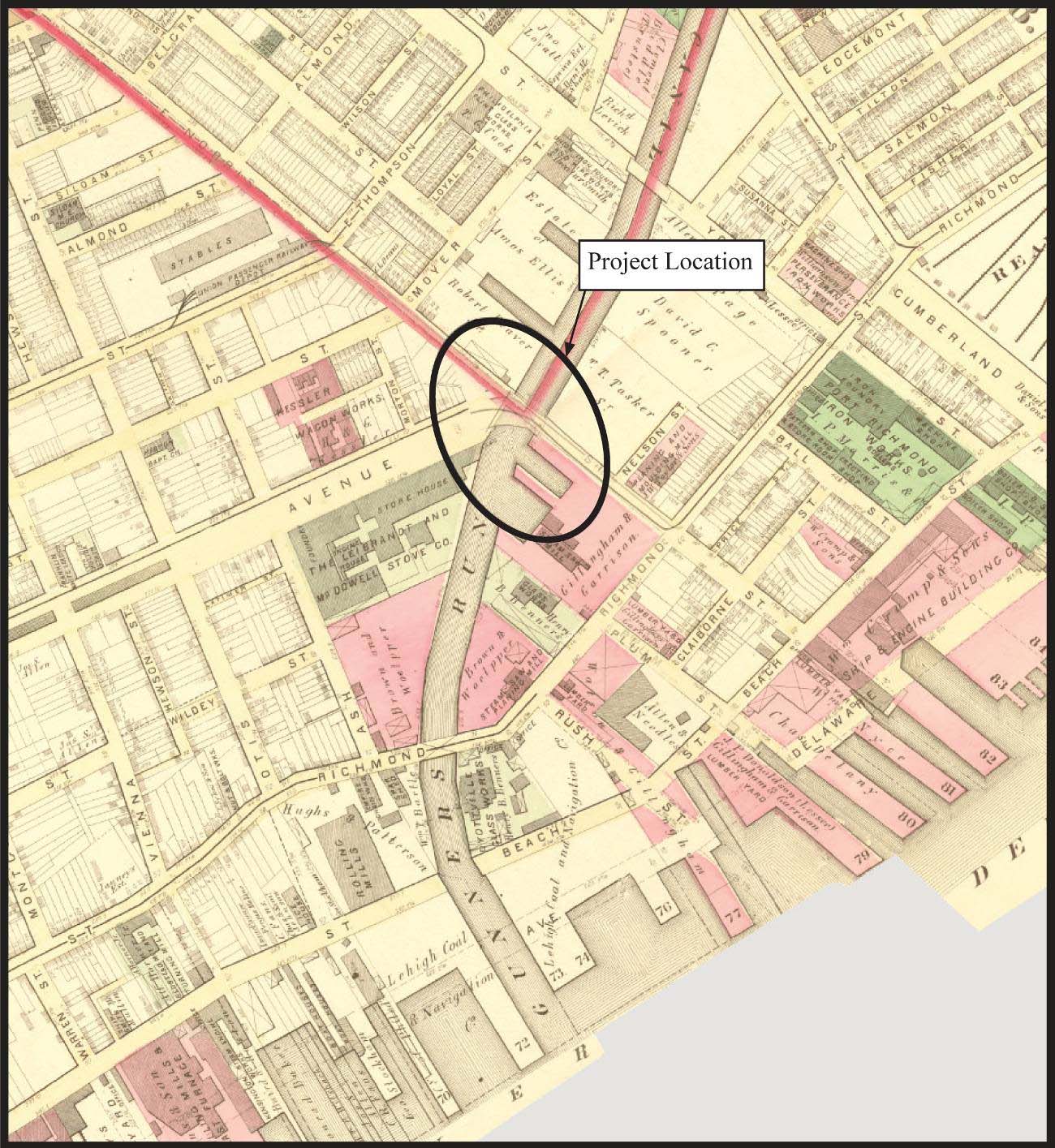
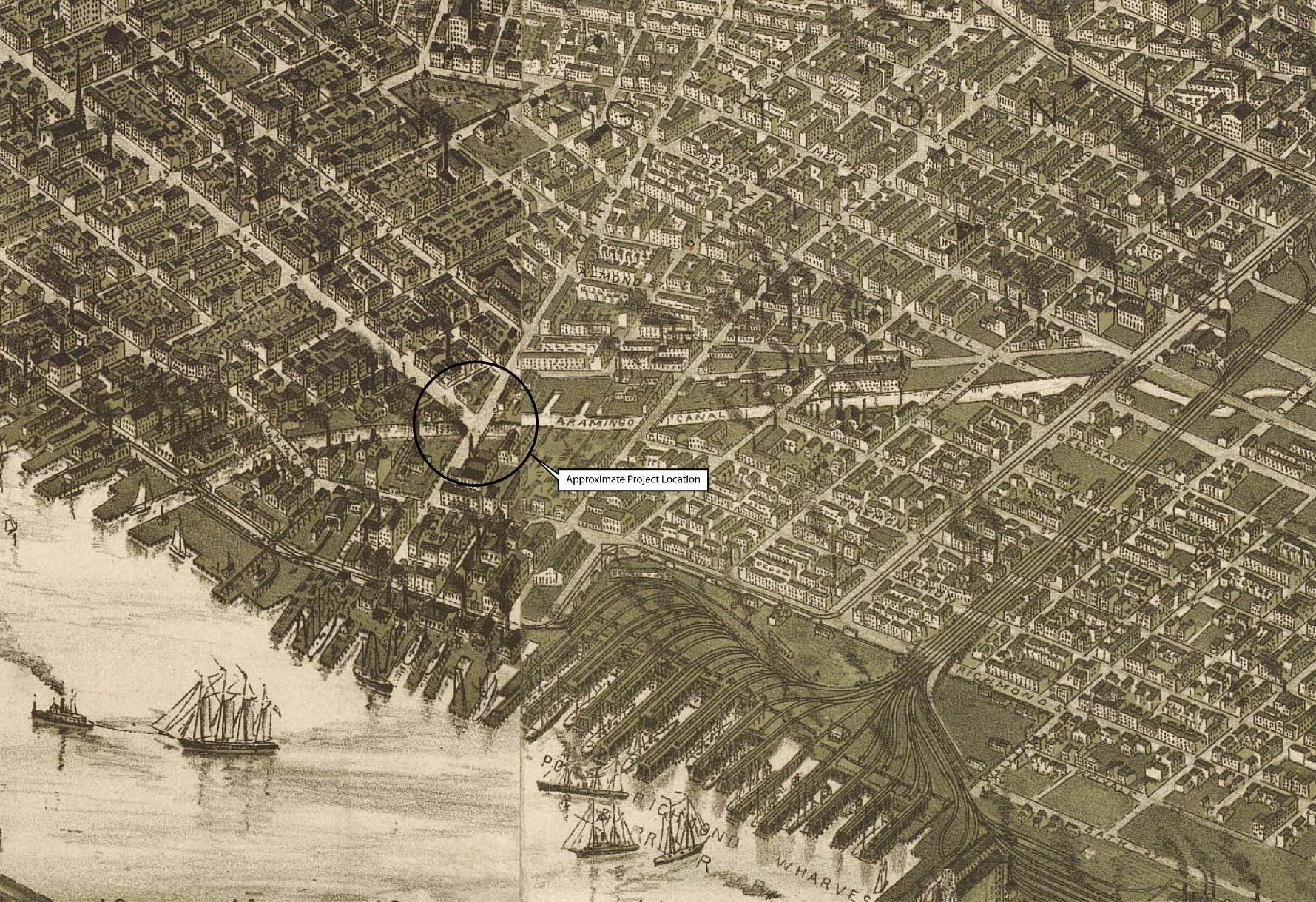
The history of the Aramingo Canal began with a meandering tidal stream located no more than three miles from the bustle and congestion of William Penn’s Philadelphia. Sometimes referred to as “Three-Mile Run,” but better known by the name “Gunner’s Run,” this stream was transformed in the mid–nineteenth century into a navigable public highway christened the Aramingo Canal. The canal was initially conceived as a means to help develop the Kensington/Port Richmond vicinity into an industrial and commercial center. The close proximity of the region to shipping facilities along Philadelphia’s Delaware River waterfront—and to the newly installed Philadelphia and Reading Railroad Company in what is now Port Richmond—was strong incentive for local businessmen and landholders who sought to increase the value of their land. Unfortunately, a lack of funding, poor management, and rapid changes in the infrastructural needs of the burgeoning community resulted in the relatively swift demise of the waterway and its ultimate removal from the visible cityscape after a period of only about 50 years.
Early History of Shackamaxon
Prior to the arrival of Europeans, the area was the ancestral home to Unami-dialect-speaking groups of Lenni-Lenape Indians. Unami, which means “the people down river,” generally refers to those Lenape peoples that inhabited New Jersey south of the Raritan River, eastern Pennsylvania as far north as Easton, and the eastern shores of Delaware 1. The Lenape living in the lower Delaware River basinwere band-level horticulturalists who lived in dispersed settlements along the river and its larger tributaries. During the early historic period, in 1656, one place within the Unami Lenape territory was identified by Swedish engineer and cartographer Peter Lindstom as a location called “Kackamensi.” Though it is not known with certainty whether this name applied to a specific settlement or to a more vaguely defined region, it was situated along the western shore of the Delaware River opposite what is today known as Petty’s Island. This place reportedly served an important function as a regular meeting place for Lenape tribal councils, and early European settlers quickly adopted its name to refer to a broad territory that today encompasses the Kensington, Fishtown, and Port Richmond neighborhoods. Over time, the name Kackamensi was twisted through a variety of spellings to its final version, “Shackamaxon.”2
.")
Map showing the Shackamaxon Tract as it appeared before the establishment of the colony of Pennsylvania (Source: Roach 1968).
European settlement in the area began with a wave of Swedish settlers who arrived in the Delaware Valley beginning in 1637. Johan Printz, governor of the colony of New Sweden, established his capital at Tinicum Island in 1643; by the 1650s, several hundred families occupied the region 3. The land in and around Shackamaxon was first patented to a man named Peter Larsson Cock on June 5, 1664. When surveyed 11 years later, in 1675, the “Shackamaxon Tract,” as it was then known, included some 1,600 acres and encompassed an area along the west bank of the Delaware River lying to the north of a stream called Cohocksink Creek (present-day Canal Street) and south of Frankford Creek (Figure 2.1). At that time, the tract was occupied by the families of six men: Lasse Cock (son of Peter), Michael Nilsson Lyckan, Peter Nilsson Lyckan, Eric Cock, Otto Ernest Cock, and Gunnar Rambo 4.
Of these individuals, the last named was the son of Peter Gunnarsson Rambo, who had arrived in the Delaware Valley aboard the Swedish merchant ship Kalmar Nyckel in 1640 5. His son, Gunnar Rambo, eventually married a daughter of Peter Cock and acquired a parcel of land within the Shackamaxon Tract bordering a small, meandering tidal stream known by the Lenape name “Tumanaraming” Creek (Figure 2.2). Over time, this stream came to gain widespread recognition through its associated with Rambo’s land, and became widely known as “Gunner’s Run.”
In March 1681, King Charles II of England issued a land grant of 45,000 square miles, later known as Pennsylvania, to William Penn, a Quaker. Upon Penn’s arrival to his new land in 1682, the only settlement within the boundaries of present-day
.")
Project area vicinity in 1681 (Source: Holme 1681).
Philadelphia was the Swedish settlement of Wicaco, which consisted of a handful of log houses and a log blockhouse built in the Scandinavian style 6. Penn’s plans to create a “greene country towne” were somewhat compromised with the discovery that the Swedes already owned much of the riverfront he had hoped to incorporate into his Philadelphia. Purchase of these parcels depleted Penn’s finances considerably and resulted in a downsized settlement plan of 12,000 acres organized in a grid pattern of streets with five public squares. The boundaries were between South and Vine Streets and the Delaware and Schuylkill Rivers, with the most heavily developed portion of the city concentrated along High (Market) Street east of Fourth Street 7.
William Penn’s assistant surveyor of the county of Philadelphia was Thomas Fairman 8 and, by 1702, much of the Shackamaxon Tract had transferred to Fairman’s ownership. The land included 300 acres that his wife, Elizabeth Kinsey, purchased in 1678 from Captain Lawrence Cock, chief translator for William Penn 9, prior to her marriage to Fairman in 1680 10. By 1729, ownership of Fairman’s land had transferred to Robert Worthington, an innkeeper, and included 191.5 acres to the south of Gunner’s Run with a manor house on the northwest corner of Beach Street and Columbia Avenue. When the land became available, Anthony Palmer, a merchant from the West Indies and owner of the adjacent Hope Farm estate, sought to make purchase. To secure the funding, Palmer sold Hope Farm to William Ball in April 1729 for £2,140 Pennsylvania currency. Included in the purchase price were 676 acres of land, meadow, and swamp beginning at the mouth of Gunner’s Run.
.")
Project area vicinity in 1802 (Source: Varle 1802, image courtesy of the David Rumsey Map Collection).
In January 1730, Palmer purchased the former Fairman estate and named the tract “Kensington,” after England’s Kensington Palace. Palmer’s lifestyle exhibited traces of refinement, and perhaps excess, but his business acumen was a great aid in the growth of the area. In an effort to attract settlement, he subdivided his holdings into smaller lots and founded the village named after his estate (Figure 2.3). Among the primary respondents to his offer were shipbuilders, who by the mid–eighteenth century were having trouble finding suitable locations within the city due to the cliffs along the shoreline and the commerce of the port 11. The Kensington riverfront also attracted fishermen, who settled in the area around Gunner’s Run and developed a livelihood centered on the shad runs up the Delaware River. The present-day name “Fishtown” is a result of their presence 12.
Next door, at the former Hope Farm, William Ball erected a grand home on his newly acquired land, which he renamed “Richmond Hall.” In subsequent years, the wider area encompassing Ball’s estate would be known as “Richmond” or the “Richmond Precinct,” and in the nineteenth century became the neighborhood of Port Richmond. In a circa-1753 survey of his estate (Figure 2.4), Ball’s “Mansion” appears on the banks of the Delaware River, to the east of “Point No Point Road” (present-day Richmond Street). Ball died 10 years after purchasing Hope Farm and left behind five children, the eldest of whom, William Jr., inherited most of the land. While much of the land contained within the Richmond Hall estate was submerged beneath the Delaware River with each high tide 13, there was still an interest in industrial development. In 1771, Robert Towars and Joseph Leacock rented from Ball “a piece of ground on the east side of Bank Street one hundred feet front and extending to the river.” They established the successful Philadelphia Glassworks, which Thomas Dyott later purchased in the early nineteenth century and made famous under his own name 14.
.")
Manuscript survey of lands comprising the William Ball estate (Source: Grover circa 1753).
In another development, Benjamin Franklin, a cousin of Leacock by marriage 15, invited a man named John Hewson to relocate from England to Kensington to avoid the wrath of King George for his revolutionary political views. Hewson accepted the offer, left England in 1773, and established a calico printing works at Gunner’s Run near Point No Point Road the following year 16. With clientele such as Martha Washington, who favored Hewson’s prints and went so far as to commission a kerchief for her husband, the area was bound to grow and did so steadily 17. Hewson, a soldier as well as a businessman, returned from the Revolutionary War a hero and ran the company until retirement in 1810, when his son John Hewson Jr. took over the business 18.
.")
Project area vicinity in 1808 (Source: Hills 1808).
The establishment of these early industries along the north shore of Gunner’s Run during the latter eighteenth century gave rise to a small independent community that called itself “Balltown.” Likely consisting of no more than a smattering of simple homes, and populated primarily with individuals and families employed in the adjacent glassworks and calico printing house, this community was established by the late eighteenth century and identified on maps in the early nineteenth century (Figure 2.5). By the 1830s, however, this little hamlet had been subsumed by the Dyottville settlement established around Dr. Thomas Dyott’s glassworks. During its brief lifetime, Balltown represented the northernmost extent of development in the vicinity of Gunner’s Run. To the north and west, the Fairhill and Sepviva estates of the Norris family remained private residential property and farmland into the mid–nineteenth century 19.
Industrial and Commercial Growth
.")
Sketch of the stone Richmond Street Bridge over Gunner’s Run, constructed circa 1834. A larger iron bridge replaced this bridge in 1853 (Source: Philadelphia City Archives 1853).
As Kensington thrived and industry expanded on Ball’s land, there was a need for infrastructural improvements. While bridges across Gunner’s Run are recorded as early as 1683 20, the concentration of industry at Point No Point, near the intersection of that stream and the Delaware River, warranted the construction of “a fine substantial bridge” by December 1834 21. It is likely that heavy traffic moved through this area due to the presence of the Dyottville Glassworks. There was some speculation that financial contributions from the glassworks resulted in expedited and enhanced construction, with this bridge having been built with higher walls and fencing than most 22. The elaborate design of this bridge is depicted in a pen-and-ink sketch accompanying the petition for the construction of a later (1853) steel bridge across Gunner’s Run (Figure 2.6).
Thomas Dyott was a self-credentialed medical doctor and nationally known salesman of patent medicines when he first rented the Kensington Glassworks from John Hewson Jr. around 1820. By the early 1830s he had purchased outright the former Kensington Glassworks and adjacent Philadelphia Glassworks, and combined them into a single complex to which he gave his own name 23. Dyott established his enterprise as a self-contained utopian community that included a school, library, chapel, store, medical facility, and housing for married couples and bachelors 24. He believed moral instruction was critical to running a successful business and allowed no alcohol consumption, gambling, fighting, or swearing among his workers or their families 25. Of his 400 employees, 130 were apprentices under the training of a handful of journeymen who agreed to Dyott’s rules of “temperance and decorum” 26. Dyott also founded his own bank, which proved to be his undoing when the Panic of 1837 revealed a lack of substance, or cash, behind his many investments 27. Convicted of fraudulent insolvency, he was sentenced to three years in Eastern State Penitentiary. He was then pardoned, rearrested as a debtor, and served the remainder of his term at Moyamensing Prison. Lehigh Coal and Navigation bought a large portion of Dyott’s former glassworks property and leased it to later glassmakers, who kept the Dyottville name until the factory closed in 1923 28.
While other industries in the area were perhaps not so all-encompassing or ambitious as the Dyottville Glassworks, the community was thriving. William Cramp established the Cramp shipyard as a producer of wooden vessels in 1830 with funding from his family’s shad fishery. At that time, at least 12 other shipyards were operating on the riverfront. Cramp’s original site, founded at the foot of what is now Susquehanna Avenue, employed less than 100 men and soon moved to Palmer Street. With the transition from wood to iron hull construction methods around the time of the Civil War, Cramp not only survived but thrived. In 1863, their first iron-hulled vessel was built, and by 1870, wood construction was abandoned altogether 29. By 1872, the company incorporated to become William Cramp and Sons Ship and Engine Building Company 30, and in doing so took over operation of the I. P. Morris Company, a machine-building establishment founded in 1828 31. Cramp remained in operation through World War I and went idle in approximately 1927. In 1940, with $22,000,000 contributed by the Navy, Cramp shipbuilding reopened to fabricate light cruisers and submarines. The facility closed permanently after World War II 32.
.")
Project area vicinity in 1843 (Source: Ellet 1843).
Following the advent of steam power in the 1830s, the landscape of Philadelphia and the surrounding region generally—and of Kensington, Richmond, and Northern Liberties in particular—underwent radical change as the Industrial Revolution gained momentum. A steam-powered sawmill was established at Beach and Hanover Streets, supplying, among other things, lumber for Cramp’s clipper ships 33. The Penn Steam Engine and Boiler Works, founded by Thomas Reaney and Jacob Neafie on Beach Street, manufactured boilers and engines as early as 1838 34—and in later years, as Reany and Neafie, then Neafie and Levy, branched out to iron boats, propellers, fittings, and brass and iron castings for marine use 35. Steam engines, both stationary and portable, were a leading item of production, and great effort was made to simplify and streamline design to speed production and reduce cost 36.
By the 1840s, Kensington’s street grid was filled out with new residents and businesses, and the waterfront was built up with wharves, both private and public. According to city directories from the time, fully half or more of the occupants of Kensington worked in an industry related to fishing or shipbuilding 37. So expansive was the growth that Kensington, formerly a part of Northern Liberties, was incorporated as an independent district in March 1820, and maintained self-rule until the city of Philadelphia consolidated in 1854 38. The boundary of Kensington by this time extended as far as Germantown Avenue to the west and Lehigh Avenue to the north 39. A map of the area in 1843 shows the extent of development in Kensington, but indicates the presence of only a few factories east of Gunner’s Run (Figure 2.7). These factories included the Pennsylvania White Lead Works, a cordage factory, and a rope works and chemical works along Point No Point Road in Richmond 40. Of the 258,037 inhabitants listed in Philadelphia County, 22,314 were in Kensington and 34,474 were in Northern Liberties, compared to 93,665 in the city of Philadelphia.
Arrival of the Railroad
.")
Project area vicinity in 1847 (Source: Sidney 1847).
The establishment of what was initially little more than a modest railroad depot along the Delaware River at Port Richmond, with several wharves immediately adjacent, provided the spark that would cause the region to explode commercially. The depot was the terminus of the Philadelphia and Reading Railroad, which crossed the Philadelphia and Trenton Railroad north of Gunner’s Run (Figure 2.7). The Philadelphia and Reading Railroad had been seeking open space in order to develop rail lines to haul anthracite from the coalfields of northeastern Pennsylvania into the region, and found the space it needed in the empty marshland on Ball’s property that had discouraged earlier settlement 41. The Philadelphia and Reading’s charter was passed in 1833 and work commenced on the construction of the railroad and depot in 1835. A 54-mile-long line from Philadelphia to Reading was opened in 1838. The line was extended over time, and on January 1, 1842, the first train passed over the 93 miles of track from Richmond to Pottsville 42. In conjunction with the rail line, an extensive tidewater port facility was installed in Richmond on the Delaware River to allow movement of coal throughout the Atlantic seaboard. In 1842, the railroad transported 49,752 tons of coal to the Philadelphia waterfront, and by 1847, the tonnage had increased to 1,360,681 43.
Richmond quickly transformed into the bustling port town of Port Richmond and the surrounding 1,163 acres were incorporated as the District of Richmond on February 22, 1847 44. In 1846, some 8,953 vessels sailed out of Port Richmond, and by the following year the number increased to 11,439, with each vessel carrying an average of 120 tons of coal. With this growth, real-estate values increased rapidly. Property that sold for $10,000 in 1837 increased to $90,000 just 10 years later 45. By 1847, the once-isolated depot and wharves at Port Richmond expanded to include no less than 14 rail lines terminating along the shore (Figure 2.8). The two-by-four-block “hub” of Port Richmond had grown to encompass 10 blocks along Point No Point Road. Along Richmond Lane(Ann Street), roads ran to the shoreline, with neither marshland nor sand acting to slow development in the area.
.")
Project area in 1849, showing the proposed alignment of the future Aramingo Canal (Source: Sidney 1849).
With the construction of the rail line and port facility, there was an immediate and growing need for employees, who mostly settled in the immediate vicinity. Previously empty land surrounding Port Richmond was rapidly developed to accommodate the influx of workers relocating to find work on the shipping piers, coal depots, engine houses, workshops, and offices 46. Much of the workforce came from the Philadelphia population, and over time further reinforcements were provided in the waves of immigrants arriving at the very ports where they would soon make their living.
The switch from wood to anthracite coal as the industrial fuel of choice was of monumental importance in the redefinition of the area. With a new and seemingly unlimited fuel source in such close proximity to their foundries, ironworkers rapidly embraced and capitalized upon the use of anthracite. The Philadelphia Iron and Steel Works opened in 1844, followed by the Kensington Iron and Steel Works (1845) and the People’s Iron and Machine Works (1846). Vacated shipyards were converted to foundries and the iron rush was on 47. Other forms of manufacturing also thrived with the introduction of this new fuel. Glassworks, fabric workshops, chemical plants, and machine shops abounded in the region. The 1840 industrial census enumerates 47 factories in Kensington alone; by 1850, this number had increased to 114 48. Anthracite coal, a product that had been ridiculed years earlier, was now igniting the region with growth in roadways, train yards, and seaports 49.
By the late 1840s, the only remaining swath of undeveloped open space in the vicinity of Kensington and Port Richmond was marked by the meandering path of Gunner’s Run. The creek ran through large tracts of land owned by the Norris, Ball, and Edward estates, and for decades the surrounding marshy bottom land had effectively prevented intensive settlement and industrial growth along its banks. However, by 1847, local landowners and entrepreneurs had hatched a scheme to alter the stream from an impediment of development to a catalyst of industrial expansion. The transformative agent intended to bring about this change first appeared on the 1849 map of Philadelphia, where the alignment of a “Proposed Canal” was illustrated within the Gunner’s Run stream valley (Figure 2.9).
Gunner’s Run Improvement Company and the Aramingo Canal
The men who formed themselves into the Gunner’s Run Improvement Company, and proposed to change Gunner’s Run into a utilitarian inland waterway, devised a vision that was both extremely bold in concept and expansive in scope. Their initial plan called for the construction of a navigable canal measuring 100 feet in width and extending a total distance of some five and a half miles, from the Delaware Riverin the south to Frankford Creek in the north. The purpose of this canal was to attract new industry to the Kensington-Port Richmond area, and to supply new manufacturing ventures with means for both easily importing necessary raw materials and moving finished products to the public marketplace. According to historian John Fanning Watson, the proposed route of this canal was first surveyed as early as 1841 50, and some map views created during the 1860s and 1870s do show the full intended extent of this waterway (e.g., the Index Plate of Smedley’s 1862 Atlas of the City of Philadelphia). Unfortunately, the scope of this project ultimately proved to be too ambitious, and a number of factors conspired to prevent the project from ever becoming fully realized. Despite the canal’s numerous shortcomings, it did play an important and, for a time, successful role in revolutionizing the commercial and industrial composition of the surrounding neighborhoods.
On March 15, 1847, through an act of the state assembly, the Gunner’s Run Improvement Company was incorporated for the purpose of improving the creek through the construction of a canal that could be used to transport goods within and beyond the immediate vicinity of Kensington 51. Fifty-two individuals were appointed commissioners of the new company (Table 2.1), including several men who were immediately recognizable members of old Kensington families, such as Abraham P. Eyre, Samuel Norris, George Ball, William Emlen, Peter Rambo, and Richard Eyre. Historic records indicate that the commissioners came from a variety of professional backgrounds and included many merchants and carpenters, as well as innkeepers and politicians 52. Present in lesser numbers were manufacturers, fishermen, shipbuilders, one lumberyard owner, one physician, one conveyancer, one broker, and one “gentleman.” The majority of commissioners lived in Kensington, with others coming from Northern Liberties, Bridesburg, and Richmond. Most lived or did business in the immediate area and all were seeking to continue the growth the railroad initially spurred.
The act creating the Gunner’s Run Improvement Company, written in 19 sections, enumerated the conditions under which the corporation was to operate, and it clearly stated that the authority of Kensington would always override that of the improvement company (see Appendix A). The act also specified that the company was to construct a canal that extended from the Delaware River to the intersection of the Philadelphia and Reading Railroad and Gunner’s Run (between Lehigh and Somerset Streets). From Queen (Richmond) Street to its northern terminus, the canal was to be not more than 100 feet in width; however, the lower section, from Queen Street to the Delaware River, was limited to a maximum 60-foot width. Property owners adjoining the canal were given the right to build their own basins, docks, and wharves. A tide lock or tide gate was to be installed near Queen Street for the unrestricted travel of boats and rafts. The commissioners were required to construct fixed and permanent bridges at any street in the city plan with which the canal would intersect. While the act gave the company permission to build its canal, it only authorized the commissioners to take possession of and start the construction process on land along the canal route inland of Richmond Street. A subsequent act of the assembly would be required to approve the canal’s connection with the river.
Gunner’s Run Improvement Company Commissioners, 1847
| Abraham P. Eyre | Henry Hupplet | William T. Blackman |
| Samuel Norris | Edward M’Coy | Richard W. Eyre |
| George Ball | Richard Bacon | Conrad Bossard |
| Michael Barron | William Clothier | Jacob Robson |
| George T. Lewis | Joseph M. Ritterson | Thomas M. Scott |
| William J. Emlen | John Smith | Samuel Sharpless |
| John Robbins Jr. | Andrew Hague | Thomas Vaughan |
| Peter Rambo | Samuel T. Bodine | Charles Hitchcoct |
| Peter Fisher | Elijah Tyson | Frederick Rotan, Sr. |
| Charles Clark | Edmund Taylor | Anthony Meiskey |
| Jacob Collar | Jacob Painter | Edward y. Farquarhar |
| Dennis Lamont | Joseph P. Fitler | Thomas W. Duffield |
| James Flanagen | Henry Keyser | Luke V. Sutphin |
| Philip Miller | Joseph Albertson | Jesse C. Richardson |
| John Carroll | Philip Duffy | Jesse H. Flitchcraft |
| Godfrey Metzger | Oliver Evans | E. O. Jackson |
| John Smith | George Funk | |
| William Hall | James Martin |
By the terms of the 1847 legislation, work to create the canal—originally known by the name “Gunner’s Run Canal”—was to commence one year from the date of passage of the act and was to be completed within a period of three years, by March 15, 1850. Over this time, however, subsequent legislation served to both alter the original design of the canal, as well as the timing of its completion. One year into the project, in 1848, the original design was abandoned and individual property owners were commencing the work at their own expense, with a large wharf underway at the northwest corner of Queen Street 53. That same year, a supplement to the original act extended the period of time to complete this first stage of construction by two years, and finally made it lawful for the canal to be connected with the Delaware River 54. In 1851, the General Assembly granted permission for the company to realign the lowermost section of the canal, from Beach Street to the river, so that the canal intersected the Delaware at right angles. This latter act also allowed property owners along the lower section of the canal to expand the width of its prism from 60 to 100 feet 55.
Once construction of the canal got underway, property owners whose boundaries were formed by Gunner’s Run were encouraged to document their land and file surveys in the office of the recorder of deeds, in case boundary questions should arise in the future 56. Relative to this, trustees of the Norris family, whose Sepviva estate bordered the banks of Gunner’s Run, contracted with A. P. and J. W. Eyre to build wharves along their section of the stream, thereby giving employment to 100 laborers for a period of months. It was felt that these improvements would increase the value of the property and encourage speculators to relocate to Richmond and Kensington 57. The A. P. Eyre who contracted for this work is no doubt the same Abraham P. Eyre listed as one of the commissioners of the Gunner’s Run Improvement Company, and it is likely that many other commissioners viewed the construction of the canal as a means to increase property values and create jobs. In the Sepviva transaction, an equation of increased property value and job growth due to construction of the canal is clearly demonstrated.
.")
The canal was officially redesignated the “Aramingo Canal” in April of 1850, with the new name derived from the Native American word for Gunner’s Run—Tumanaraming 58. The construction process itself appears to have proceeded fairly rapidly during these early years, and no doubt represented a massive undertaking for the company commissioners and the local workforce hired to build it. Unfortunately, little detailed documentation has survived on how the construction process unfolded, or the full range of tasks required to make the canal a reality. A handful of newspaper accounts and other published records provide only vague and fragmentary inferences regarding how the canal was built. Those documents indicate that the new canal had been always intended to serve as a navigable waterway on which both large- and small-scale vessels could sail freely, rather than having to be pulled by teams of mules. Accordingly, no adjacent towpath was incorporated into the overall design. Construction of the linear canal channel required the shallow, winding bed of Gunner’s Run (particularly that section from Ash to Adam Streets) to be extensively excavated in order to straighten, widen, and deepen the prism. Meanders within the old stream course had to be filled in and leveled. This process alone may have involved temporarily damming or diverting segments of Gunner’s Run. Once the new channel was prepared, a series of substantial wooden wharves or bulkheads were constructed to frame its banks, and wooden decks or walkways may have been added in places along the top edges of the canal (Figure 2.10). Over time, individual industries fronting the canal expanded the overall design of the canal through the installation of watered inlets branching off the main channel.
.")
Lithograph advertisement for the Warnick and Leibrandt Stove Works, located on the south side of the Aramingo Canal at Franklin Street (Source: W. H. Rease 1850).
Within a few short years after work on the canal began, much—if not all—of the channel had been completed between the Delaware River and Lehigh Street, and as hoped, improvements were beginning to attract new commercial ventures to the area. This influx in business, in turn, quickly made the Aramingo Canal a very busy thoroughfare. Newspaper accounts discussing the canal noted that on any given day, “its wharves were lined with canal boats, sand scows, and schooner-rigged ships” 59, most of which were employed in delivering lumber, sand, coal, and other necessary raw materials to fuel adjacent industries. A sense of all this activity is illustrated in an early advertisement for the Warnick and Leibrandt (later Leibrandt and McDowall) Stove Works, and which clearly depicts the various vessels that regularly crowded into the canal during its heyday (Figures 2.11 and 2.12). New business brought new revenue to the neighborhood, and allowed for even more improvements to the canal to be completed. For example, in 1853 a new, much larger iron bridge was built over the canal at Queen (Richmond) Street to traverse the widened canal prism 60. This early success was reflected in yet another act of the General Assembly, passed in 1856, that declared the Aramingo Canal to be a public highway 61.
.")
Detail view of the Warnick and Leibrandt Stove Works lithograph, showing view of the factory, its grounds, and activity in the channel from the opposite shore of the Aramingo Canal (Source: W. H. Rease 1850).
Throughout the 1850s and 1860s, commercial development along the canal benefited greatly from the rapid northward growth of the city. With the 1854 Act of Consolidation, Northern Liberties and Kensington, including Fishtown, had become wards 17 and 18 in the city of Philadelphia 62. In these wards, city blocks swarmed with new development, including a host of manufacturing plants and factories, as well as residential structures to house workers employed in these industries. In Richmond, now ward 19, a phalanx of recently constructed buildings crossed Norris Street and extended northward to push the boundaries of the city’s expansion.
.")
Project area vicinity in 1862, depicting early industries established along the Aramingo Canal (Source: Smedley 1862).
One of the key factors driving this new mid-century growth was the many varied forms of new transportation that proliferated throughout the region. In June 1857, a supplement to the Philadelphia and Delaware Railroad Act began spinning the network of passenger railways that, by the 1860s, were integral to the fabric of development throughout the city 63. Trolley lines developed rapidly as well, in spite of strong objection. Detractors believed trolleys to be “mischievous speculation” that would disrupt movement along busy roadways. It was feared that they would cause excessive noise, increase traffic, and monopolize the streetscape 64. In spite of these valid concerns, well before the end of the century there were lines on Frankford, Girard,Richmond, Shackamaxon, Beach, and Palmer Streets 65. “Carbarns,” or garages for trolleys, multiplied throughout the area, including one in Kensington—a shelter at Amber and Frankford Streets that had originally housed horse-drawn carriages—and one built by the Second and Third Street Passenger Company at Richmond and Allegheny in 1860 66. Competition among the many forms of transportation would eventually be a factor in the fate of the canal; however, by the early 1860s, a series of large and profitable businesses, primarily lumber yards and glass production facilities, had become firmly established along the banks of the Aramingo Canal(Figure 2.13).
.")
Image of the main Dyottville Glassworks complex, northeast of the intersection of Richmond Street and the Aramingo Canal (Source: Hexamer 1878).
By 1875, commercial activity along the canal reached possibly its greatest intensity, with the densest area of industrial development situated near the Delaware River, where the presence of wharves and shipyards expedited movement of goods in and out of the region (Figures 2.14 and 2.15). In addition to the Dyottville Glassworks (Figure 2.16), the Leibrandt and McDowell Stove Works; the Watson and Gillingham, Gillingham and Garrison, and Brown and Woelpper Lumber Mills; and the Hughes and Patterson Rolling Mill complexes were located along the canal south of Girard Avenue. Farther north, several leadworks, glassworks, and ironworks were established, the largest of these being the John T. Lewis and Brothers Leadworks, in a large complex on Thompson Street and the canal, between Cumberland and Huntingdon Streets. All together, these industries employed hundreds of people and helped fuel a boom in residential construction in previously unimproved lands bordering the canal. Though many different factors ultimately contributed to this growth, the creation of a vibrant industrial hub centered on the Aramingo Canal helped to spark the economic ascendance of the Kensington, Fishtown, and Port Richmond neighborhoods during the third quarter of the nineteenth century.
.")
Plan map and image of the Leibrandt and McDowall Stove Company, Girard Avenue, and the Aramingo Canal (Source: Hexamer 1879b).
The Warnick and Leibrandt Stove Company, located on Girard Avenue and the Aramingo Canal, was established and operational by 1850. On February 29, 1869, the company was incorporated under the new name Leibrandt and McDowall, and carried on the manufacture of high-quality hollowware, stoves, and castings 67 (Figure 2.17). The president of the company, William L. McDowell, resided at the 51-acre Olinda estate in Wynnewood,Pennsylvania 68. In 1887, the company employed 210 men and 40 boys, and the raw materials on hand included pig iron, sand, coal, and lumber 69.
Joseph E. Gillingham and David Garrison founded Gillingham and Garrison on Richmond and Norris Streets in 1855. Establishment of this business followed the death of Joseph’s father, Samuel, who founded Wainwright and Gillingham at Hanover and Beach Streets in 1830 with Jonathan Wainwright. Gillingham and Garrison also purchased several tracts in Cambria and Clearfield Counties to provide the timber and white oak for their mills and others. The timber was rafted down the Susquehanna, across the Chesapeake Bay, through the Delaware Canal to the Delaware River. Some of the lumber was then sent up the Aramingo Canal to their mill, and the remainder went to points in New Jersey 70. Joseph Gillingham was an esteemed member of the business community and a generous benefactor to many of the city’s institutions, including the Pennsylvania Hospital, the University of Pennsylvania, Bryn Mawr College, the Kensington Soup Society, and the YMCA. Gillingham sold his residence at 1421 Walnut Street when his wife died and retired to his 400-acre Clairemont estate in Montgomery County, where he died in 1902 71. Watson and Gillingham was formed in 1868 by Frank C. Gillingham, Samuel’s less-illustrious son from a second marriage, and Rudolph Watson 72.
.")
Image of the Brown and Woelpper Sawing and Planing Mill, Richmond Street, and the Aramingo Canal (Source: Hexamer 1879a).
Brown and Woelpper’s Sawing and Planing Mill and Lumber Yard was located at the corner of Richmond Street and Ash Street, with the Aramingo Canal bisecting the complex diagonally (Figure 2.18). Using hard and soft woods brought to the premises via the canal, the company manufactured doors, sash, moulding, and millwork, employing approximately 70 men 73. David A. Woelpper, second president of the Philadelphia Master Builder’s Exchange, was partner of the company and co-president until 1885, when the partnership dissolved and it became David A. Woelpper and Company 74.
John Hughes and Robert Patterson founded the Delaware Rolling Mill at Richmond and Otis Streets in 1870. By 1889, with a third partner, Walter Hatfield, the Philadelphia Rolling Mill at Beach and Vienna streets was purchased to expand the operation. Total capacity of the mill in 1901 was 27,000 tons, with ore, pig iron, and coal on site for production of merchant iron. In 1894, the plant employed 300 men, including 25 boys.
The John T. Lewis and Brothers Leadworks, also known as the Philadelphia Leadworks, began as M(ordecai) and S(amuel) N. Lewis in 1819 and grew to encompass the entire block between 15th, 16th, Pine, and Lombard Streets 75. When, in 1849, the land at this location became too valuable for a manufacturing plant, the company purchased an existing white lead manufacturing facility on Duke and Huntington Streets in Richmond from Rodman and Joseph Wharton. The Lewis complex produced white lead, linseed oil, and acetic acid, and later expanded operations to include red lead, orange mineral, acetate of lead, and paint among its products. By 1875, the firm encompassed seven acres, contained at least 14 buildings, and employed 128 men and 12 boys 76.
The Decline of the Aramingo Canal
While larger businesses such as those above were able to fund the construction of wharves necessary for its use, and benefited significantly from the presence of the canal, smaller manufacturers did not share this experience. Instead, they found it financially advantageous to bypass the canal by relying on more modern modes of transport, including the rail lines that the canal had been constructed to complement. A developing system of roads in the city also allowed them to circumvent the canal. In fact, the waterway gradually became something of a nuisance for an increasing number of citizens who did not use it.
. The inset is a photograph looking north, possibly from the vicinity of Somerset Street, showing an overview of the unfinished section of the canal (Source: HSP n.d.).")
Bird’s-eye depiction of the area north of the completed section of the Aramingo Canal. The image clearly shows the portion of the planned canal that had been at least partially ditched, but never completed (Burke and McFettridge 1886). The inset is a photograph looking north, possibly from the vicinity of Somerset Street, showing an overview of the unfinished section of the canal (Source: HSP n.d.).
Growth and expansion of the canal was also hampered by ongoing repairs and maintenance commitments. For example, a new and long-needed iron bridge over Richmond Street to replace one that was “tumbling down” was contracted for $50,000 77. Overall, the process of building and expanding the canal gradually became underfunded as interest in the project waned, and “a failure to ‘pony up’ by the majority of the smaller stockholders compelled the company to suspend operations” 78. Ultimately, it appears that the amount of business likely to be done and the need for such a waterway had been greatly miscalculated 79.
In the end, the Aramingo Canal project, as originally envisioned, proved to be just too adventurous and it was never fully completed. Initially planned to extend from the Delaware River to Frankford Creek—a distance of approximately 5.5 miles—the only part of the canal that was ever fully constructed corresponded to that section authorized in the 1847 legislation, from the Delaware to a point at, or just beyond, Lehigh Avenue. Farther to the north, sporadic work had been undertaken to excavate and widen Gunner’s Run, with efforts to trench the canal having proceeded at least as far as Ann Street, if not slightly farther 80. However, this northern extension of the canal was never completed, was never wharved-in like the southern portion, and was left as little more than a crumbling, swampy ditch that acted to impede and encumber development in adjacent areas (Fig. 2.19 and 2.20).[1]
.")
Modern aerial projection depicting the extent of the completed and unfinished portions of the Aramingo Canal (Source: DCNR 2011).
Enthusiasm for the canal actually began to erode fairly soon after industries began to populate its banks. By the 1860s, at a time when the canal should have been gaining fame for the fulfillment of its great potential, unfortunate mishaps suffered by innocent passersby seem to have been more likely to be reported in the news. Coroner’s inquests such as one for an eight-year-old boy who had fallen into the canal from the bridge at York Street(Public Ledger,August 20, 1870) and the surfacing of nameless bodies 81 were not uncommon reports in local papers.
Also, in the 1860s the canal was beginning to gain a notorious reputation for its effects on the health of the local community. In 1850, the Kensington district had set up its own water pumping station on the Delaware River at Otis Street, near the Aramingo Canal, in order to supply the growing local population with a sufficient, reliable source of potable water 82. This pump house drew water directly from the river via two supply pipes located slightly below (south of) the mouth of the canal. The Philadelphia Inquirer reported on this waterworks in 1861, and boasted of the grand accomplishment the project represented. In doing so, the article unintentionally highlighted the problems incurred by having placed the waterworks so near to the mouth of the canal, noting that water pumped from the new plant “may be drank with impunity, except when the tide is nearly out, during the summer months, when it is largely composed of the water from Gunner’s Run, which receives a large amount of objectionable drainage. It is then discolored, and full of particles of the less soluble organic matter, visible to the naked eye” 83. Water pumped from the river by this plant was sent first to a large reservoir located near 6th and Lehigh Streets, where its organic content had an opportunity to settle out before being dispersed to the thousands of homes throughout the surrounding area. Sadly, this measure offered little protection for those local residents forced to rely on this water supply.
The following year, in 1862, the effects of this unclean water supply on the inhabitants of Kensington and Port Richmond became all too apparent, when an acute epidemic of diarrhea broke out in those communities. An account of this outbreak was recorded some 20 years later by Dr. William W. Van Baun, and read before a meeting of the Philadelphia County Homeopathic Medical Society. A nauseatingly graphic excerpt from his presentation adequately summarizes the plight experienced by those served by the Kensington Waterworks:
The epidemic of 1862 was sufficiently prevalent to remind us of some of the outbreaks of plague in the Middle Ages. It spared but few, in some families none at all, and it is doubtful if, in the whole vast district, a single family escaped its ravage. The disease began to manifest itself late in the autumn of 1861, attained its almost universal prevalence in the early months of 1862, and raged with fury for many weeks. As already mentioned, there was probably not a single house in which the disorder did not find from one, to a half-dozen or more subjects. The epidemic marked out for itself a distinct and sharply defined boundary, corresponding with the limits of the district supplied by the Kensington works. The cases occurring outside this district, and there were many of them, could in nearly all instances be traced to the use of the Kensington water. Many of the cases were fatal, many more were dangerously severe, and not a few resulted in chronic intestinal disorder. In a large proportion of the cases the diarrhoea was colliquative [associated with profuse fluid discharge], accompanied by vomiting, extreme prostration [exhaustion/collapse], depression of temperature, muscular cramps, and all the indications of a mild type of cholera. A marked feature of numerous cases was the tendency to relapses. These cases were mostly found to exhibit a profuse watery diarrhoea, together with the discharge of more or less flatus [gas expelled by the digestive tract]. This would continue for a few days and then subside. The patient would begin to rally, but in a few days the symptoms would recur, and the patient pass through a second attack of precisely similar character, which in its turn was followed by a third, and so on 84
Nearly 10 years later, the water from the Kensington Waterworks was considerably worse. With a large proportion of city drainage passing into the Delaware River, the likelihood of contracting an illness from the drinking water was high. Waste, sewage, and refuse from factories, houses, and streets emptied directly into Gunner’s Run and made its way to the Delaware. “Let the reader reflect for a moment that 125,000 houses, 8,200 factories, and 650 miles of highways and byways all empty their drainage finally into the same current” 85. On occasion, it was not just sewage and waste that found its way into the canal’s murky water:
John Rue, a young man, fatally injured at Gunner’s Run by jumping from a passenger train to recover his hat 86
Drowned in Gunner’s Run—A young man named Agnew, employed on the canal boat Wave, fell overboard from the boat at the mouth of Gunner’s Run, about three o’clock yesterday afternoon, and was drowned. At the time of the occurrence Agnew was assisting in shoving the boat up the stream by means of a long pole, but losing his grasp he fell into the water. It is presumed that in his fall he stuck in the mud at the bottom of the stream, as he did not again make his appearance on the surface. The body has not, as yet, been recovered 87
A Child’s Body Found in Gunner’s Run—The body of a dead infant was found in Gunner’s Run, at Beach street, early last evening. It was taken to the morgue 88
By 1880, water entering the Kensington Waterworks was infamously undrinkable 89. Slaughterhouses along the upstream branches of Gunner’s Run dumped their waste into the creek, greatly reducing the amount of freshwater flowing into the canal downstream, and transformed it into a breeding ground for malaria-carrying mosquitoes 90. Along the canal itself, dye plants, chemical factories, foundries, tanneries, and the many industries of the “Workshop of the World” were making their way into the water supply. The sewer at Somerset Street drained eight miles and 1,800 acres of waste water into the canal 91. By way of the Kensington pumping station, this foul water was dispersed throughout the surrounding communities, with the effect that between 1880 and 1910 the typhoid rate in Philadelphia surpassed that of New York 92. Writing in 1883, Dr. William Van Baun noted the following distinctive characteristic of this water:
“During the greater part of the year, if a pitcher of water be drawn from a hydrant supplied from the Kensington Works, it will have an unpleasant smell, and if it is allowed to stand in an apartment overnight it will by morning impart an offensive odor to the entire atmosphere of the room” 93
In 1886, the Board of Health reported on the poor condition of the canal and drew a direct correlation to the high mortality rate in the Kensington section of the city. The committee recommended that city council make special notice of the condition and suggested that the channel be replaced with a brick culvert, or at the very least that the canal be dredged of its contents 94. Removal of Gunner’s Run and the Aramingo Canal became a political platform and battle cry to rally the working poor of the neighborhoods through which it snaked. In a venomous victory speech, new Common Council president William M. Smith called for the canal’s removal and pointed out that while improvements were being made throughout the city, “Typhoid fever rages along the line of the old canal and the only ones who escape sickness are those who have resided in the vicinity for many years and have become in a manner acclimated…” 95. Throughout the 1880s and into the following decade, reporters and public officials alike regularly mined the depths of the English language in an effort to fully, and accurately, describe the abhorrent state of the canal and of its contents:
…shallow and open latrine… 96
…the old bulkheads and wharves are rotting away, and falling to pieces by small degrees, and are picturesque enough when photographed—for a picture is free from odor… the filthy tide that now fills the stream is noisome enough to disgust even a sewer rat 97
…municipal disgrace and in a condition almost defying description… Every known sanitary law was violated and on either bank, ashes, garbage, and effuse were dumped indiscriminately and allowed to rot, regardless of their infections and poisonous exhalations 98
…vast leeching cesspool, a menace to the health of the population, and an eyesore to the city at large 99
It was believed that persistent pressure on city council to remove the blight on the landscape would ultimately result in a renaissance in this section of the city; protests were organized and petitions circulated to “remedy the evils of Gunner’s Run” 100. The desire for development and growth that had built the canal was now contributing to its demise, as alternate uses of the space taken by the canal were devised. The canal was presented as a leech on the coffers of the city, as maintenance projects to sustain it became more frequent and costly. Some wished to change the location of the canal and reconnect it with the Delaware River farther north, providing a constant source of freshwater. In 1887, the city had authorized the Department of Surveys to consider removal of the canal and Gunner’s Run between Huntington and Frankford Creek 101. On December 2, 1889, the canal was finally struck from the plan of the city of Philadelphia north of Huntingdon Street, and a sewer and Aramingo Avenue were authorized to be constructed in its place 102.
From Canal to Sewer
With the canal removed from the books, if not from the landscape, debate immediately ensued over what to put in its place. Many—including brick manufacturer Richard Remmey, Leibrandt and McDowell, Woelpper and Co., Lehigh Coal and Navigation Co., and John T. Lewis, Bros. and Co—sought to turn the new surface into a road. Others, including Cramp and Sons, the Lehigh Avenue Passenger Railway Company, the Reading Railroad Company, and the Pennsylvania Railroad Company, felt a rail line was a better option and offered to donate 35 feet in front of each of their properties for the purpose 103.
Arguments quickly went to the courts. Those who held title to the land strongly believed that ownership should revert back to them upon its abandonment as a canal. Public opinion asserted that the new thoroughfare should be a roadway free and open to all, although it might be pointed out that the canal was not ever, in fact, intended to be free. An improvement tax as high as $10 per foot was a likely motive for the litigation 104.
While the above ground plan remained uncertain, work on the sewer through the center of the old canal began in earnest. To accommodate the sewer, the Kensington pumping station was dismantled and operation shifted to a new facility in Spring Garden 105. A major campaign to revamp the water and drainage system was undertaken during this period under the supervision of the chief of the Survey Bureau, with much of the funding going to alterations to the canal 106.
.")
The Aramingo Canal in 1895, showing the new channel terminus at Norris Street (Source: Baist 1895).
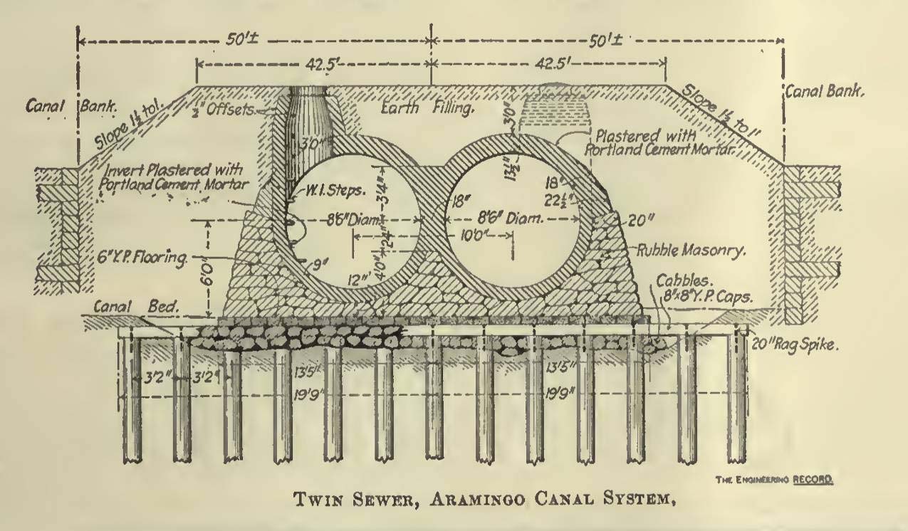
Construction of the sewer within the Gunner’s Run stream bed and the Aramingo Canal began at the northern reaches, from Somerset to Ann Street and beyond, and worked south toward the river. Several contractors were hired to build the sewer within the waterway, while others were hired to repair old connectors or construct new sewers that would feed into the canal 107. Three feet of earth were to cover the sewer, and manholes were specified every 300 feet. Construction required banking, or damming, portions of the sides and ends of the canal, then pumping to drain the water. The design north of Girard Avenue consisted of brick circular twin sewers, 8-feet 6-inches in diameter, resting on a concrete foundation. A change in surface grade was necessary along the margins of the canal, and some landowners sold dumping privileges as a means of bringing their land up to the new level 108.
Over a period of several years, construction moved slowly southward toward the Delaware River. As of 1895, the northern parts of the canal and Gunner’s Run had been successfully converted to sewer. From York Street north, the former canal and new sewer had also been covered over by a new public roadway named – appropriately enough – Aramingo Avenue, while the section between Norris and York Streets were sealed beneath a rail, coal, and lumber yard operated by the Pennsylvania Rail Road. At that time, the only remaining open water section of the canal extended from the Delaware River to Norris Street, where it terminated in a wooden “bulkhead” 109 (Figure 2.21).
.")
A lingering reminder of the Aramingo Canal in a hand-painted warning on the north side of the Norris Street bridge. The statement reads, “All persons are forbidden under penalty of law to make fast boats, scows, or rafts to any part of this bridge” (Source: Philadelphia Water Department 1900–1902).
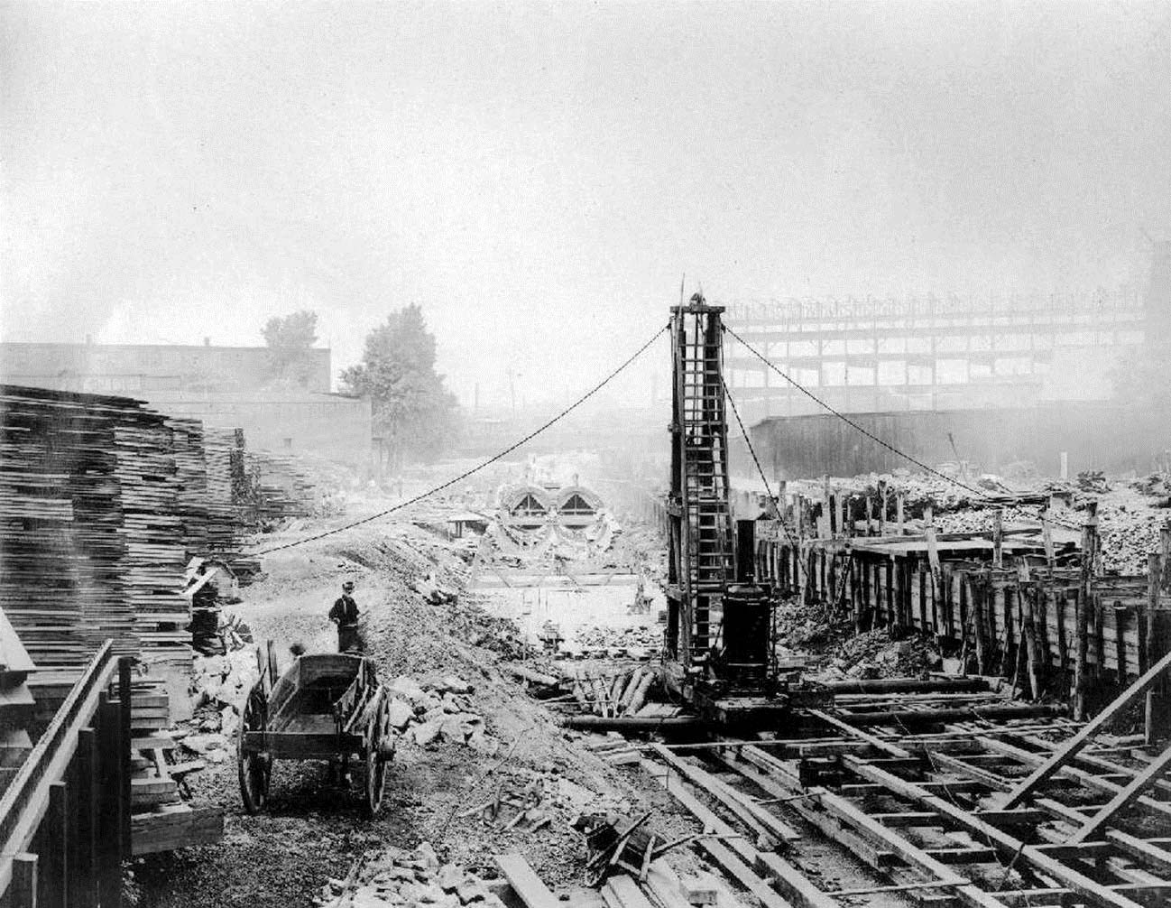
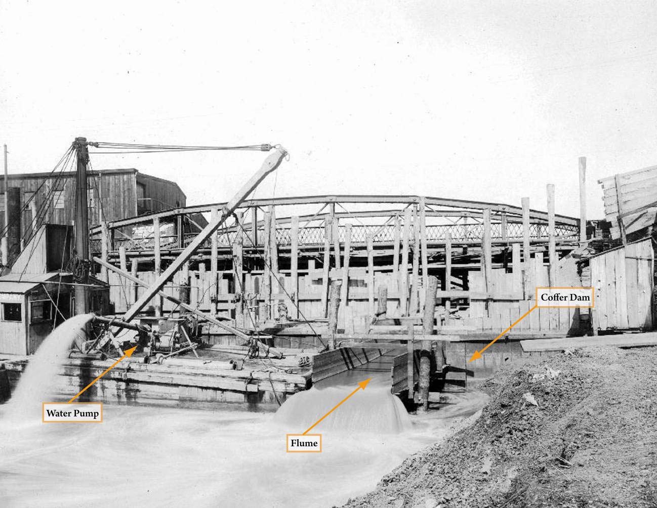
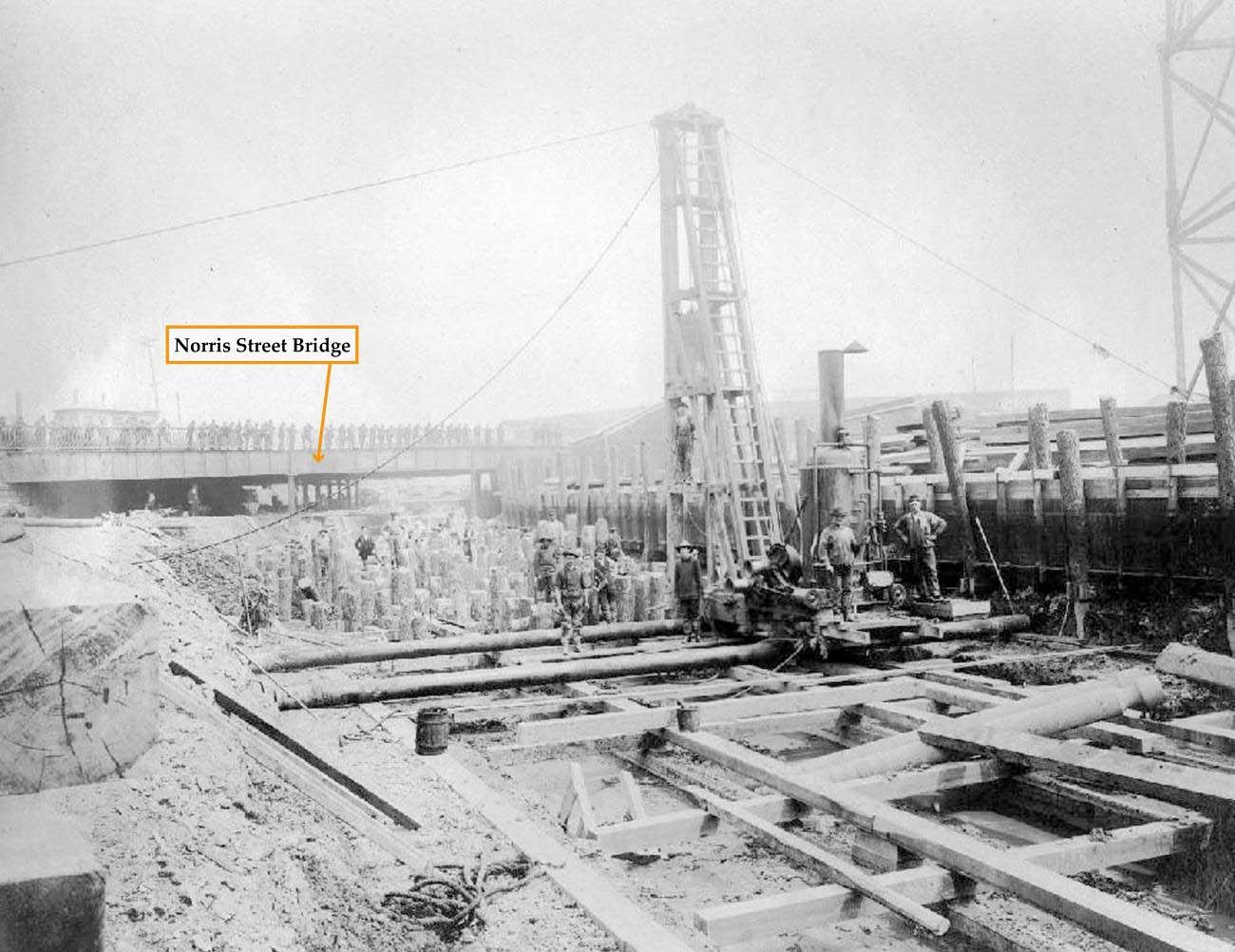
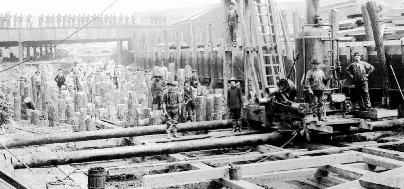
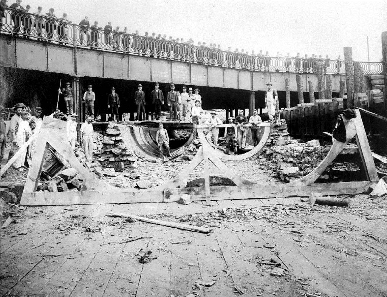
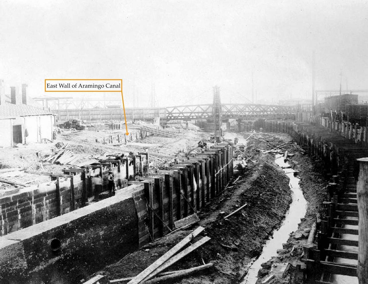
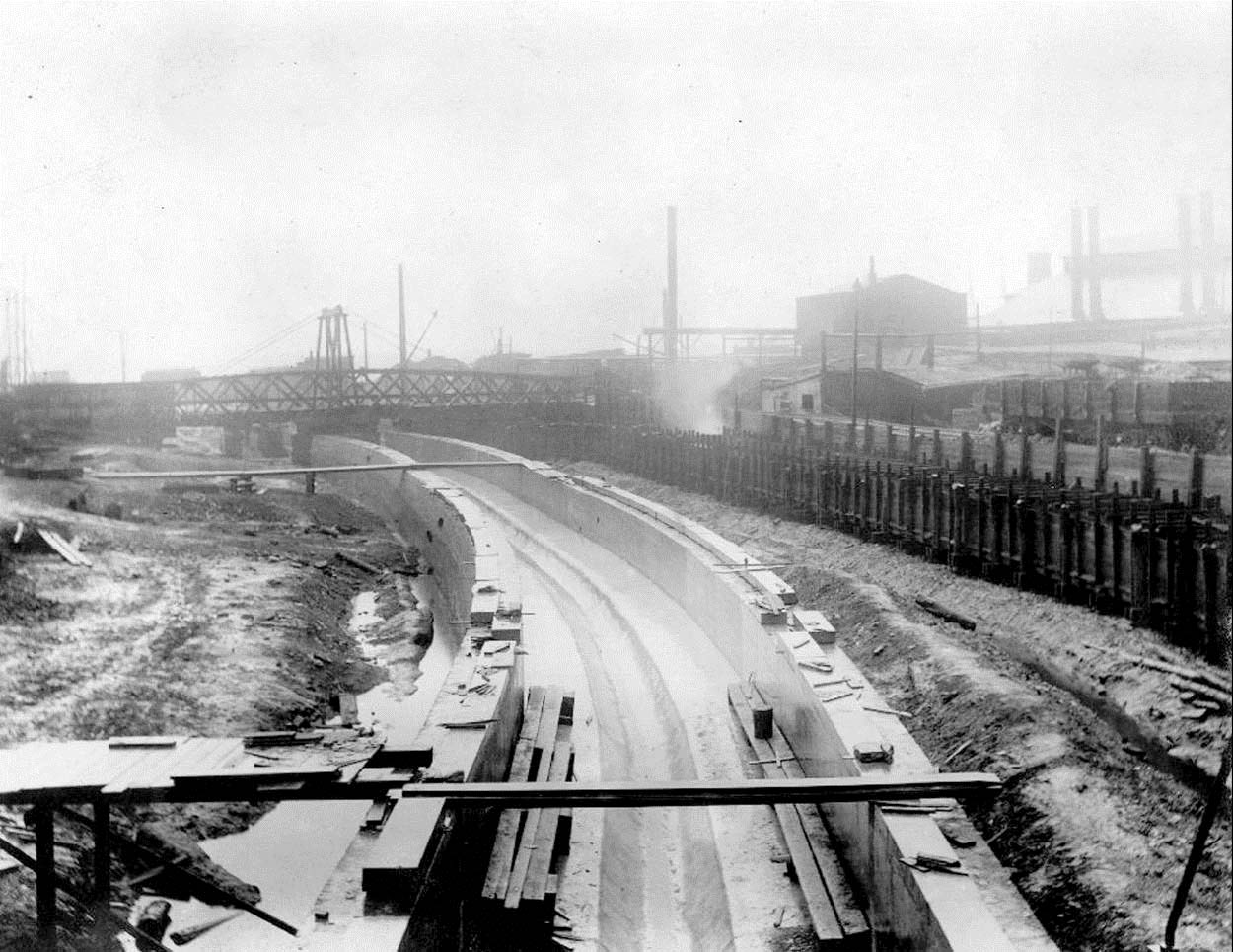
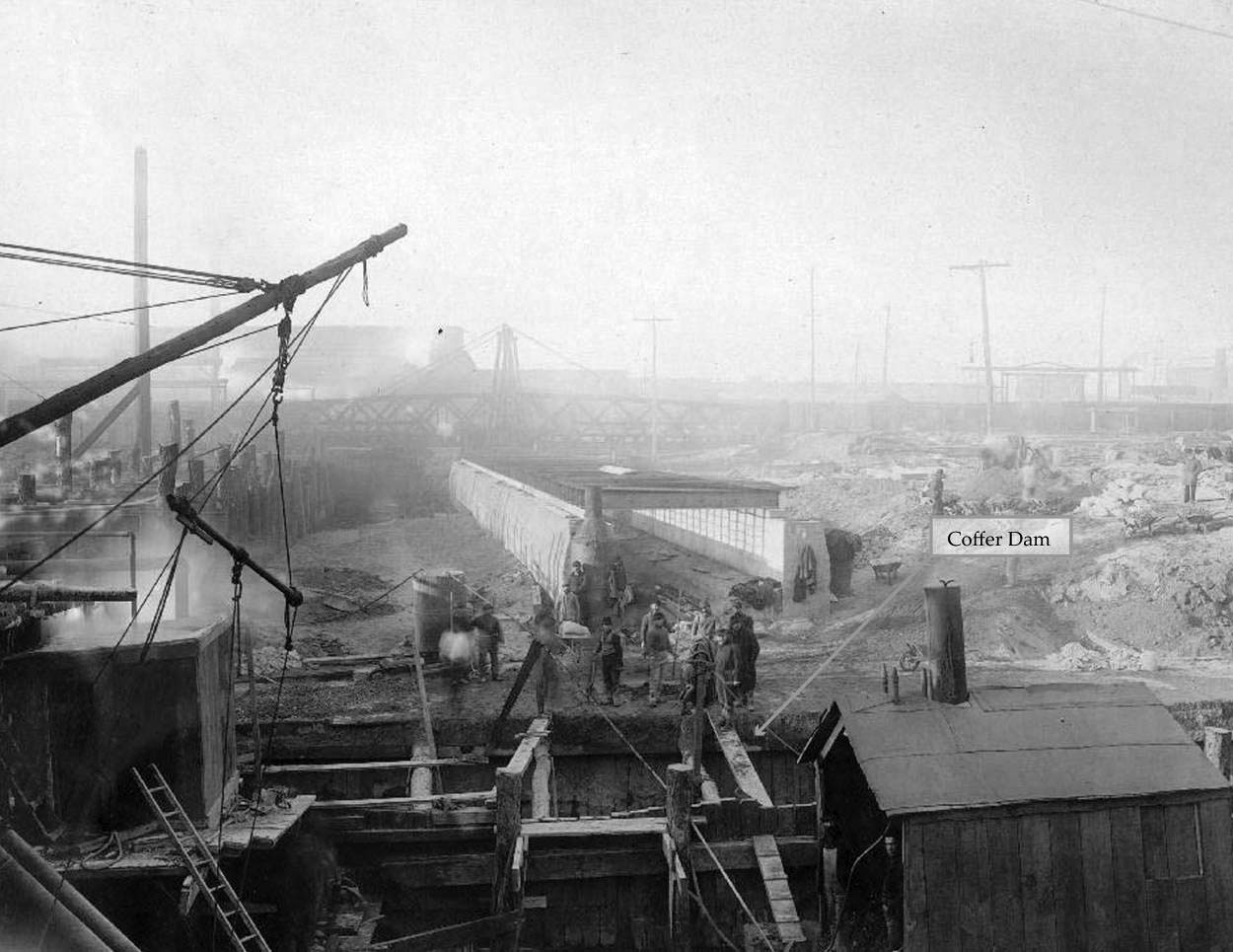
By 1898, conversion of the final 1,500 feet of the former canal, from the Girard Avenue/Norris Street intersection to the river, had been authorized. Funding was finally attained when the Pennsylvania Supreme Court enabled the city to negotiate $11,200,000 in bonds, of which $200,000 was targeted to complete the canal-to-sewer conversion 110. On August 25, 1899, Michael O’Rourke was awarded the contract for this project, and was ordered to proceed with the work on September 7 of that year 111. Construction activities progressed rapidly, so that within just a few short months the only visible evidence of the canal remaining at the northern end of this section was a hand painted warning, in faded letters, across the northern side of the Norris Street bridge (Figure 2.22). Recorded accounts of this construction, along with surviving historical photographs in the Philadelphia Water Department archives, serve to document the process involved in this monumental undertaking (Figures 2.23, 2.24, 2.25, 2.26, 2.27, 2.28, 2.29, 2.30, 2.31, 2.32).
The northernmost part of this section, between Norris and the north building line of Richmond Streets, was bordered with cribbed wharves and therefore could be converted in the same manner as canal sections further north. As a result, the same 8-foot 6-inch diameter twin sewer construction was possible. O’Rourke built this segment of the sewer “in the dry” by installing one or more timber coffer dams across the canal downstream, draining the canal water using hydraulic pumps, and removing the thick deposits of mud that had accumulated in the canal prism. Water and waste travelling through the already completed sewer section north of Norris Street was bridged across the active construction zone by way of a large elevated wooden flume built within the outer margins of the old canal bed (Figure 2.25). Because the natural soil, gravel, and rock underlying the canal provided an insufficiently rigid base upon which to build the sewer, the canal bottom first required firming-up through the driving of a dense array of yellow pine piles, the laying of a cobblestone base, and the construction of a level platform. On top of this base, the twin brick sewers were built in a rubble masonry cradle and then plastered inside and out with Portland Cement. Three feet of earth was then deposited to bury the new sewer 112.
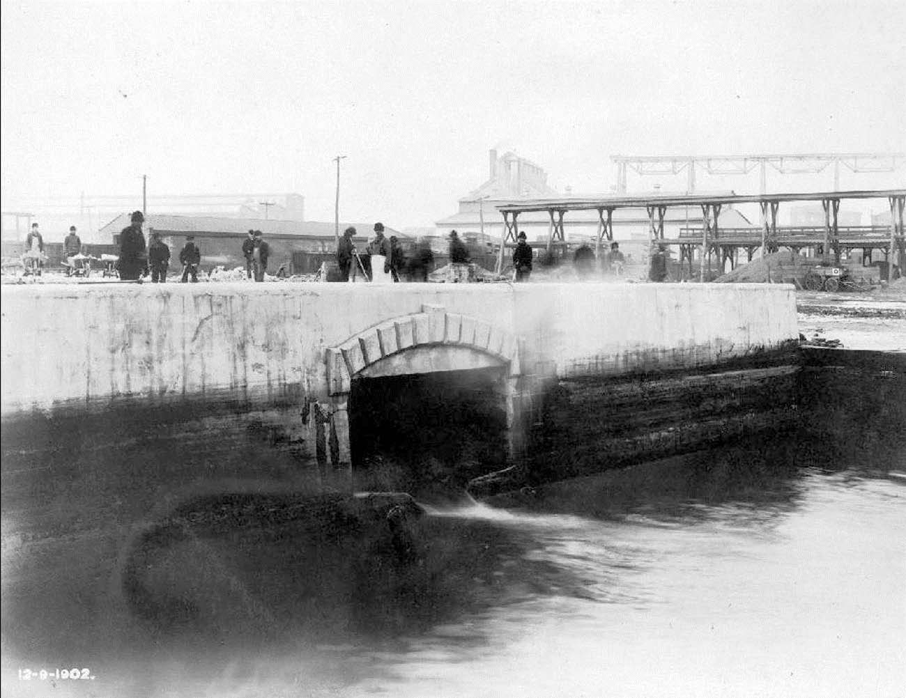
From Richmond Street to the Delaware River a different construction approach was necessary. At Richmond Street O’Rourke built a large “junction chamber”, of concrete with a granolithic finish, to connect the northern and southern sewer sections. South of Richmond Street the twin sewer formulation was abandoned in favor of a rectangular chamber measuring 6 feet high, by 14 feet wide 113. This portion of the sewer also utilized a base of timber piles and platform, and was constructed using concrete floor and sides, and a roof of steel beams filled in with brick arches. Though originally planned to be built partially underwater, with individual pre-formed concrete bottom sections lowered into place, O’Rourke eventually altered this scheme and went back to the coffer-dam assisted “in the dry” method used previously 114. At the mouth of the former canal, a large concrete bulkhead provided an outlet for the sewer to empty into the Delaware River.
When the task of converting the final section of the canal was completed in 1902—two years over schedule and thousands of dollars over budget—the new sewer system was hailed as a spectacular feat of engineering 115. From Norris Street to the Delaware River, the old canal bed was covered over with a new city street, named Dyott, and those in the city with a fondness for history were left to memorialize and mourn the passing of one of the last of the city’s original stream courses.
References
- Kraft (2001). The Lenape-Delaware Indian Heritage: 10,000 BC-AD 2000 ↩
- Remer (2002). Old Kensington; Milano (2010). Hidden history of Kensington & Fishtown ↩
- Cotter, Roberts and Parrington (1993). The buried past: An archaeological history of Philadelphia; Hoogenboom and Klein (1980). A History of Pennsylvania ↩
- Milano (2008). Shackamaxon Timeline. Encyclopaedia Kensingtoniana ↩
- Rambo (1948). The First Pioneers: The Rambo Family ↩
- Cotter, Roberts and Parrington (1993). The buried past: An archaeological history of Philadelphia ↩
- URS Corporation (URS) (2003). Historic Structures Survey/ Determination of Eligibility, Report S.R.0095, Sec. GIR, Interstate 95/Girard Avenue Interchange. Federal Project No. 1-0095-03-GIR-0650-316 MPMS No.17821 E.R. No. 01-8007-101 ↩
- Remer (2002). Old Kensington ↩
- Janney (1852). The Life of William Penn: With Selections from His Correspondence and Auto-biography ↩
- Historical Society of Pennsylvania (HSP) and Armstrong (1860). Records of Upland Court from the 14th of November, 1676 to the 14th of June 1681 ↩
- Remer (2002). Old Kensington ↩
- Remer (2002). Fishtown and the Shad Fisheries ↩
- Gans (1900). A Pennsylvania Pioneer: biographical sketch, with report of the executive committee of the Ball Estate Association ↩
- Milano (2008). Remembering Kensington & Fishtown : Philadelphia; Scharf and Westcott (1884). History of Philadelphia, 1609-1884 ↩
- Milano (2008). Remembering Kensington & Fishtown : Philadelphia ↩
- Scharf and Westcott (1884). History of Philadelphia, 1609-1884 ↩
- Remer (2002). Old Kensington ↩
- Remer (2002). Old Kensington ↩
- Westcott (1895). The Historic Mansions and Buildings of Philadelphia: With Some Notice of Their Owners and Occupants ↩
- Scharf and Westcott (1884). History of Philadelphia, 1609-1884 ↩
- Scharf and Westcott (1884). History of Philadelphia, 1609-1884 ↩
- Kooch (1834). Extracts from the Manuscript of Kooch ↩
- McKearin (1970). Bottles, Flasks and Dr. Dyott ↩
- Barnard (1907). Factory Legislation in Pennsylvania: Its History and Administration ↩
- McKearin (1970). Bottles, Flasks and Dr. Dyott ↩
- McKearin (1970). Bottles, Flasks and Dr. Dyott ↩
- Wadhwani (2007). The Demise of Thomas Dyott: Experimenting with Popular Finance in Jacksonian Philadelphia ↩
- McKearin (1970). Bottles, Flasks and Dr. Dyott ↩
- Dawson (2004). Lives of the Philadelphia engineers: capital, class, and revolution, 1830-1890 ↩
- Cramp, William and & Sons Ship & Engine Building Company (1902). Cramp’s Shipyard ↩
- Macfarlane (1912). Manufacturing in Philadelphia: 1683-1912: With photographs of some of the leading industrial establishments ↩
- Global Security (2010). William Cramp & Sons Shipbuilding Company ↩
- Anonymous (1891). Philadelphia and Popular Philadelphians ↩
- Dixon (1990). Fishtown, an Overview ↩
- Dixon, Elk and Weber (1989). The Fishtown Architectural and Archaeological Industrial Survey ↩
- Freedley (1857). Philadelphia and Its Manufactures: A Handbook Exhibiting the Development ↩
- Dixon (1990). Fishtown, an Overview ↩
- Milano (2008). Remembering Kensington & Fishtown : Philadelphia ↩
- Remer (2002). Old Kensington ↩
- Scharf and Westcott (1884). History of Philadelphia, 1609-1884 ↩
- Milano (2008). Remembering Kensington & Fishtown : Philadelphia ↩
- Taylor (1848). Statistics of Coal: The Geographical and Geological Distribution of Mineral Combustibles or Fossil Fuel ↩
- Taylor (1848). Statistics of Coal: The Geographical and Geological Distribution of Mineral Combustibles or Fossil Fuel ↩
- Childs (1874). Public Ledger Almanac ↩
- Weigley, Wainwright and Wolf (1982). Philadelphia: A 300 Year History ↩
- Independence Hall Association (2010). A Brief History of Philadelphia: Port Richmond ↩
- Remer (2002). Old Kensington ↩
- Dixon, Elk and Weber (1989). The Fishtown Architectural and Archaeological Industrial Survey ↩
- Freedley (1857). Philadelphia and Its Manufactures: A Handbook Exhibiting the Development ↩
- Watson (1879). Annals of Philadelphia and Pennsylvania in Three Volumes ↩
- City of Philadelphia Law Department (1847). Laws Enacted in the General Assembly of the Commonwealth ↩
- McElroy (1847). McElroy’s Philadelphia Directory for 1847; United States Bureau of the Census (1850). Philadelphia, Philadelphia County, Pennsylvania, Population Schedule ↩
- (1848). Gunner’s Run ↩
- (n.d.). A digest of the acts of Assembly relating to the city of Philadelphia and the (late) incorporated districts of the county of Philadelphia, and of the ordinances of the said city and districts, in force on the first day of January, A.D. 1856 ↩
- (n.d.). A digest of the acts of Assembly relating to the city of Philadelphia and the (late) incorporated districts of the county of Philadelphia, and of the ordinances of the said city and districts, in force on the first day of January, A.D. 1856 ↩
- (n.d.). A digest of the acts of Assembly relating to the city of Philadelphia and the (late) incorporated districts of the county of Philadelphia, and of the ordinances of the said city and districts, in force on the first day of January, A.D. 1856 ↩
- (1850). The Gunner’s Run Improvement ↩
- (n.d.). A digest of the acts of Assembly relating to the city of Philadelphia and the (late) incorporated districts of the county of Philadelphia, and of the ordinances of the said city and districts, in force on the first day of January, A.D. 1856; Cotter, Roberts and Parrington (1993). The buried past: An archaeological history of Philadelphia ↩
- (1897). Passing of Gunner’s Run ↩
- Scharf and Westcott (1884). History of Philadelphia, 1609-1884 ↩
- City of Philadelphia Law Department (1856). Laws Enacted in the General Assembly of the Commonwealth ↩
- Pennsylvania General Assembly (1854). The Consolidation bill: as finally passed by the Pennsylvania legislature, January 31, 1854 ↩
- Watson (1879). Annals of Philadelphia and Pennsylvania in Three Volumes ↩
- Speirs (1897). The Street Railway System of Philadelphia: Its History and Present Condition” ↩
- Dixon, Elk and Weber (1989). The Fishtown Architectural and Archaeological Industrial Survey ↩
- Meyers and Spivak (2003). Philadelphia Trolleys ↩
- Heffrich (1893). Philadelphia securities: A Descriptive and Statistical Manual of the Corporations of the City of Philadelphia ↩
- Lower Merion Historical Society (2010). William McDowell’s Olinda ↩
- Hexamer, Ernest and and Son (Hexamer) (1887). Leibrandt and McDowell Stove Company ↩
- Anonymous (1891). Philadelphia and Popular Philadelphians ↩
- (1918). American Biography: A New Cyclopedia ↩
- Gillingham (1901). Gillingham Family: Descendants of Yeamans Gillingham ↩
- Hexamer, Ernest and and Son (Hexamer) (1879). Brown and Woelpper’s Sawing and Planing Mill and Lumber Yard ↩
- Congdon (1893). History of the Master Builders exchange of the city philadelphia from its organization in year 1886 to 1893 ↩
- Hexamer, Ernest and and Son (Hexamer) (1875). Philadelphia Lead Works ↩
- Hexamer, Ernest and and Son (Hexamer) (1875). Philadelphia Lead Works ↩
- (1876). New Bridge over Gunner’s Run ↩
- Watson (1879). Annals of Philadelphia and Pennsylvania in Three Volumes ↩
- Scharf and Westcott (1884). History of Philadelphia, 1609-1884 ↩
- West Publishing Company (1895). Atlantic Reporter; (1897). Passing of Gunner’s Run ↩
- (1869). Drowned in Gunner’s Run ↩
- Warner (1987). The Private City: Philadelphia in Three Stages of Its Growth ↩
- (1861). Article addressing water quality of Aramingo Canal ↩
- Van Baum (1883). Kensington Water Supply ↩
- (1872). Report on Water Quality and Sanitation Conditions in Philadelphia ↩
- (1875). Local News ↩
- (1880). Drowned in Gunner’s Run ↩
- (1893). A Child’s Body Found in Gunner’s Run ↩
- McCarthy (1987). Typhoid and the politics of public health in nineteenth-century Philadelphia ↩
- (1889). Protesting Against Gunner’s Run ↩
- Cutter (1901). The Aramingo Drainage System ↩
- Warner (1987). The Private City: Philadelphia in Three Stages of Its Growth ↩
- Van Baum (1883). Kensington Water Supply ↩
- West Publishing Company (1895). Atlantic Reporter ↩
- (1889). Breeding Diseases Typhoid Fever Holds High Carnival Along Gunner’s Run ↩
- West Publishing Company (1895). Atlantic Reporter ↩
- (1897). Passing of Gunner’s Run ↩
- The Extinction of Gunner’s run and aramingo canal stupendous feat of engineering now taking place ↩
- Cutter (1901). The Aramingo Drainage System ↩
- (1889). Breeding Diseases Typhoid Fever Holds High Carnival Along Gunner’s Run; (1889). Gunner’s Run Must Go a Physician Says the District Has Not Been Free from Fever ↩
- West Publishing Company (1895). Atlantic Reporter ↩
- City of Philadelphia Law Department (1894). Ordinances of the City of Philadelphia, from January 1 to December 31, 1893. And Opinions of the City Solicitor ↩
- (1889). Gunner’s Run Must Go a Physician Says the District Has Not Been Free from Fever ↩
- (1893). Disputes Arising Over Abandonment of the Aramingo Canal as a Waterway ↩
- City of Philadelphia (1889). Third Annual Message of Edwin Fitler, Mayor, City of Philadelphia, with Annual Reports of Louis Wagner, Director of Department of Public Works, and of the Chiefs of Bureaus Constituting Said Department for the Year Ending December 31, 1889 ↩
- (1893). Disputes Arising Over Abandonment of the Aramingo Canal as a Waterway ↩
- City of Philadelphia Law Department (1894). Ordinances of the City of Philadelphia, from January 1 to December 31, 1893. And Opinions of the City Solicitor ↩
- Cutter (1901). The Aramingo Drainage System ↩
- (1897). Passing of Gunner’s Run ↩
- (1899). Loan Bill Funds Now Available Supreme Court Affirms the Validity of Much Fought-over Measure Cash ↩
- City of Philadelphia (1903). Fourth Annual Message of Samuel H. Ashbridge, Mayor of the City of Philadelphia, with Annual Reports by William C. Haddock, Director of the Department of Public Works, and of the Bureau of Surveys, Year Ending December 31, 1902 ↩
- Cutter (1901). The Aramingo Drainage System; City of Philadelphia (1903). Fourth Annual Message of Samuel H. Ashbridge, Mayor of the City of Philadelphia, with Annual Reports by William C. Haddock, Director of the Department of Public Works, and of the Bureau of Surveys, Year Ending December 31, 1902 ↩
- City of Philadelphia (1903). Fourth Annual Message of Samuel H. Ashbridge, Mayor of the City of Philadelphia, with Annual Reports by William C. Haddock, Director of the Department of Public Works, and of the Bureau of Surveys, Year Ending December 31, 1902 ↩
- City of Philadelphia (1902). Third Annual Message of Samuel H. Ashbridge, Mayor of the City of Philadelphia, with Annual Reports by William C. Haddock, Director of the Department of Public Works, and of the Bureau of Surveys, Year Ending December 31, 1901; Pennsylvania Courts (1912). The District Reports of Cases Decided in All the Judicial Districts of the State of Pennsylvania ↩
- City of Philadelphia (1902). Third Annual Message of Samuel H. Ashbridge, Mayor of the City of Philadelphia, with Annual Reports by William C. Haddock, Director of the Department of Public Works, and of the Bureau of Surveys, Year Ending December 31, 1901 ↩