ARCHAEOLOGY AT THE
CRAMP/BUMM SITE
1018 PALMER ST
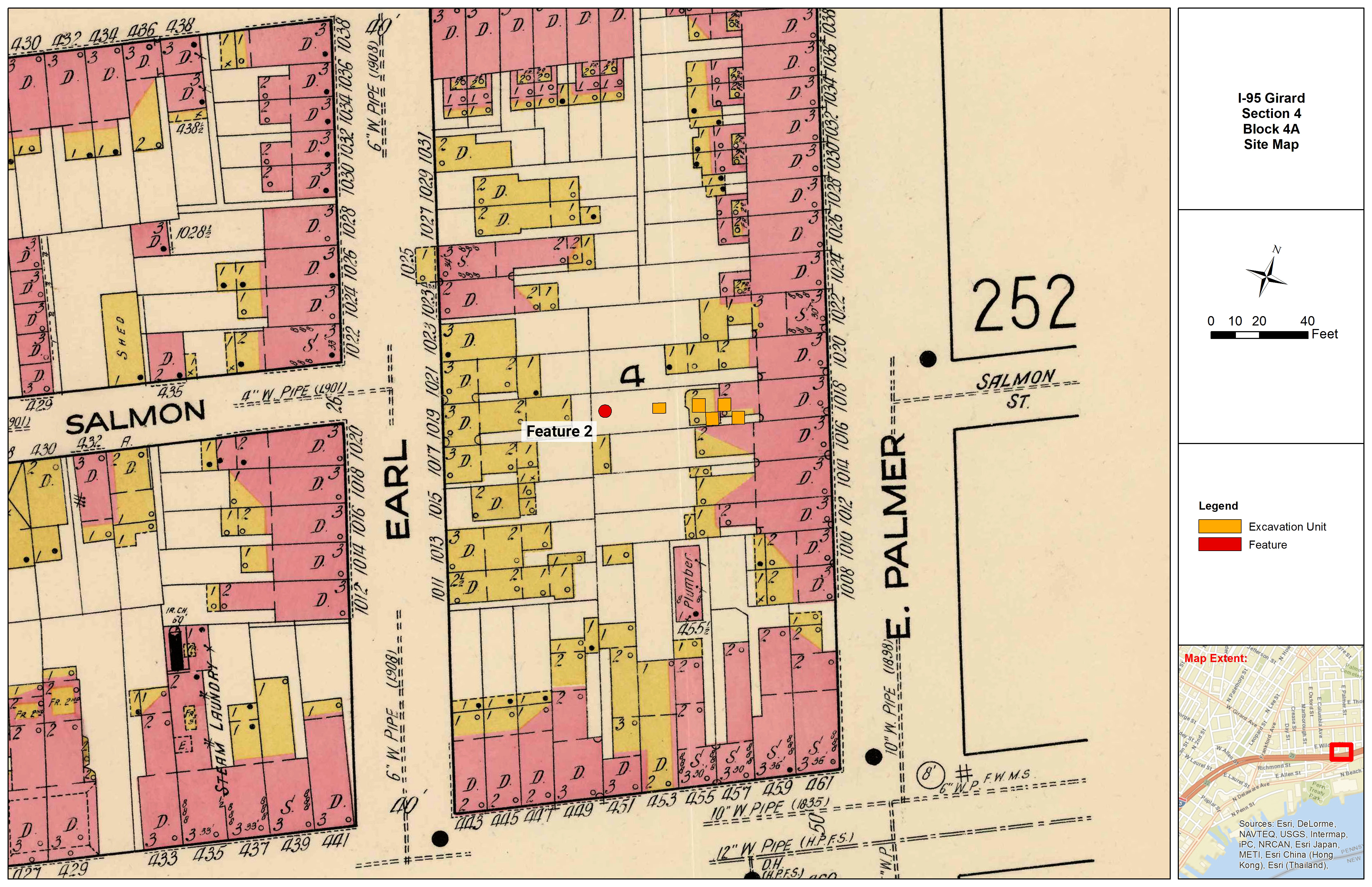
The Cramp/Bumm Site was located at the former 1018 Palmer Street property, now part of the PennDOT right-of-way along the southbound side of the roadway. At the time of the initial excavation, the site was situated on a 10-foot-wide, flat, grassy tract of land that abruptly transitioned into a steeply sloped embankment to the east, adjacent to southbound I-95. The site was bounded by 1020 Palmer Street to the west, I-95 to the east, and Ross/Earl Street to the south. The roadway embankment limited the initial excavation to the area located along the west edge of the property. Later, during archaeological monitoring, the area expanded to the full backyard of 1018 Palmer Street.
Explore
CRAMP-BUMM:
DISCOVER
Artifacts in Everyday Life
Archaeological excavation of 1018 Palmer Street revealed several notable features, consisting of one brick-lined shaft, one domestic refuse pit, two post features, and one French drain–like feature—all identified along the western portion of the property adjacent to 1020 Palmer Street. The overwhelming majority of artifacts (96.6%) associated with feature deposits were recovered from the brick shaft designated Feature 2. In addition to their contributions to geomorphology and historic landscape modifications, excavation units in the backyard also yielded an assemblage of 1,415 artifacts. However, the majority of the total artifact assemblage (7,430) was recovered from feature-related deposits.
Excavation Units
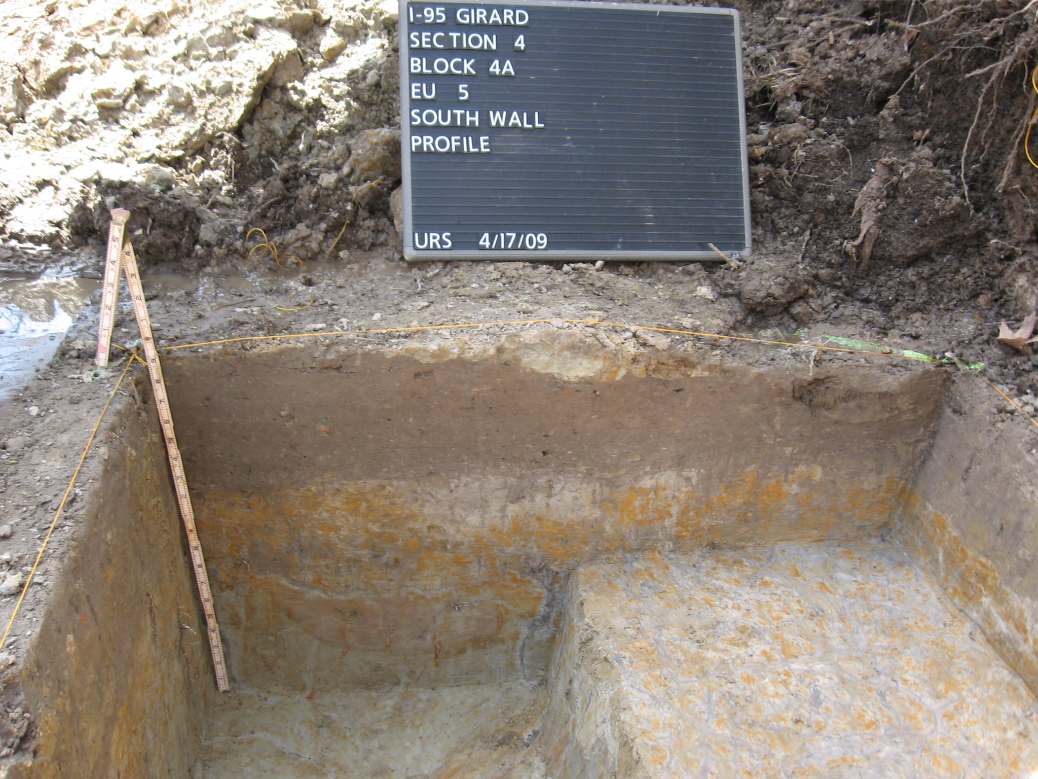
Archaeological excavation at 1018 Palmer Street involved the placement of five excavation units (each measuring 5 x 5 feet), revealing mixed deposits identified within the footprint of the rear additions to the main house, and an A-horizon yard deposit in the open backyard area behind the house. Excavation Units 1 through 4 were located within the building footprint of 1018 Palmer Street, probably in the frame addition area attached to the rear of the main house, as shown on the 1916 Sanborn map; Unit 5 is located in approximately the center of the rear yard. Units 1 through 4 revealed sandy loam fill deposits, approximately 1 foot thick (Strats I and II) and containing a high density of mixed historic artifacts overlying subsoil. Excavation Unit 5 revealed a silty loam yard deposit (Strat I), approximately 0.7 feet thick, containing a variety of historic artifacts dating from the early through late nineteenth century. Silt and clay subsoil (Strat II and III) was encountered directly beneath the yard deposit.
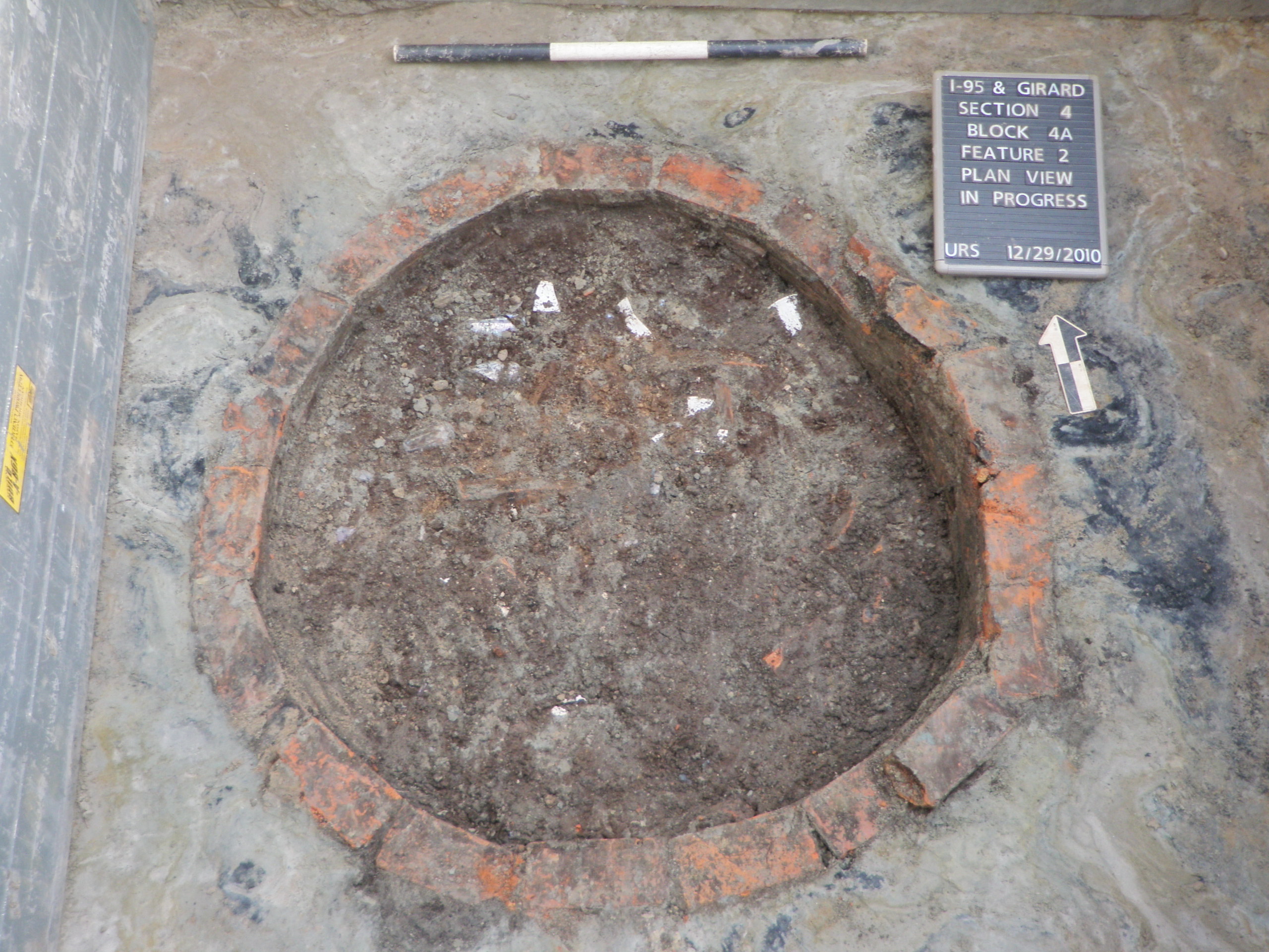
Brick Shaft Feature
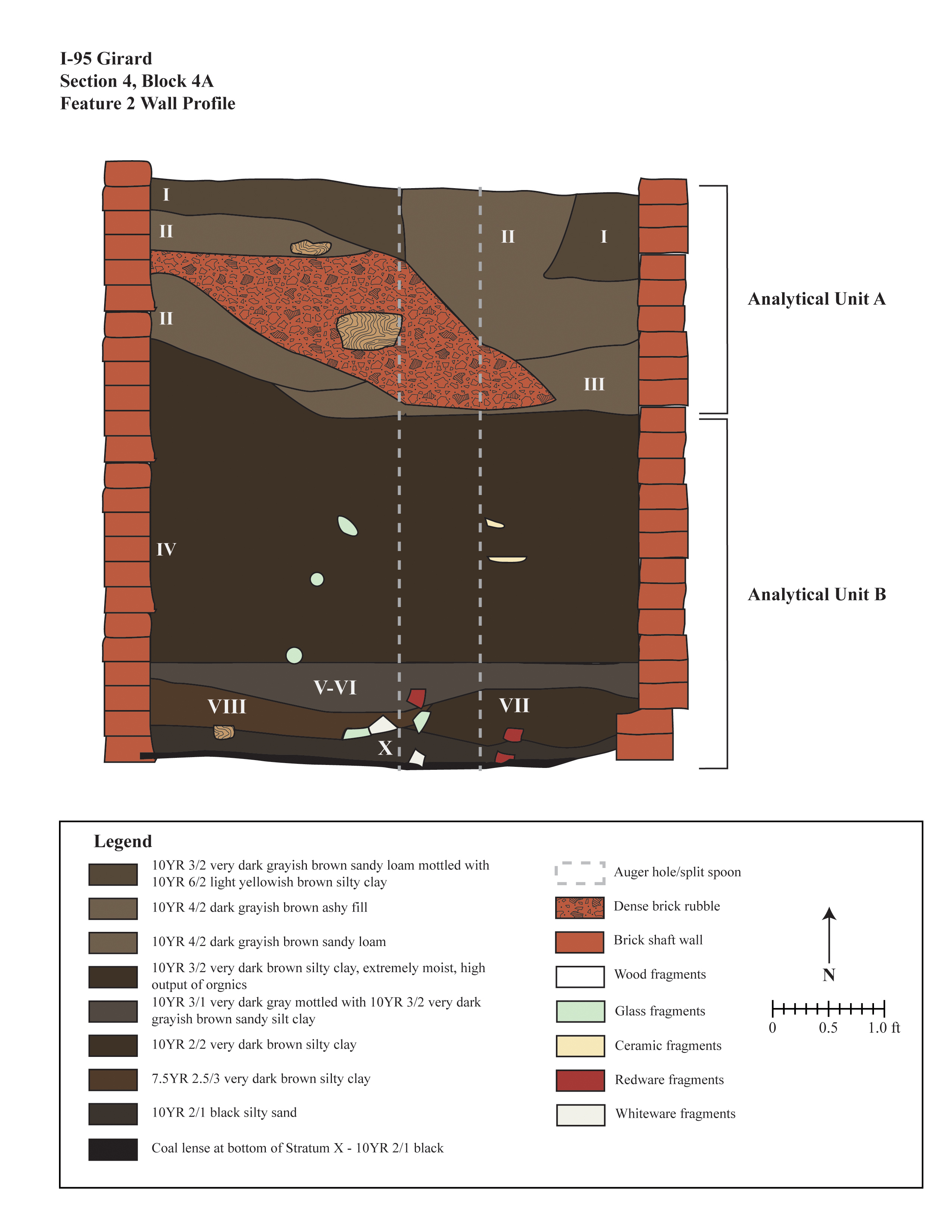
Located at the rear of the 1018 Palmer Street lot, Feature 2 was a circular, brick-lined privy shaft—approximately 5 feet in diameter—exposed during machine removal of overlying fill deposits. The shaft feature extended to a depth of 5.78 feet below the historic ground surface and was initially tested by drilling a core sample/split spoon to determine the artifact content of the fill prior to hand excavation. Based on the results of the core sample, it was determined that the shaft fill contained a sufficient number of artifacts to warrant further excavation. Two analytical units (distinct soil deposits) were identified within the shaft fill. Of the 10 stratigraphic fill layers identified, five lower strata (Strats IV, VII, VIII, IX, and X) are considered one analytical unit (B) based on numerous artifact crossmends. These deposits appear related to repurposing an abandoned privy as a trash pit. The second analytical unit (A) consists of the uppermost deposits (Strats I–III), comprised of sandy loam and ash fill deposits unrelated to the lower fill strata. These fill strata correlate with the early-twentieth-century occupation of the property.
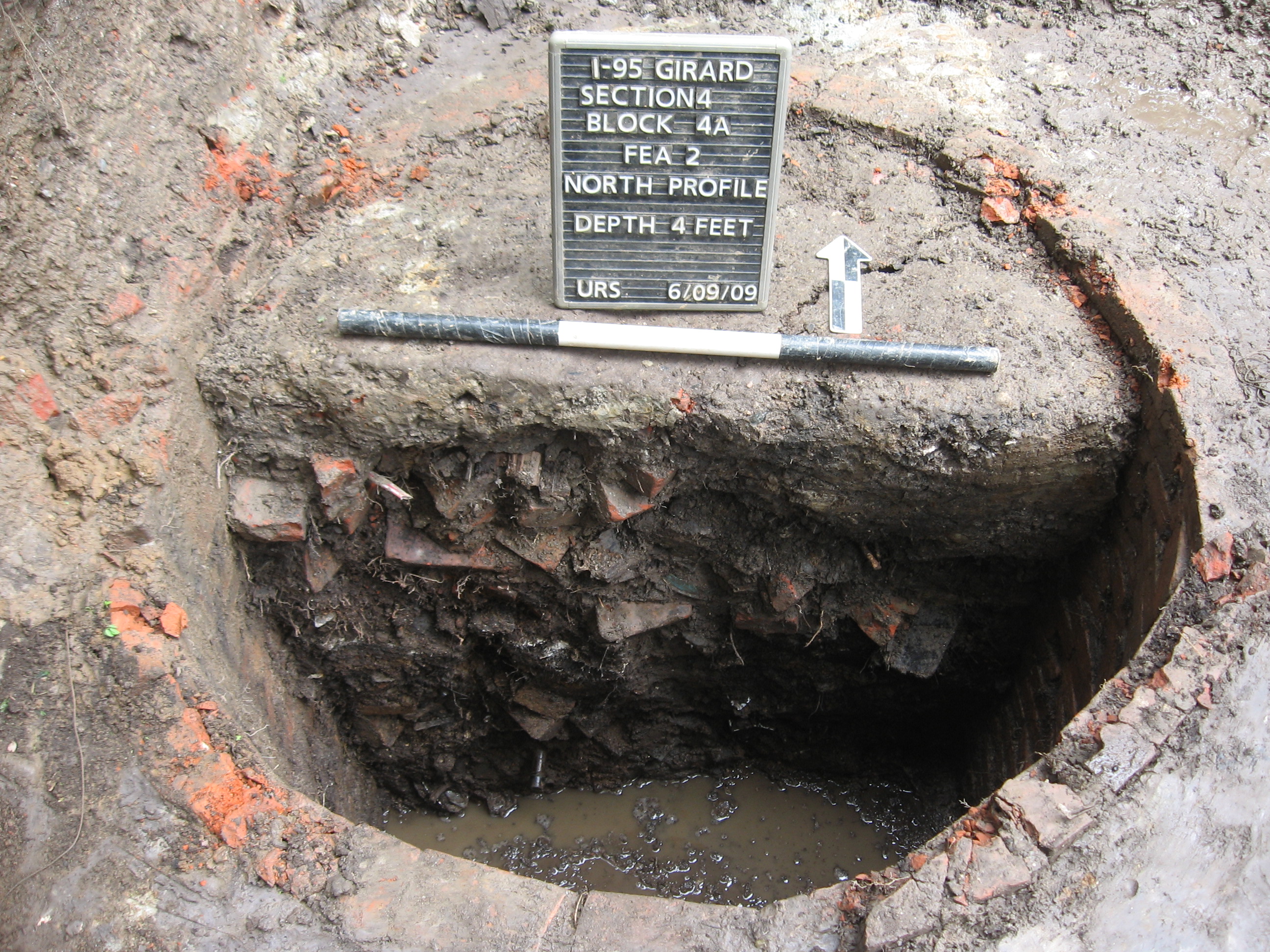
The excavation of Feature 2 yielded a total of 6,015 artifacts. Strats IV, V, VI, and VII contained the majority of artifacts recovered from Feature 2, with crossmends throughout these fill deposits. Artifacts from these strata largely date to the occupation of the property by the Cramp family (1850 – 1889) and Bumm families (1889 – 1914). Fewer artifacts can be attributed to the Nickel family, who occupied the property between 1914 and 1920. Strats I–III are fill deposits related to the later Nickel family period of occupation and the final closing of the shaft. A total of three artifact crossmends were observed between Strat III (Analytical Unit A) and Strat IV (Analytical Unit B), a probable result of minimal mixing between the two deposits, as Strat III directly overlaid Strat IV. There were no other crossmends between the two analytical units. Ceramic dating analysis does not indicate a significant difference in date ranges between the two analytical units; however, dating analysis of glass, notably bottles, revealed two distinct dates of deposition, with Analytical Unit A having a later date range grouping between 1870 and 1920. In contrast, Analytical Unit B evidence reveals a strong date range grouping of bottle glass between 1840 and 1890 5- digitized profile.
Other Features
One semi-circular pit feature (Feature 1) was documented in the 1018 Palmer Street lot, exposing a portion measuring 2.8 x 1.25 feet. Recovered during unit excavation, the true boundaries of this feature—which consisted of mixed sandy loam soil—extended beyond the limits of the unit excavation and could not be defined. The top section of Feature 1 was removed via construction-related activities, as only 0.25 feet of the feature remained below the historic ground surface, containing only 18 artifacts.
A total of two square post features (Feature 5 and 6) were recorded and investigated. Feature 5, located in Excavation Unit 1, consisted of a 0.87-foot square and extended to a depth of approximately 1 foot below the Ap horizon. Feature 6 was a 0.7-foot square, documented approximately 0.8 feet below the historic ground surface. A total of five artifacts were recovered from the two features.
Feature 4, exposed in Unit 1, was a possible drainage feature. Extending beyond the boundaries of unit excavation, the exposed feature measured 5 x 2.6 feet and consisted of a concentration of stone rubble that may relate to the drainage feature. Feature 4 yielded a relatively high distribution of domestic cultural materials, totaling 238 artifacts, such as creamware, pearlware, whiteware, ironstone, and porcelain ceramic sherds, along with container glass and beer/soda bottles.
summary
As identified through archaeological excavations, residential backyard soil deposits provide some of the best examples for the preservation of the original topography in highly modified urban landscapes. The poorly drained soils revealed in the backyard of 1018 Palmer Street indicate a wetland environment or possibly a local stream (which may have had its outlet at the Delaware River) originally existed northwest of Palmer Street. As a result, persistent wet conditions characterized the soils at the Cramp-Bumm Site. Historically in urban settings, these types of wetland environments were stabilized through the deposition of fill, as exhibited in the site stratigraphy. The high water table, which proved to be problematic during excavation of the privy shaft feature (Feature 2), provides evidence that landscape modifications such as fill deposition were necessary prior to residential construction in this area. The condition of feature deposits and the historic ground surface (Ap horizon) prior to excavation indicated that they were significantly reduced during the demolition of the house and other activities stemming from the initial construction of I-95.
ARCHAEOLOGY AT THE
CRAMP/BUMM SITE
1018 PALMER ST
The Cramp/Bumm Site was located at the former 1018 Palmer Street property, now part of the PennDOT right-of-way along the southbound side of the roadway. At the time of the initial excavation, the site was situated on a 10-foot-wide, flat, grassy tract of land that abruptly transitioned into a steeply sloped embankment to the east, adjacent to southbound I-95. The site was bounded by 1020 Palmer Street to the west, I-95 to the east, and Ross/Earl Street to the south. The roadway embankment limited the initial excavation to the area located along the west edge of the property. Later, during archaeological monitoring, the area expanded to the full backyard of 1018 Palmer Street.
Archaeological excavation of 1018 Palmer Street revealed several notable features, consisting of one brick-lined shaft, one domestic refuse pit, two post features, and one French drain–like feature—all identified along the western portion of the property adjacent to 1020 Palmer Street. The overwhelming majority of artifacts (96.6%) associated with feature deposits were recovered from the brick shaft designated Feature 2. In addition to their contributions to geomorphology and historic landscape modifications, excavation units in the backyard also yielded an assemblage of 1,415 artifacts. However, the majority of the total artifact assemblage (7,430) was recovered from feature-related deposits.
Excavation Units
Archaeological excavation at 1018 Palmer Street involved the placement of five excavation units (each measuring 5 x 5 feet), revealing mixed deposits identified within the footprint of the rear additions to the main house, and an A-horizon yard deposit in the open backyard area behind the house. Excavation Units 1 through 4 were located within the building footprint of 1018 Palmer Street, probably in the frame addition area attached to the rear of the main house, as shown on the 1916 Sanborn map; Unit 5 is located in approximately the center of the rear yard. Units 1 through 4 revealed sandy loam fill deposits, approximately 1 foot thick (Strats I and II) and containing a high density of mixed historic artifacts overlying subsoil. Excavation Unit 5 revealed a silty loam yard deposit (Strat I), approximately 0.7 feet thick, containing a variety of historic artifacts dating from the early through late nineteenth century. Silt and clay subsoil (Strat II and III) was encountered directly beneath the yard deposit.
Brick Shaft Feature
Located at the rear of the 1018 Palmer Street lot, Feature 2 was a circular, brick-lined privy shaft—approximately 5 feet in diameter—exposed during machine removal of overlying fill deposits. The shaft feature extended to a depth of 5.78 feet below the historic ground surface and was initially tested by drilling a core sample/split spoon to determine the artifact content of the fill prior to hand excavation. Based on the results of the core sample, it was determined that the shaft fill contained a sufficient number of artifacts to warrant further excavation. Two analytical units (distinct soil deposits) were identified within the shaft fill. Of the 10 stratigraphic fill layers identified, five lower strata (Strats IV, VII, VIII, IX, and X) are considered one analytical unit (B) based on numerous artifact crossmends. These deposits appear related to repurposing an abandoned privy as a trash pit. The second analytical unit (A) consists of the uppermost deposits (Strats I–III), comprised of sandy loam and ash fill deposits unrelated to the lower fill strata. These fill strata correlate with the early-twentieth-century occupation of the property.
The excavation of Feature 2 yielded a total of 6,015 artifacts. Strats IV, V, VI, and VII contained the majority of artifacts recovered from Feature 2, with crossmends throughout these fill deposits. Artifacts from these strata largely date to the occupation of the property by the Cramp family (1850 – 1889) and Bumm families (1889 – 1914). Fewer artifacts can be attributed to the Nickel family, who occupied the property between 1914 and 1920. Strats I–III are fill deposits related to the later Nickel family period of occupation and the final closing of the shaft. A total of three artifact crossmends were observed between Strat III (Analytical Unit A) and Strat IV (Analytical Unit B), a probable result of minimal mixing between the two deposits, as Strat III directly overlaid Strat IV. There were no other crossmends between the two analytical units. Ceramic dating analysis does not indicate a significant difference in date ranges between the two analytical units; however, dating analysis of glass, notably bottles, revealed two distinct dates of deposition, with Analytical Unit A having a later date range grouping between 1870 and 1920. In contrast, Analytical Unit B evidence reveals a strong date range grouping of bottle glass between 1840 and 1890 5- digitized profile.
Other Features
One semi-circular pit feature (Feature 1) was documented in the 1018 Palmer Street lot, exposing a portion measuring 2.8 x 1.25 feet. Recovered during unit excavation, the true boundaries of this feature—which consisted of mixed sandy loam soil—extended beyond the limits of the unit excavation and could not be defined. The top section of Feature 1 was removed via construction-related activities, as only 0.25 feet of the feature remained below the historic ground surface, containing only 18 artifacts.
A total of two square post features (Feature 5 and 6) were recorded and investigated. Feature 5, located in Excavation Unit 1, consisted of a 0.87-foot square and extended to a depth of approximately 1 foot below the Ap horizon. Feature 6 was a 0.7-foot square, documented approximately 0.8 feet below the historic ground surface. A total of five artifacts were recovered from the two features.
Feature 4, exposed in Unit 1, was a possible drainage feature. Extending beyond the boundaries of unit excavation, the exposed feature measured 5 x 2.6 feet and consisted of a concentration of stone rubble that may relate to the drainage feature. Feature 4 yielded a relatively high distribution of domestic cultural materials, totaling 238 artifacts, such as creamware, pearlware, whiteware, ironstone, and porcelain ceramic sherds, along with container glass and beer/soda bottles.
summary
As identified through archaeological excavations, residential backyard soil deposits provide some of the best examples for the preservation of the original topography in highly modified urban landscapes. The poorly drained soils revealed in the backyard of 1018 Palmer Street indicate a wetland environment or possibly a local stream (which may have had its outlet at the Delaware River) originally existed northwest of Palmer Street. As a result, persistent wet conditions characterized the soils at the Cramp-Bumm Site. Historically in urban settings, these types of wetland environments were stabilized through the deposition of fill, as exhibited in the site stratigraphy. The high water table, which proved to be problematic during excavation of the privy shaft feature (Feature 2), provides evidence that landscape modifications such as fill deposition were necessary prior to residential construction in this area. The condition of feature deposits and the historic ground surface (Ap horizon) prior to excavation indicated that they were significantly reduced during the demolition of the house and other activities stemming from the initial construction of I-95.