Introduction
The following management summary documents the preliminary findings of Phase IB/II archaeological excavations performed as part of the I-95/GIR Improvement Corridor Project for the Pennsylvania Department of Transportation (PennDOT), Engineering District 6-0. URS Corporation (URS) performed these investigations within a portion of the GR-1 section of the larger project area, and specifically within a study area that extended along the eastern shoulder of Richmond Street, from Dyott Street to Schirra Lane. The work was conducted in accordance with Section 106 of the National Historic Preservation Act of 1966, as amended; 36 CFR Part 800, particularly sections 800.4, and 800.5; the Section 106 Programmatic Agreement of 2010; as well as the Pennsylvania Historical and Museum Commission (PHMC), Bureau of Historic Preservation (BHP) Guidelines for Archaeological Investigations (2008).
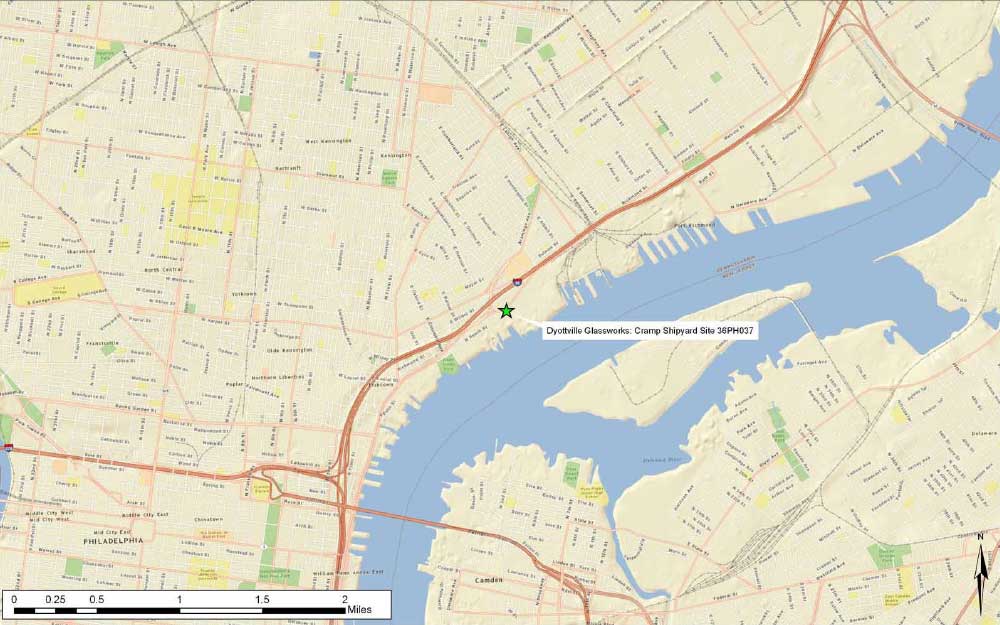
Testing targeted a portion of the former Dyottville Glass Works1 complex contained beneath sections of Dyott and Richmond Streets, as well as Schirra Lane. The location of the Dyottville Glass Works had been previously recorded via the Pennsylvania Archaeological Site Survey (PASS) and assigned a site name and number: Dyottville Glass Works/William Cramp & Sons Shipyard Site, 36PH037 (hereafter referred to as the Dyottville/Cramp Site). As defined, this site is bounded by Dyott Street to the south, Richmond Street to the west, Cumberland Street to the north, and the Delaware River to the east; however, at the time of recordation, no subsurface testing had been performed to verify the continued presence of preserved archaeological deposits or features. Current excavations were able to confirm that extensive portions of the former glassworks complex are well preserved beneath existing road surfaces, and additionally documented that the historic component overlies multiple, intact, previously undocumented Native American cultural horizons.
The objectives of the Phase IB/II effort were to: 1) determine the presence/absence of any potentially significant prehistoric and/or historic archaeological deposits, building foundations, and other features; 2) assess the significance and integrity of archaeological deposits; and 3) provide recommendations regarding the potential eligibility of identified archaeological deposits for listing in the National Register of Historic Places.
Study Area Description and Existing Conditions
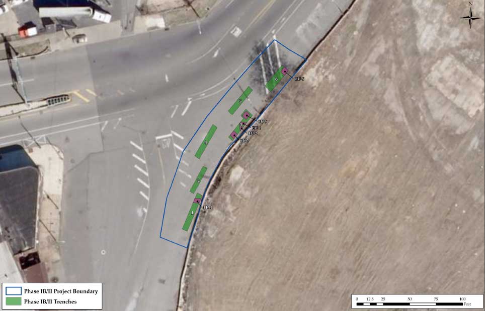
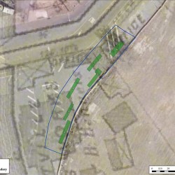
Improvements to I-95 in this portion of Section GR-1 at the intersection of Dyott Street and Richmond Street involve the replacement of the existing road surface, construction of a rain garden landscaping feature, the installation of deep multiple new utilities (with associated manhole/access facilities), and the removal of existing water, sewer, and electric lines. The Phase IB/II study area consisted of two distinct areas: Trenches 1–6 encompassed an area approximately 35 x 200 feet, situated along the northeast shoulder of the Dyott-Richmond Street intersection. The second study area (20 x 35 feet; Trench 7) was located approximately 250 feet north of Trench 6 at the west end of Schirra Drive, near its intersection with Richmond Street (Figures 1 and 2).
Study area conditions prior to the start of archaeological investigations were characterized by asphalt paving over Belgian block covering the entire study area. Concrete paving related to early-twentieth-century rail lines was exposed beneath the Belgian block in the west half of the test area (Figures 3 and 4). Sections of railroad tracks were visible on the street surface and are embedded in the concrete base. Wood railroad ties are also set in the concrete roadway base. The eastern boundary of the study area was defined by a chain link fence aligned along the far outer margins of Richmond and Dyott Streets. A privately owned, grass-covered lot—located on the east side of the fence, outside of the project area—likely contains additional well-preserved Dyottville Glass Works buildings and archaeological deposits (Figures 3–6).
Historic Background
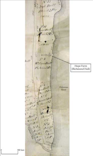
The land on the Delaware River lying north of Gunner’s Run was once part of a large country estate that William Ball, a Philadelphia merchant, purchased from Anthony Palmer in 1728 (Philadelphia County Deed Book G3:108). “Hope Farm” was calculated to contain 676 acres, plus the mud flats that stretched from the mouth of Gunner’s Run northward for a distance of 9,438 feet (about 1.8 miles) along the Delaware River. On a later map of the Ball estate, the mansion house is illustrated lying about 2,900 feet north of the mouth of Gunner’s Run, on a site overlooking the Delaware River. The Philadelphia and Reading Rail Road Company purchased the mansion and about 23 acres surrounding it in the middle of the nineteenth century, and the property became part of the Port Richmond rail yard (present day Conrail railroad yard) (Philadelphia County Deed Books RLL32: 522; GWC36: 465).
When William Ball died in 1740, his five living children—namely, William, Joseph, Ann, Samuel, and Mary—inherited Hope Farm in equal shares. William’s will specifies that Ann’s share was a lifetime estate that would pass down intact to her children (Fitler 1858:10; Philadelphia County Deed Book G3:108; Philadelphia Will Book F: 177). The estate of William Ball was brought before the Court of Common Pleas in order to make an equitable division among the five heirs. A group of 12 local landowners, who could impartially appraise the value of William Ball’s houses, gardens, and lands, undertook the partition (Figure 7).
In 1755, the court issued a partition of the land into 30 lots. Lot dimensions were drawn to maximize their value. For example, smaller lots were carved out of the valuable property between the riverfront and Point-No-Point Road (Richmond Street), and larger lots were created in the less-valuable area lying west of the road. Each heir was awarded between five and seven lots of differing values and in non-contiguous clusters on the estate. The lanes and landings were left open and not assigned to any of the heirs. William Ball, the eldest son, was awarded the mansion of Hope Farm on Lot No. 9, accompanied by 1,200 feet of shoreline. Mary Ball was awarded Lot No. 4, including a house on the banks of the Delaware—the only other building illustrated on the partition map aside from the mansion house. Joseph Ball was awarded Lot No. 2, just over four acres in size and situated on the southeast side of Point-No-Point Road, and the section of Hope Farm nearest the Gunner’s Run landing (Fitler 1858:10–12; Gibson 1856).
In 1756, Joseph Ball conveyed Lots 1 and 2 to his brother William (Fitler 1858:12). William Ball (1729–1810) was a merchant and planter who named his property “Richmond Manor” and named his house “Richmond Hall.” Detailed tax records from 1798 indicate that William Ball had nine tenants living on Richmond Manor. The area where these tenants lived became known as “Ball Town” or “Balton,” and was located on the north banks of Gunner’s Run along Point-No-Point Road (Jackson 1931:216).
Neither William Ball Jr. nor his brother Joseph had children, and Mary Ball died young and without issue, so that their shares in Hope Farm descended to the remaining heirs. Therefore, Hope Farm passed to the descendants of Samuel Ball, who had been lost at sea, and his sister Ann, who married John Gibson. Samuel Ball’s son, Joseph H. Ball, was born on July 4, 1776. He married Esther Hewson, the daughter of John Hewson, whose calico textile printing factory was built on the Ball estate near Gunner’s Run in the spring of 1774.
Martha Washington inspected the print works in November 1775 while on a visit to her Ball relatives. She commissioned John Hewson to print handkerchiefs with an image of her husband on horseback. The Washingtons later bought other textiles made at the Hewson plant (Reath 1931:27). John Hewson’s support of the Patriot cause extended to forming a company of militia men made up of his factory workers. In 1777, he fled the city with what equipment he could transport just ahead of the British army. British forces destroyed his factory and former
employees took the rest. Hewson was captured, but later escaped from imprisonment in New York. He arrived back in Philadelphia in 1778 and, the following year, set about restoring his printing business. He was aided by a £200 loan from Pennsylvania that allowed him to expand his calico printing and bleaching business (Gillingham 1928:101–103; Milano 2010:22–24).
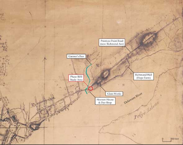
The 1798 direct tax list described the Hewson property as a two-story stone and brick dwelling (20 x 30 feet in size) with a dye shop fronting on Point-No-Point Road that was valued at $1,000. It was situated on a two-acre lot William Ball owned on the north side of Gunner’s Run, between Point-No-Point Road and the Delaware River (Figure 8). Earlier newspaper advertisements for his business indicate that his property at one time had also included a Bleach Yard (Brackman 2009:4). City directory listings and population census information consistently place John Hewson living and working on Point Road in Richmond Township. However, beginning in 1807, John Hewson’s address appears in city directories as Queen Street (now Richmond Street) in Kensington. The village of Kensington, when originally founded circa 1730, was centered in the area south of Gunner’s Run, between that stream and Cohocksink Creek (present-day Canal Street), but over time expanded into lands north of Gunner’s Run as far as the vicinity of present day Norris Street. Letters John Hewson wrote between 1813 and 1820 clearly indicate that he remained living on his property on Point Road north of Gunner’s Run until the time of his death (Lincoln 1904:209–227).
Hewson retired in 1810 and left the business in his son John’s hands. John Hewson Jr. carried on the business with the help of his brothers James and Robert. In 1814, the location of the calico printing factory, and of Robert Hewson’s residence, were described as Queen Street above Gunner’s Creek. John Hewson Jr.’s address is given alternately as “Queen above Point Bridge” and “Near the Glass House.” John Hewson Sr. died in 1821. His will left everything connected with the printing business to his son John (Gillingham 1928:104–105; Kite 1814:n.p.; Robinson 1804:109; Robinson 1816:217; Woodhouse 1807:n.p.; Woodhouse 1808:n.p; Woodward 1800:62).
In 1816, John Hewson Jr. became a partner in the firm Hewson, Connell & Company and announced that they would build a new glassworks on their lot which adjoined the old glassworks lot. John Jr.’s partner John H. Connell was probably a nephew. John Jr.’s sister Esther had married Thomas Connell in 1794 when she was 15 years old. John H. Connell was born the following year. When Esther married Joseph Ball in 1801, she appears to have brought two young sons from her previous marriage with her. John H. Connell was about 21 years old when he began making glass on the Hewson lot. City directories list his glass factory on “Queen near Gunner’s Run” from 1817 to 1822 (Linn and Egle 1880:9:83; McCarty & Davis 1822:n.p.; Robinson 1817:120; U.S., Bureau of the Census, Northern Liberties East, Philadelphia County, 1800:364; Philadelphia 12th Ward, 1860:202).
Directly north of the Hewson lot was the glass house and furnace known as the Philadelphia (or Kensington) Glass Works built by Robert Towars and Joseph Leacock in 1771. Towars was a skinner by trade and Leacock a watchmaker. The partners had purchased the lot for their factory from William Ball in October 1771. It measured 150 feet in width and lay between Bank Street and the Delaware River in the “town of Richmond.” Ball reserved ownership to a small, wooden frame, red-painted building on the lot (Philadelphia County Deed Book D6:266). This section of Bank Street was subsequently vacated in the first half of the nineteenth century to accommodate the expansion of the Dyottville Glass Works (Scharf 1884:2298) (Figure 9).
Towars and Leacock owned the glassworks for one year before selling it to another Philadelphia partnership made up of druggists, a brush maker, and a tanner. The deed conveying this lot specified that the property included a “glass house, furnace, melting potts, grinding mill, mill gears… with pans, plates, kettles, moulds, pipes, riddles, sieves, clay, and all utensils and materials belonging to the glass manufactory” (Philadelphia County Deed Book D6:266). The new owners built an additional furnace and manufactured bottles for eight years before closing during the British occupation of Philadelphia in 1777 (Scharf 1884:3:2299).
In 1780, the glassworks were sold to tobacconist Thomas Leiper. Following the sale, the glassworks were put back in operation, but only for a short period, during which glass production was sporadic. In 1798, Leiper’s property consisted of a 150-x-150-foot lot on the Delaware River, and contained a two-story wooden dwelling (15 x 15 feet) with a glasshouse. The entire property was valued at $600 and occupied by Christopher Triple (or Trippel). Thomas Leiper remained the owner for 20 years before he sold the glassworks to the partnership of Joseph Roberts Jr., James Rowland, and James Butland. They named their business the Kensington Glass Works. These partners also encountered problems with production, and in 1812 they were forced to auction off coal and an inventory of glass (Milano 2010:21; Philadelphia County Deed Books D6:268 and EF1:320; Scharf 1884:3:2299; Sives n.d.; U.S. Direct Tax List 1798).
Joseph H. Ball, John Hewson’s son-in-law, died in 1825, leaving as heirs: William White Ball (1802–1874); Joseph Ingles Ball (1807–1854); Benjamin B. Ball (1809–1865); George Bicknell Washington Ball (1814–1882); Charles Henry Ball (1817–1852); and Harriet Stiles Ball (1822–1902), who married Richard Dodson (Fitler 1858:14).
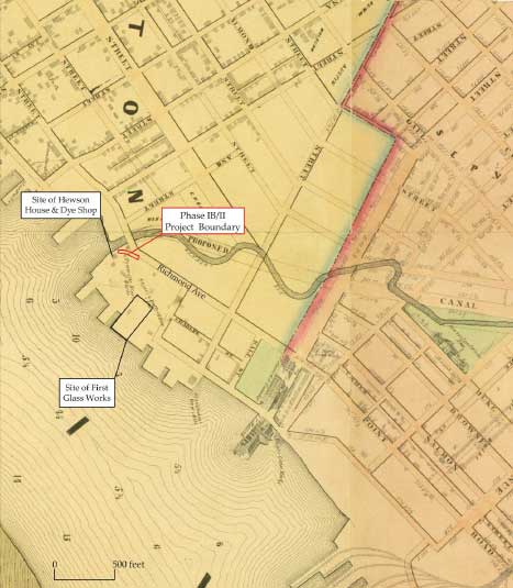
A partition of the Ball lands was made in the District Court for the City and County of Philadelphia in 1826, dividing the property into six shares. Joseph I. Ball was allotted the lot at the mouth of Gunner’s Run (Fitler 1858:15). In 1830, Joseph I. Ball, William W. Ball, and Benjamin Ball conveyed the lot lying on the north side of Gunner’s Run between the Point-No-Point Road and the Delaware River to Thomas W. Dyott for $20,000. The northern boundary of the lot was a new 50-foot-wide road named Rush Street. The lot encompassed land that had been previously occupied by the Hewson Calico Printing operations, the Hewson House, and the glass furnace Hewson, Connell and Company built in 1816—and may have continued to contain buildings dating to those earlier periods (Philadelphia County Deed Book AM10:7; Sives n.d.). Within a few years, Thomas W. Dyott had expanded his landholdings northward to James (later Plum) Street. This expansion included the acquisition of the 1771 Philadelphia/Kensington Glass House lot from James Rowland, in 1833, that included a total of three glass furnaces. Thomas W. Dyott renamed the glassworks the Dyottville Glass Works and there manufactured a variety of bottle forms, including those to contain his many patent medicine concoctions (Philadelphia County Deed Books AM37:747 and AM54:299) (see Figure 9).
Thomas W. Dyott was born in England about 1776 and arrived in Philadelphia sometime between 1796 and 1806. Very little is known of his early life in England, but he probably served an apprenticeship with a druggist. Once reestablished in Philadelphia, Dyott began what would eventually grow into a patent medicine empire by producing bootblack, which he sold and demonstrated (McKearin 1970:15). He appeared in a Philadelphia city directory for the first time in 1807, listed as the owner of a patent medicine warehouse at 57 South Second Street. He began advertising his boot blacking and patent medicines the same year (Democratic Press, 27 March 1807:4; Robinson 1807:n.p.). Dyott’s situation changed in 1809, when he moved to 116 North Second Street (between Race and Vine Streets) and opened a medical dispensary at the same address. His brother John also lived and worked at 116 North Second Street, selling his brother’s medicines (Robinson 1809:n.p.). Thomas listed himself as a physician in the Philadelphia city directories beginning in 1810 and adopted the credentials of “M.D. and druggist” (Whitely 1820:n.p.; Woodhouse 1810:n.p.). By 1814, he had expanded his property holdings, buying the former commercial and residential property of the merchant Abraham Wilt at the northeast corner of Second and Race Streets (Kite 1814:n.p; Scharf 1884:3:2299).
From the very beginning, Thomas W. Dyott had envisioned the sale of his patent medicines on a grand scale. By 1809, he had at least 14 agents in 12 towns and cities in seven states. Within a few years, his agents and newspaper advertisements reached nearly every corner of the country. Indeed, his use of advertising put him far ahead of his time and he became a nationally recognized medical figure. His brother John later moved to Charleston, South Carolina, set up his own practice in medicine and dentistry, and sold his brother’s patent medicines. John Dyott died in Charleston in 1827. By 1830, John’s widow Julia had moved her family in with her Dyott in-laws in Philadelphia and was listed in the city directory as working in a glass store at 143 North Second Street (City Gazette and Daily Advertiser, 10 July 1812:3; Desilver 1830:34; Motte 1816:8; Schirmer 1966:169; U.S. Bureau of the Census, Upper Delaware Ward, Philadelphia, 1830:439).
In 1829, Thomas W. Dyott’s brother Michael arrived in Philadelphia with his family to join the expanding Dyott business empire. In 1830, Michael Dyott was listed as a glass manufacturer and lived in Kensington. His family consisted of his wife and three children, yet the census enumeration listed 17 other people living in his household. Most of these other residents were young men and might have been apprentices in the Dyottville Glass Works (U.S. Bureau of the Census, Kensington, Philadelphia, 1830:257).
By 1833, the Dyottville Glass Works employed 300 people, of whom 225 were apprentices (The Mechanic, April 1834:139). Dr. Dyott supposedly bought large tracts of land along the river on which he raised dairy cows and grew vegetables to feed his workers. He established a labor commune based on his Methodist principals that strictly forbade alcohol and gambling, and closely monitored the activities of his employees. All his workers were required to participate in morning prayers, calisthenics, and school room lessons or lectures. Many of these meetings were held in the chapel Dyott built. He established a temperance society and promised extra rewards and compensations for those employees who demonstrated their piety and hard work. A system of fines was used to instill good behavior and support the Dyottville Apprentices’ Library. The creation of this community of laborers resulted in the area around the glassworks being named “Dyottville” (Scharf 1884:3:2299; Sives n.d.).
In 1836, Dr. Dyott established the Manual Labor Bank with an old friend, Stephen Simpson, at his former drug store at Second and Race Streets. He circulated his own bank notes extensively, but when confidence in his unchartered private bank became shaky during the economic collapse of 1837, he was compelled to redeem his notes. The bank failed in November 1837, and afterward Dyott declared bankruptcy and his creditors took him to court. He was convicted of fraudulent banking practices in a case that received nationwide attention, and was sentenced in 1839 to three years imprisonment in Eastern State Penitentiary. He was pardoned and released on May 10, 1841, after serving 18 months, and immediately was arrested for debt. After a two-week stint in the Debtor’s Apartment at Moyamensing Prison, he was released with the help of a friend who guaranteed the payment of his debts. In time, Dyott reestablished his apothecary business with his family on Second Street above Race Street. He lived until 1861, dying of “old age” at 84, and having regained his good standing in the community (Joyce 1919:224; Philadelphia Death Certificate, January 19, 1861; Scharf 1884:3:2299; Sives n.d.).
After Dr. Dyott’s business failure, the glassworks remained idle for a few years. The Lehigh Coal and Navigation Company acquired Dyott and Ball lands along the riverfront and built a coal depot that became Port Richmond (Figure 10). The company rented the former Dyottville Glass Works to Henry Seybert in 1842. Seybert sold his interest in the factory two years later and the glassworks was continued under the name of Dyottville Glass Works by a series of business partnerships until 1923 (Scharf 1884:3:2299; Sives n.d.).
Field Methodology
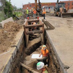
Archaeological testing within the study area was completed using a combination of machine trench excavations and hand excavation of test units of varying sizes within the trench floors. The size of individual units was based on the width and depth of the trench, the amount of space available between historic foundations, the location of existing utilities and other obstacles, and the size of shoring boxes available for deep trench excavations. A series of six trenches were positioned along the eastern margins of the Dyott-Richmond Street intersection to expose remains of the Dyottville Glass Works complex and to identify potential intact soil horizons that could contain evidence of Native American occupation along the north bank of Gunnar’s Run.
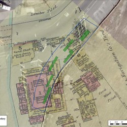
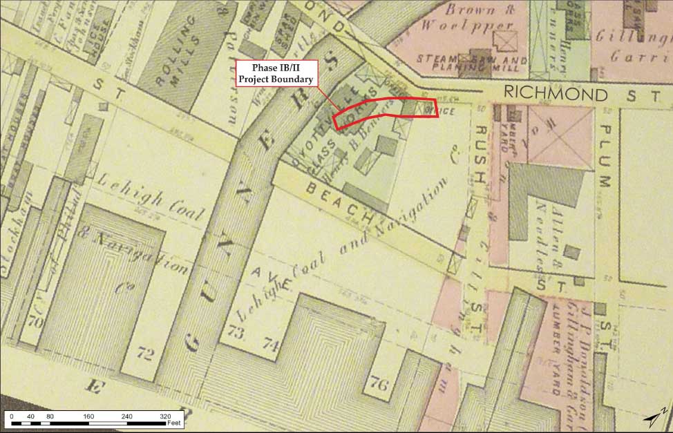
The location of the trenches was initially planned via georeferencing satellite images of the project site with the 1875 Hopkins and 1878 Hexamer maps of the city. Both of these historic maps contain detailed spatial information relating to the former glassworks and its associated buildings (see Figures 5 and 6). Trenches 1–5 initially measured 5 x 35 feet, and were arranged in a roughly linear north-south orientation along the eastern shoulder of Richmond Street to minimize obstruction of adjacent active traffic lanes. The trenches were placed in this configuration to identify the following resources: the main furnace structure of the 1870s-era glass house; ancillary buildings located along the northern boundary of the Dyottville property; evidence of structures pre-dating the Dyottville Glass Works complex; and potential undisturbed prehistoric horizons in the open space between buildings. Trench 6 (7 x 20 feet) was placed 30 feet north of Trench 3 to investigate the northern limits of the nineteenth-century Dyottville factory complex, identify potential undisturbed prehistoric soil horizons, and to aid in defining the transition from the floodplain wetlands of Gunner’s Run to a more established land surface. Trench 7, located 220 feet north of Trench 6, was placed at the west end of Schirra Drive near the intersection with Richmond Street to identify buildings related to the eighteenth-century Kensington Glass Works or other glass factory buildings known to have occupied this property, and to further characterize prehistoric soil horizons and their relationship to Gunner’s Run.
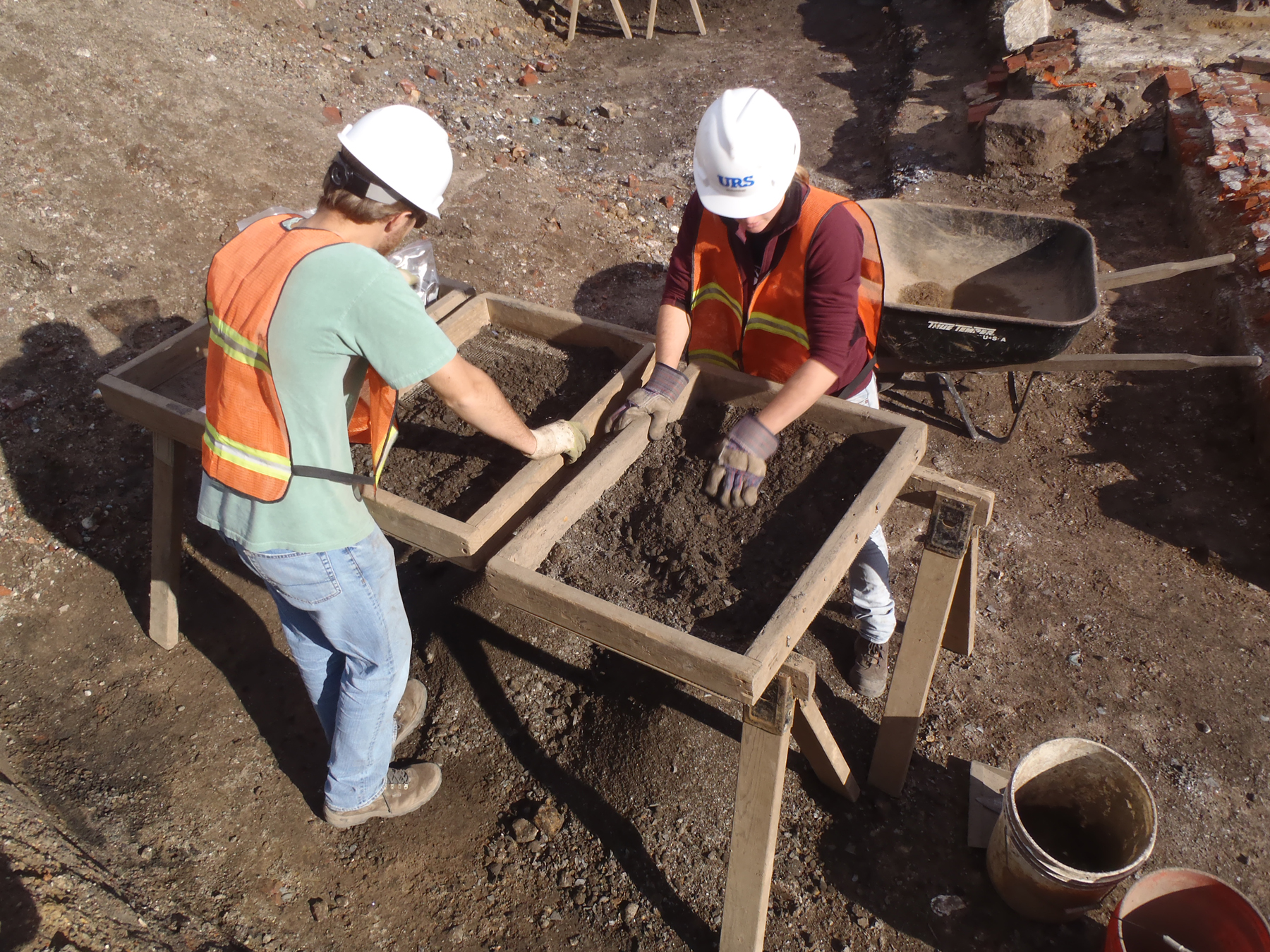
During site testing, excavated soils from intact soil horizons, as well as from identified features, were screened through ¼-inch hardware cloth. All recovered artifacts were retained in labeled plastic bags pending lab analysis and cataloging. Historic fill deposit soils were screened if it was determined that artifacts recovered would contribute to the overall interpretation of site stratigraphy or a specific fill deposit. Trench, excavation unit (EU), artifact, and feature provenience within the study area were established using total station survey equipment in concert with submeter-accurate GPS data collectors. All excavation data was fully documented through the use of standardized paper field forms, hand-drawn plan and profile maps, and high resolution digital photography. Due to the location of the excavation along the shoulder of Richmond Street, concrete barriers were placed around the perimeter of the excavation areas. Metal shoring boxes were placed in trenches that extended below a depth of 4 feet.
Field Results
Completion of the Phase IB/II testing at Site 36PH037 resulted in the excavation of seven machine-excavated trenches, with Trench 5 excavation discontinued due to an impenetrable concrete road surface. Remains of the former Dyottville Glass Works were exposed and consisted of a brick floor and probable furnace foundation within the main glass house building. Mica-schist stone foundations were also encountered that may be related to Thomas Dyott–era (circa 1810–1840) or earlier factory buildings. A probable nineteenth-century ground surface or factory floor was also exposed. Other historic features identified included three separate, probable early-twentieth-century, creosote-coated wooden conduits for electrical or telephone lines, an associated brick service manhole, and a brick sewer line possibly dating to the mid-tolate nineteenth century. Early twentieth-century rail lines and wood railroad ties embedded in concrete were exposed close to the road surface within the tested area. Deeply buried prehistoric artifact-bearing soil horizons containing Early through Late Woodland cultural deposits were identified in two test trenches (3 and 6). In Trench 3, Native American artifact deposits were recovered from multiple, intact, stratified soil horizons originally formed along the margins of Gunner’s Run. Descriptions of specific soil horizons, building remains and other features, and the recovered artifact assemblage are presented in the sections below.
Trench 1
Trench 1 measured 5 x 37 feet in size, was the southernmost trench excavated, and was located 10 feet west of the fence line bordering the adjacent property. The upper asphalt and Belgian
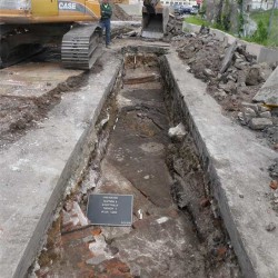
block road surface was approximately 1 foot thick and overlaid mixed fill deposits ranging in thickness from 2.5 to 3.5 feet and consisting of brick, stone, and concrete building rubble. A brick floor and stone and brick foundation remains were uncovered directly beneath the fill deposits (Figures 11 and 12). Sections of these foundations exposed in the trench profile
extended upward to within approximately 1.5 feet below current road grade. A thin lens of black cinders containing glass waste from the glass factory (primarily slag and crucible fragments) was identified directly overlying the brick floor. The brick floor (Structure 2) was embedded into a silt loam fill matrix, appeared to be one course thick, and exhibited a subtly undulating appearance, possibly a result of settling over time. The location of Trench 1 within the glass furnace structure suggests the brick likely represented the interior floor of the furnace area.
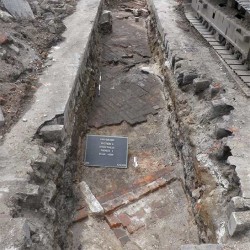
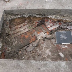
Brick structures (Structures 1 and 3) were identified at the north and south ends of the trench. Structure 1, at the south end of the trench, consisted of a partially exposed mortared brick foundation extending at least 10 feet north-south and continuing into the west wall of the trench. The foundation was set on a rough stone base extended at least six courses of brick above the surrounding brick floor. The top of the foundation appeared to be truncated during later road construction (Figure 13). Structure 1 was likely a portion of the glass factory heating furnace shown on the 1878 Hexamer map.
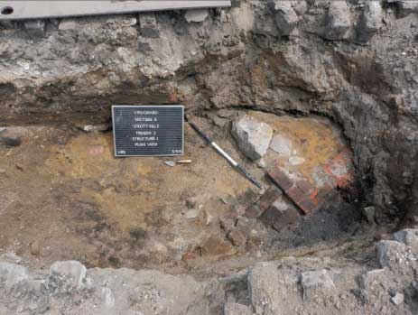
Structure 3 at the northern end of the trench, also partially exposed, extended 10 feet into the south end of the adjacent Trench 2. This structure was constructed of brick and stone and was
characterized by a flat surface forming a platform-like feature or possibly the base of an oven (Figure 14). Structure 3 was likely a section of the glass house furnace exterior wall or a tempering oven shown on the 1878 Hexamer map.
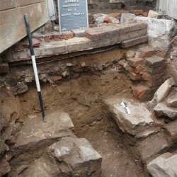
EU 4 was placed along the south side of Structure 3 and exposed the south side of the platform, revealing brick approximately three courses thick with stone edging. This portion of the
structure was set directly onto a sand base overlying silty sand and rubble fill, approximately 0.8 feet thick (Figure 15). Mottled silt fill mixed with mortar, stone, and brick fragments extended at least 2 feet below the rubble layer. A section of vertical brick wall was identified running along the south side of Structure 3 and may have formed the south supporting wall of the platform floor, or could have represented an entirely separate foundation wall associated with an earlier historic building.
The remains of a stone foundation apparently unrelated to Structure 3 were exposed approximately 1.6 feet below the bottom of the brick platform floor (see Figure 14 and 15). Two possible sections of wall were exposed, separated by mottled sand with pebbles fill. EU 4 was discontinued at a depth of 6 feet below the present road grade, with fill deposits and stone building rubble continuing further in depth and into the east and west walls of the trench. The stone foundation appeared to be related to an earlier building or construction episode, possibly associated with the Thomas Dyott–era glassworks or the Hewson calico printing works.
Trench 2
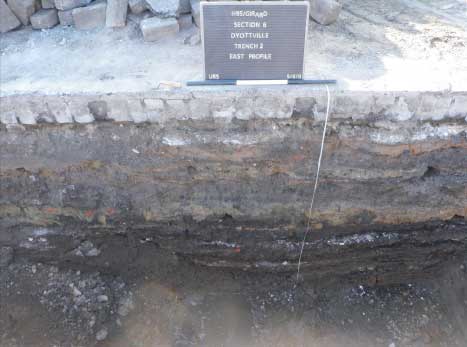
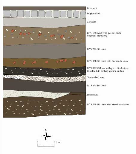
Trench 2, located northwest of Trench 1, measured 5 feet wide and extended 30 feet north-south. The majority of the trench revealed a similar stratigraphy to that found in Trench 1, and
consisted of mixed fill deposits, some 3.8 feet thick. These fill horizons were underlain by an apparent nineteenth-century artificial ground or living surface associated with the Dyottville
Glass Works complex. Deposits associated with this surface consisted of very compact black silt loam fill with crushed shell, and measured approximately 0.7 feet thick. Additional fill deposits consisting of silt loam with gravel inclusions extended to a depth of 6.8 feet below present road grade. Fill deposits appeared to continue further in depth; however, the presence of excessive groundwater prevented deeper testing (Figures 16 and 17). The northern portion of Structure 3 was exposed (described above) in the southern end of Trench 2 at a depth of approximately 3.4 feet below present street grade (Figure 18).
Trench 3
Historic Component
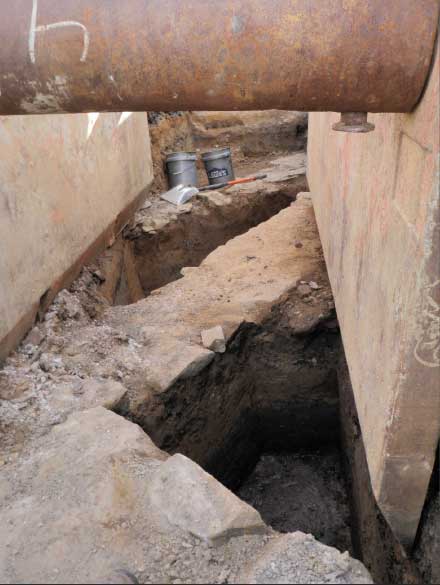
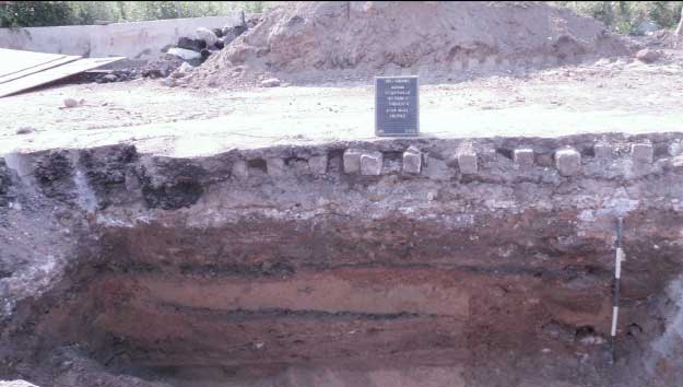
Trench 3 was located 39 feet north of Trench 2 and measured 5 x 35 feet in size (Figures 19 and 20). The location of this trench was moved 5 feet to the east due the presence of a water main,
and the north end of the trench was expanded 3 feet west to avoid a water pipe. Testing revealed a 1.4-foot-thick layer of asphalt and Belgian block overlying mixed fill deposits 6.4 feet thick
(building rubble, slag and coal ash deposits, and utility disturbances).
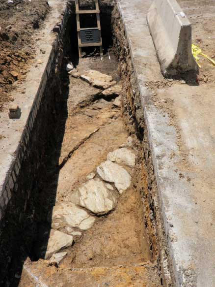
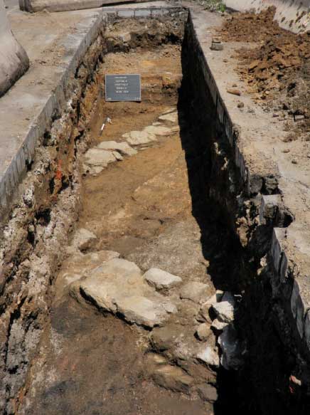
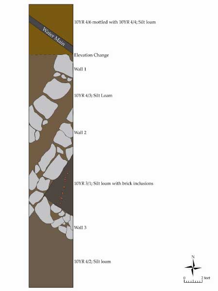
Three stone wall foundations were identified and partially exposed directly beneath the fill deposits in the north-central area of Trench 3, and are interpreted as being elements of the same
structure (Figures 21 and 22). Each wall was constructed of massive mica-schist blocks and was aligned on a diagonal axis through the trench. Wall 1 was 2 feet thick and was the northernmost wall in Trench 3, running in a southwest-northeast orientation. Wall 2, located 2.5 feet south of Wall 1, was similar in thickness and orientation. A builder’s trench approximately 3 feet wide and consisting of silt loam (10YR4/3) separated the two foundations. Wall 3 (1.5 feet thick) ran in a southeast-northwest orientation, with the northwest end abutting the south side of Wall 2.
Based on the 1878 Hexamer map, the identified walls appear to be foundations related to what was, at that time, the carpentry shop of the Dyottville Glass Works. These foundations appear to be of very similar construction as those earlier walls underlying Structure 3, in Trench 1, and likely date to at least the first half of the nineteenth century. Structures associated with these
foundations could have initially been built as part of the Thomas Dyott–era glassworks, the 1816 Hewson glassworks, or potentially the eighteenth-century Hewson calico printing works. If this is the case, then these structures likely served quite different functions during earlier periods of use.
Prehistoric Component
Four EUs were placed in Trench 3. Two initial, opportunistic excavation units (EUs 1–2) with irregular dimensions were placed to test potential intact soil deposits between and extending
below the foundation walls. EU 1 was located between Walls 1 and 2, and EU 2 was situated between Walls 2 and 3. Large quantities of Early–Late Woodland prehistoric artifacts were
identified in a series of stacked Ab soil horizons extending some 3–four feet beneath the bottom of the stone foundations. EU 3 and 5 (5 x 6 feet in size; unit size determined by available
shoring box dimensions) were then placed in the southern and northern ends of the trench, respectively, to more thoroughly explore and document these artifact levels. The completion of
these EUs produced a Native American artifact assemblage comprising some 2,488 total artifacts. Prehistoric lithic debitage constituted the single largest class of artifacts recovered
(n=1,612); however, various stone tools, prehistoric ceramics, fire-cracked rock (FCR), and other artifacts were abundant. A more detailed discussion of the stratigraphy and prehistoric cultural deposits identified within each of these EUs is provided below.
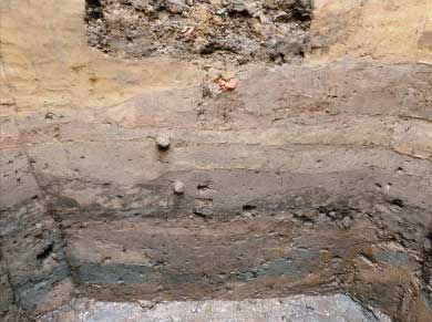
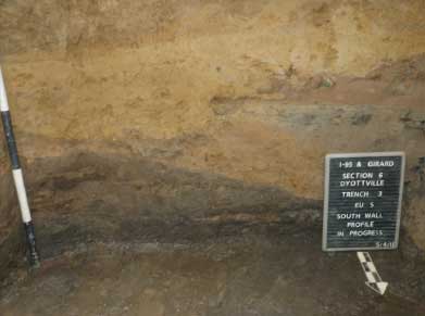
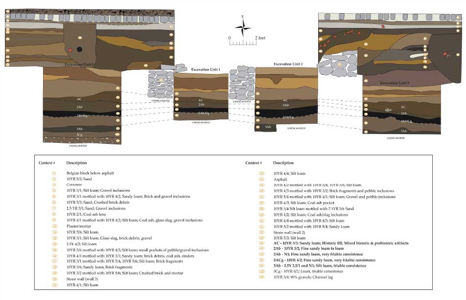
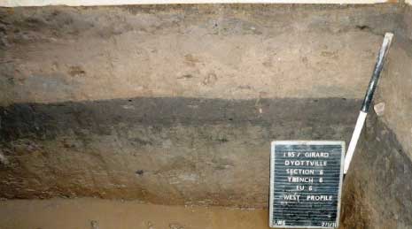
Excavation Units 1–3, and 5. Beneath the fill-related deposits, unit excavation in Trench 3 (EUs 1–3 and 5) identified intact soil horizons at approximately 6.5–7.5 feet below current street grade (Figures 23 and 24). Testing revealed a relatively uniform profile within Trench 3, consisting of a series of Ab- and Cg-horizon strata formed in the active Gunner’s Run floodplain (Figure 25 and 26). Each EU yielded a similar soil/sediment sequence, characterized by the presence of at least three buried living surfaces (Ab horizons) and intervening C-horizon deposits. In all cases, intact soil horizons were identified immediately below a historic fill episode (AC soils) marked by the presence of mixed historic and Native American artifacts. More detailed descriptions of these intact horizons are provided in Table 1 below.
According to geomorphologist Daniel Wagner, deeply buried soils identified in Trench 3 were likely formed during normal flood-driven alleviation from Gunner’s Run. In addition, some of
the vertical accretion that built the floodplain could have been in response to rising sea levels late in the Holocene period. At present, all intact soil horizons below the AC fill deposits are
thoroughly waterlogged, raising questions about their past ability to support Native American activity. However, it is entirely possible that current impeded drainage conditions are largely the
result of long-term and extensive historic period modification of this vicinity. By the same token, lower sea levels experienced during the earlier parts of the Holocene period may have left
this landform drier that present conditions suggest. Also, annual seasonal fluctuations may have resulted in episodic drying of the floodplain and created conditions more favorable to short-term, potentially task-specific activities to be carried out in close proximity to the active Gunner’s Run stream channel (Wagner, personal communication, August 22, 2011).
| Horizon | Thickness | Properties |
|---|---|---|
| AC | 0.25-0.55 ft | Dark brown (10YR 3/3) and brown (10YR 4/3) mixed sandy loam and loam friable consistence; historic fill |
| 2Ab | 0.8ft | Very dark grayish (10YR 3/2) fine sandy loam to loam; friable to very friable consistence |
| 2Ab/2Cg | 0.4/1.0 ft | Black (N1) and dark grayish brown (10YR 4/2) fine sandy loaml very friable consistence [Note: during excavation this stratum was designated a CA/C horizon, with the upper portion having a darker color than the overlying 2Ab, but otherwise exhibiting an indistinct transition from one to the next horizon. |
| 3Ab | 0.3 ft | Black (2.5Y 2.5/1 and N1) silt loam; organic fibers; friable consistence. |
| 3Cg | 0.4 ft | Dark grayish brown (10YR 4/2) loam; micaceous; friable consistence |
Significant numbers of Native American artifacts tentatively dated to the Early Woodland through Later Woodland culture periods were recovered from three distinct strata in this buried
soil sequence. Specific soil horizons identified as apparent prehistoric occupation surfaces consist of the 2Ab, 2Ab/2Cg (upper portion only), and 3Ab levels2. Native American artifacts contained in the overlying AC horizon are contained in what has been interpreted as a historic fill layer, and therefore have been redeposited from some other, possibly nearby, location. Historic artifacts within this matrix are few in number, highly fragmentary, and primarily temporally nondiagnostic in nature; as a result, no accurate dating of this layer has so far been possible. Each of these prehistoric horizons contained a variety of Native American cultural materials and showed no evidence of either vertical or horizontal sorting of artifacts by size of functional classification. Moreover, lithic raw material representation exhibited statistically significant variation between these horizons (Pearson’s Chi Squared Test; P<.0001), supporting the interpretation that the recovered artifact assemblages from these strata are likely associated with a succession of distinct Native American occupations of the Gunner’s Run floodplain. It should be pointed out that waterlogged conditions within these soil horizons have resulted in the preservation of significant quantities of botanical materials (wood, charcoal, plant fibers, etc.), suggesting that more thorough excavations are likely to yield important information related to the past natural ecology of the Gunner’s Run drainage, as well as potential floral and/or faunal-based Native American cultural materials. Charcoal samples were recovered from all artifact-bearing soils within Trench 3 and have been submitted for C-14 dating (results still pending). More detailed discussions of the prehistoric lithic artifacts recovered from Trench 3 are presented below.
Trench 4
Trench 4, located 10 feet northwest of Trench 2, was placed to straddle the northeast corner of the glass house building and the open courtyard area shown on the 1875 Hopkins and 1878
Hexamer maps. Trench 4 excavation also aimed to investigate the extent of potential prehistoric horizons. Trench 4 initially measured 5 x 35 feet, but was reduced to 5 x 15 feet due to the presence of a 2-foot-thick concrete bed that had to be removed using a machine-operated jackhammer. The concrete bed appears to extend west across the intersection of Dyott Street and Richmond Street, and is related to rail lines for the Cramp shipbuilding industry that encompassed this area in the early twentieth century. The rail lines remain extant and consist of large gage steel rails and wooden ties embedded into the concrete road bed. Machine excavation revealed multiple fill deposits beneath the concrete bed, extending to a depth of at least 4.5 feet below the present road surface (Figure 27). A bucket auger was used to determine the depth of fill and to confirm the presence of the prehistoric floodplain deposits previously identified in Trench 3. Intact soils were encountered at depth of 8 feet below the existing road surface and did not appear to be stratified, as in Trench 3.
Trench 5
Trench 5 excavation was discontinued due to the presence of a 2-foot-thick concrete road bed, rail lines, and wooden railroad ties embedded into the concrete. Investigation below the concrete road surface was carried out in Trench 4.
Trench 6
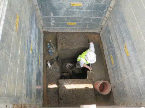
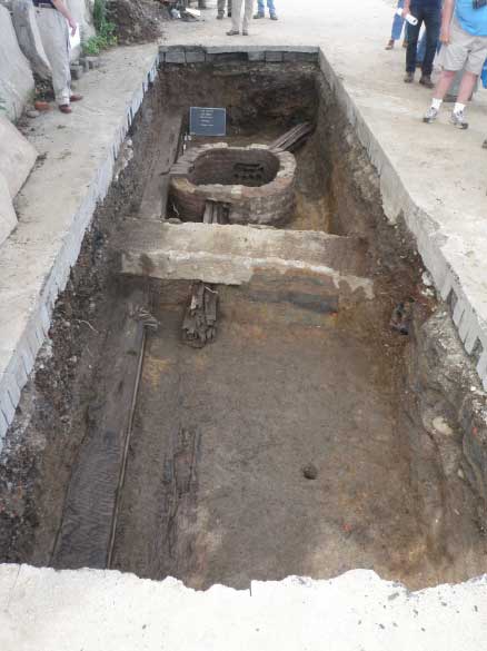
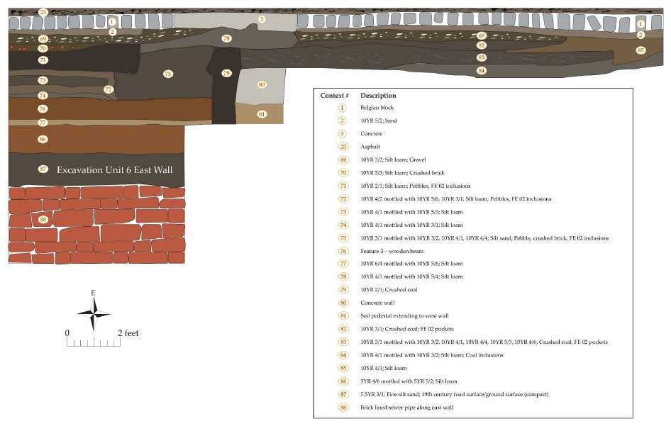
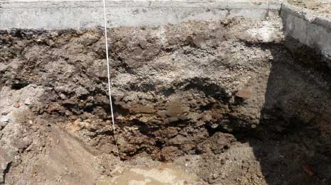
Trench 6 measured 7 x 27 feet and was located 30 feet north of Trench 3, along the northern boundary of the historic Dyottville property (Figure 28). Mixed fill deposits were encountered
beneath the asphalt and Belgian block road, and extended to depths of approximately 7 feet below the existing road surface. A rectangular brick shaft with rounded corners was exposed at approximately 2.5 feet below the present road grade, and measured 3.5 x 4.7 feet in size (exterior dimensions). Also at this elevation, a concrete footing or slab—20 feet long, 2 feet wide, and 1.4 feet thick—extending east-west across the trench, was exposed 9 feet south of the north trench wall (Figure 29). The shaft was constructed of mortared bricks arranged in alternating header and stretcher courses to a depth of 3.6 feet below the top course. Fill within the shaft consisted of lenses of silt loam with pebbles and brick fragments overlying a very compact silt loam floor.
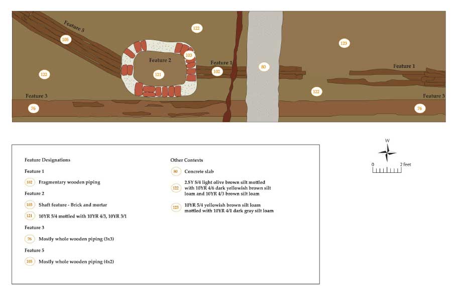
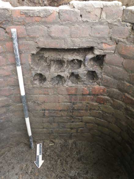
Openings measuring approximately 2.5 x 3 feet were identified on the north and south sides of the shaft, and into these openings were inserted multiple wooden pipes or conduits bundled
together within a wooden outer frame (Figure 30). The wooden conduits extended north and south of the shaft and probably contained telephone or electrical wiring. This type of conduit
was in common use in the late nineteenth and early twentieth centuries. The conduit on the south side of the shaft measured 1.2 feet wide, angled to the southwest, and continued into the
southwest corner of the trench. The north conduit measured 0.8 feet wide, extended straight out of the north wall of the shaft, and into the north wall of the trench. The brick shaft probably
functioned as a junction box or manhole providing access for installation of the telephone lines. It is likely that similar structures will occur throughout other portions of Richmond Street where this type of conduit was installed in the past. An additional 1-foot-wide wooden conduit was exposed along the east trench wall at a depth of 4 feet below road grade. This conduit ran the entire length of the trench and continued beyond the north and south walls.
Auger probing in the north half of the trench revealed additional fill deposits overlying intact Ahorizon soils at approximately 7.4 feet below the present road grade. EU 6 was then placed in the northern half of the trench to further investigate these deposits.
Excavation Unit 6
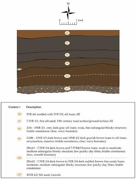
EU 6 revealed a buried soil profile that differed considerably with those recorded in Trench 3. Represented by upper Ab and ABb soils overlying weak subsoils, this profile lacked the stratified sequence found to the south and was indicative of stream terrace formation along Gunner’s Run (Figures 31–33). More interestingly, the limited degree of subsoil development indicates that this terrace was established sometime during the Late Holocene period, perhaps not more than some 4,000–5,000 years ago (B.P). As such, this terrace represents a (thus far) unique context within Philadelphia, in that it is the only known location where Native American artifact deposits have been identified within Holocene-age soil deposits (all other previously identified prehistoric sites in the city are contained within Pleistocene-age soils). This terrace additionally stands out in that it formed in direct association with the development of the adjacent Gunner’s Run drainage, not the Delaware River channel (Wagner, personal communication, August 22, 2011). More detailed descriptions of identified soil horizons are presented in Table 2 below.
| Horizon | Depth (ft) | Properties |
|---|---|---|
| 2Ab | 0-0.8 | Very dark gray (10YR 3/1) silt loam; weak, fine subangular blocky structure; friable consistence; clear, wavy boundary. |
| 2ABb | 0.8-1.0 | Dark brown (10YR 3/3) and dark grayish brown (10YR 4/2) loam to silt loam; structureless, massive, friable consistence; clear, wavy boundary |
| 2Bwb1 | 1.0-1.8 | Dark brown (7.5YR 3/4) and brown (7.5YR 4/3) loam; weak to moderate, medium subangular blocky structure; few patchy clay films; friable consistence; clear, smooth boundary |
| 2Bwb2 | 1.8-2.3+ | Dark brown (7.5YR 3/4) to dark reddish brown (5YR 3/4) fine sandy loam; moderate, medium subangular blocky structure; few patchy clay films; friable consistence |
Geomorphological examinations of the 2Ab and 2ABb soils within EU 6 indicated that they had not been previously impacted during historic plowing or other agricultural activities, and therefore have the potential to provide extremely significant information related to Native American lifeways and the specific occupation/exploitation of this landscape. In particular, horizontal artifact patterning and any features should be well preserved within these soils. As in Trench 3, all intact soils identified in EU 6 were thoroughly waterlogged; however, these current conditions are most likely the result of historic period modification of the surrounding ground surface. The absence of subsoil drainage mottling in these deposits suggests that this terrace setting would have originally been no worse than moderately well-drained, and therefore well suited for human occupation (Wagner, personal communication, August 22, 2011). The current waterlogged state of these soils has resulted in excellent preservation of organic materials with both the 2Ab and 2ABb horizons, and both charcoal and wood samples were recovered during testing. Selected samples of charcoal have been submitted for C-14 dating (results still pending).
Trench 7
Trench 7 measured 10 x 12 feet in size and was located along the north side of Schirra Drive, near the intersection with Richmond Street (Figure 34). A substantial, 2-foot-thick concrete floor was exposed beneath the asphalt and was removed with a machine-operated jackhammer. Mixed fill deposits were exposed beneath the concrete, extending to a depth of at least 10 feet below road grade. At this depth, water began to rapidly fill up the trench and the excavation was discontinued. This location was the site of a substantial Cramp ship yard building and boiler house dating to the early twentieth century, and appears to have been constructed to a depth that removed the historic A horizon and any potential evidence of earlier buildings. At this time, the full horizontal extent of this deep disturbance remains unknown. It is possible that intact archaeological deposits dating to both the historic and prehistoric periods could be located within the vicinity of Trench 7.
Prehistoric Artifact and Feature Summary
Trench 3
The initial test unit excavations in Trench 3 revealed the presence of an expansive, generally high-density prehistoric artifact assemblage across the entire trench (n=2,488) and extending outward an indeterminate distance in all directions. In terms of vertical distribution, the majority of artifacts (n=1,922) derived from the two uppermost Ab-horizon soil deposits (2Ab and upper portion of the underlying 2Ab/2Cg horizon), with a higher proportion of the artifacts being recovered in in the former context (n=1,016). Only EUs 3 and 5 were able to sample portions of the deeper 3Ab horizon due to safety concerns and groundwater infiltration; however, in both units, a marked increase in artifact count was associated with that stratum. No artifacts were identified within the gravelly deposits below the 3Cg horizon.
Native American artifacts are represented by pieces of lithic manufacturing debitage, a number of formalized (diagnostic bifaces) and expedient tool forms (utilized flakes, hammerstones, etc.), prehistoric ceramic sherds, and quantities of FCR (Table 3). Represented lithic raw materials include argillite, chert, jasper, quartz, quartzite, and sandstone (predominantly hammerstones and FCR). Lithic debitage constitutes the single largest artifact category (n=1612; 65%), represented in flakes from a range of stone tool reduction and manufacture, from the initial testing of unmodified raw material to the late stage of reduction. Jasper flakes comprised a majority of the debitage assemblage (n=744; 46%), followed by those manufactured from chert (n=382; 24%). FCR makes up the second largest artifact category (n=745; 30%).
| Group | Description | AC | 2Ab | 2Ab | 2Cg | 3Ab | 3Cg | Total |
|---|---|---|---|---|---|---|---|---|
| Debitage | Argillite | 71 | 88 | 26 | 9 | 3 | 197 | |
| Chert | 143 | 148 | 58 | 16 | 12 | 5 | 382 | |
| Jasper | 280 | 342 | 70 | 28 | 17 | 7 | 744 | |
| Quartz | 66 | 73 | 13 | 3 | 3 | 2 | 160 | |
| Quartzite | 27 | 61 | 30 | 7 | 3 | 1 | 129 | |
| Total | 587 | 712 | 197 | 63 | 35 | 18 | 1612 | |
| Cores | Chert | 4 | 1 | 5 | 1 | 11 | ||
| Quartz | 7 | 4 | 1 | 12 | ||||
| Jasper | 3 | 1 | 4 | |||||
| Total | 11 | 5 | 9 | 1 | 1 | 27 | ||
| Unifacial Tools | Notched Flake | 1 | 1 | 2 | ||||
| Scraper | 1 | 1 | 2 | |||||
| Utilized Flake | 4 | 4 | 2 | 2 | 12 | |||
| Total | 5 | 4 | 4 | 1 | 2 | 16 | ||
| Bifacial Tools | Biface | 12 | 8 | 3 | 3 | 1 | 27 | |
| Point, Side-Notched | 2 | 2 | ||||||
| Point, Stemmed | 3 | 3 | ||||||
| Point, Reworked | 1 | 1 | ||||||
| Point, Triangle | 1 | 1 | ||||||
| Point, Teardrop | 1 | 1 | ||||||
| Total | 16 | 12 | 3 | 3 | 1 | 35 | ||
| Cobble/Groundstone Tools | Chopper | 1 | 1 | 2 | ||||
| Hammerstone | 2 | 1 | 3 | |||||
| Netsinker | 1 | 1 | 2 | |||||
| Total | 4 | 1 | 1 | 1 | 7 | |||
| Prehistoric Ceramic | Grit-temper | 15 | 22 | 1 | 1 | 39 | ||
| Quartz-temper | 2 | 2 | ||||||
| Steatite-temper | 1 | 1 | 2 | |||||
| Unknown Rock-temper | 1 | 1 | ||||||
| Pipe Stem | 1 | 1 | 2 | |||||
| Total | 15 | 23 | 4 | 2 | 2 | 46 | ||
| Total FCR | 268 | 260 | 105 | 71 | 38 | 3 | 745 | |
| Overall Total | 906 | 1016 | 323 | 142 | 78 | 23 | 2488 |
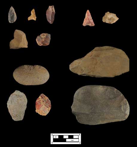
Cores, cobble/groundstone tools, and bifacial/unifacial tools are all represented. A total of 27 core fragments were identified, with a majority being procured locally as cobble cherts, jaspers
and quartz. In addition to the cores, several cobble and groundstone tools were recovered (n=7). These tools include two choppers, two netsinkers, and three hammerstones. Flaked stone tools from the site are represented by both bifacially and unifacially worked pieces. A total of 35 bifacial tools or tool fragments were recovered, including eight projectile points and several
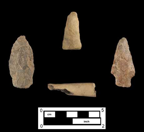
pieces (n=27) abandoned in the early through late stages of manufacture. Of the recovered points, five are stemmed Piedmont-variety examples (quartzite, jasper, and argillite), two are jasper triangles, and one was of tear-drop form (chert). Of the unifacial tools recovered (n=16), 12 of the specimens consist of utilized flakes. Also included are two notched flakes and two scrapers (Figures 35 and 36).
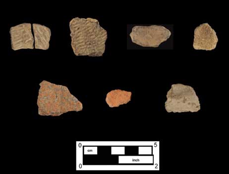
Prehistoric ceramics represent the last category of prehistoric artifacts recovered (n=46; 2%) (Figure 37). These specimens include 39 sherds of grit-tempered pottery (fabric-impressed and
undecorated), two quartz-tempered sherds (fabric-impressed), two sherds of steatite-tempered pottery, and one crushed rock-tempered body sherd (argillite). Two clay pipe stem fragments were also identified.
Trench 6
Trench 6 also produced evidence of an expansive, generally high-density prehistoric artifact deposit (n=475) extending outward an indeterminate distance in all directions. In terms of their vertical distribution, prehistoric artifacts derived evenly between the 2Ab horizon (n=184; 39%) and underlying 2ABb horizon (n=188; 39.5%) soil deposits. No artifacts were identified below the upper 10 centimeters of the 2ABb horizon.
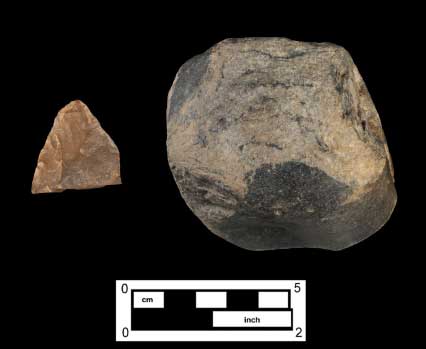
Native American artifacts are represented by pieces of lithic manufacturing debitage and quantities of FCR. However, only a small number of formalized (bifaces) and expedient tool forms (utilized flakes, hammerstones, etc.) were recovered (Table 4). No prehistoric ceramics were recovered from EU 6. Represented lithic raw materials include argillite, chert, jasper, quartz, quartzite, and sandstone (predominantly FCR). Lithic debitage constitutes the single largest artifact category (n=333; 70%), represented by flakes from a range of stone tool reduction and manufacture, from the initial testing of unmodified raw material to the late stage of reduction. Chert (n=103; 31%), argillite (n=101; 30%), and jasper (n=101; 30%) flakes comprised a majority of the debitage assemblage. FCR constitutes the second largest artifact category (n=138; 29%). Cores, cobble/groundstone tools, and bifacial/unifacial tools are minimally represented (Figure 38). One quartz core was recovered in the uppermost stratum. Additional tool finds include two jasper biface fragments in the 2Ab horizon and one sandstone hammerstone in the 2ABb horizon.
| Group | Description | 2Ab | 2ABb | 2Bwb1 | Total |
|---|---|---|---|---|---|
| Debitage | Argillite | 43 | 37 | 21 | 101 |
| Chert | 40 | 48 | 15 | 103 | |
| Jasper | 52 | 34 | 15 | 101 | |
| Quartz | 6 | 6 | 2 | 14 | |
| Quartzite | 14 | 14 | |||
| Total | 141 | 139 | 53 | 333 | |
| Cores | Quartz | 1 | 1 | ||
| Total | 1 | 1 | |||
| Bifacial Tools | Biface Fragment | 2 | 2 | ||
| Total | 2 | 2 | |||
| Other | Hammerstone | 1 | 1 | ||
| Total | 1 | 1 | |||
| Total FCR | 40 | 48 | 45 | 138 | |
| Overall Total | 184 | 188 | 88 | 475 |
Within EU 6, two possible prehistoric features were identified. Features 6 and 7 were identified as potential semi-circular post features within 2ABb-horizon soil deposits. Located approximately 2 feet from each other, both features consisted of charcoal and decaying wood, and exhibited very similar overall dimensions (0.3-foot and 0.35-foot diameters, respectively). Each feature extended to a depth of 0.2 feet into the underlying 2ABb-horizon soils. Charcoal and wood samples from each feature were collected and have been submitted for radiocarbon dating (results still pending).
Conclusions and Recommendations
Phase IB/II archaeological investigations within a portion of the Dyottville/Cramp Site (36PH037) have yielded significant information about a location that has played a vital role in
the early history of the Kensington and Port Richmond neighborhoods, and that for more than 100 years was associated with Philadelphia’s important glass industry. Excavation within the Dyottville factory footprint exposed architectural elements of the late nineteenth-century glass furnace, brick floor, and possible tempering oven or foundation wall. A probable nineteenth century ground surface relating to the glassworks was identified, along with stone foundations of ancillary buildings along the northern boundary of the glass factory complex. Excavations also exposed building foundations beneath the late-nineteenth-century glass furnace that could relate to earlier occupants of the site. More deeply buried archaeological deposits within the site could be associated with the late-eighteenth-century Hewson Calico Print Works, the home of John Hewson, the Hewson, Connell & Company Glass Works (founded 1816), and/or the early nineteenth- century glassworks complex of Dr. Thomas W. Dyott.
Despite the long industrial history associated with the present study area, substantial gaps exist in terms of what is known about the general development of industry in this location and regarding the organization and operation of individual business ventures. Data-recovery investigations have the potential to produce significant data relating to a number of research issues, including the manner in which the study area landscape was progressively altered over time to accommodate successive historic industrial operations, the specific spatial and physical makeup of the various enterprises that occupied this location, and the technological organization of these industries. In addition, artifact deposits and features preserved with the study area might generate previously unknown information regarding the products manufactured here over time and, in some cases, about the lives of individuals that lived and worked within these grounds.
Phase IB/II excavation also revealed the only known stratified prehistoric site thus far identified in Philadelphia. Preserved intact beneath the historic levels, the prehistoric component provided compelling evidence of an expansive, generally high-density prehistoric occupation along the north bank of Gunnar’s Run, and has been provisionally dated to the Early through Late Woodland periods. Native American occupation horizons within these tested portions of the site have already yielded significant information regarding the pre-Contact occupation of
Philadelphia, and therefore are considered eligible for listing on the National Register of Historic Places. More intensive data-recovery investigations of this component have the potential to
reveal preserved intrasite artifact patterning, additional intact features and related artifact deposits, and both floral and faunal cultural materials not normally recovered from prehistoric
sites in this vicinity.
Based on prior discussions with archaeologists from PennDOT and PHMC, this portion of the Dyottville/Cramp Site (36PH037) is considered eligible for the listing in the National Register of Historic Places. Disturbances associated with GR-1 construction activities—including the replacement of existing road surfaces, the construction of a rain garden feature, and the installation of multiple new public utility lines and access points—are expected to impact the study area to depths ranging from approximately 3 to 14 feet below present road grade. Given
these impacts, URS recommends that Phase III data-recovery investigations be required within accessible portions of the site. A detailed data-recovery plan specifying the proposed study area for Phase III investigations, the methodologies to be employed in those excavations, and the research issues to be addressed will be presented in a companion document to this management summary.
Interpretations and recommendations contained in this document pertain only to those portions of the site that fall within the specified Phase IB/II study area (Figure 39). Portions of the
construction project that are potentially archaeologically significant outside these limits will need to be separately tested and evaluated if they are to be impacted during the course of the I-95 GIR Improvement Project.
References
Anonymous
c. 1777 Map of Philadelphia and vicinity during the British occupation. Historical Society of Pennsylvania Map Collection, Call number: Of610ca.1777b.
ArcGIS Online
2011 Electronic document, http://services.arcgisonline.com/arcgis/services, accessed August 2011.
Brackman, Barbara
2009 John Hewson: Legend & Life. Part 2, Hewson’s Life. Electronic document, http://www.barbarabrackman.com/2bHewsonLife.pdf, Accessed August 22, 2011.
City Gazette and Daily Advertiser [Charleston, South Carolina]
1812 “Dr. J. Dyott,” 10 July 1812:[3].
Democratic Press [Philadelphia, Pennsylvania]
1807 Pro Bono Publico. 27 March:[4].
Fitler, Alfred
1858 Brief of title to The Ball Estate, situate in that part of the City of Philadelphia, late the Districts of Richmond and Kensington, fronting on the River Delaware. Unknown publisher, Philadelphia.
Gibson, James, Esq. (Prothonotary of the Court of Common Pleas)
1856 Copy of the Original Plan annexed to the Partition of the Real Estate of William Ball deceased as the same remains filed of Record in the [Court of Common Pleas for the City and County of Philadelphia]. Which Partition was made and Returned to said Court by Samuel Morris Esq. Sheriff and an Inquest of said County by Sheriffs Return dated February 27, 1755 and duly Confirmed at March Term 1755 and ordered to remain firm and stable forever. Surveyed 1754 & 1755 by Joseph Grover.
Gillingham, Harrold E.
1928 Calico and Linen Printing in Philadelphia, The Pennsylvania Magazine of History and Biography, Vol. 52, No. 2 (1928), pp. 97-110.
Joyce, John St. George
1919 Story of Philadelphia. Unknown publisher, unknown location.
Lincoln, James Minor
1904 The Papers of Captain Rufus Lincoln of Wareham, Mass. Privately printed by the author.
Linn, John B. and William H. Egle, M.D., editors
1880 Marriage Record of First Presbyterian Church of Philadelphia, 1702-1745 and 1760-1803. Record of Pennsylvania Marriages Prior to 1810, Volume II. Pennsylvania Archives, Second Series, Harrisburg.
McCarty & Davis
1822 The Philadelphia Directory and Register for 1822.
McKearin, Helen
1970 Bottles, Flasks and Dr. Dyott. Crown Publishers, Inc., New York.
Milano, Kenneth W.
2010 Hidden History of Kensington & Fishtown. The History Press, Charleston, SC.
The Mechanic [American Periodicals Series Online]
1834 Miscellany. April:139.
Motte, Abraham
1816 Charleston Directory and Stranger’s Guide for the Year 1816. Printed by the publisher, Charleston, South Carolina.
Reath, Nancy Andrews
1931 A Philadelphia Calico-Printer, Bulletin of the Pennsylvania Museum, Vol. 26, No. 138 (Jan. 1931), pp. 25-28.
Robinson, James
1817 Robinson’s Original Annual Directory for 1817.
1808 The Philadelphia Directory for 1808. Printed by W. Woodhouse, Philadelphia.
1804 The Philadelphia Directory for 1804. Printed by John Oswald, Philadelphia.
Scharf, J. Thomas, and Thompson Westcott
1884 History of Philadelphia, 1609–1884 in Three Volumes. I. H. Everts and Company, Philadelphia.
Schirmer, Jacob Frederic
1966 The Schirmer Diary, The South Carolina Historical Magazine, Vol. 67, No. 3 (Jul., 1966), pp. 167-171.
Sidney, J. C.
1849 Map of the City of Philadelphia Together with all the surrounding Districts, including Camden, N.J.[From Official Records, plans of the district surveyors & Original Surveys by J. C. Sidney, civil engineer & surveyor]. Smith & Wistar, Philadelphia.
Sives, Kevin A.
n.d. Dr. Thomas W. Dyott – A True Renaissance Man. Electronic document http://www.manheim1762.org/files/Revised_Dr._Dyott_-_2.pdf
Stafford, Cornelius William
1800 The Philadelphia Directory for 1800. Printed by William W. Woodward, Philadelphia. Wagner, Daniel P.
2011 Personal communication to Senior Archaeologist Douglas Mooney regarding geomorphological interpretations of soils examined within the Dyottville Site; Aug. 11.
U.S. Bureau of the Census
Var. Population Schedules for Philadelphia County. [Ancestry.com].