Introduction
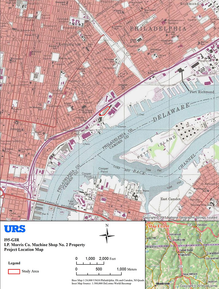
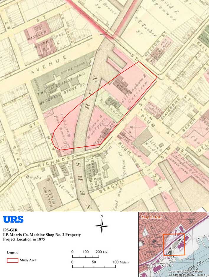
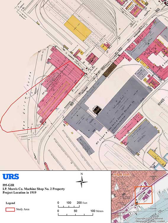
The following management summary documents the preliminary findings of Phase IB/II archaeological excavations performed as part of the I-95/GIR Improvement Corridor Project for the Pennsylvania Department of Transportation (PennDOT), Engineering District 6-0. URS Corporation (URS) performed these investigations within a portion of the GR-1 – GR-3 section of the larger project area, and specifically within a study area that extended along the west side of Richmond Street, from Dyott Street to the former Norris Street alignment (Figure 1). This location was formerly the site of the I. P. Morris Co. Machine Shop No. 2 building, and part of the larger William Cramp & Sons Ship and Engine Building Company industrial complex (Figure 2). (Note that archaeological deposits discovered during this investigation have not yet been assigned an official site name nor received a state site number designation).
Planned improvements to I-95 within the current study area and its immediate vicinity include the construction of two new traffic ramps (Ramps A and E), installation of erosion and sediment control retention basins (sediment traps), and the construction (during GR-4) of multiple rain garden landscaping features and associated water management structures. This management summary and accompanying data-recovery plan describes the findings, interpretations, and recommendations of archaeological investigations within the approximate easternmost one-third of the larger Machine Shop No. 2 property, where intact Native American deposits and a handful of historic industrial building remains were documented. The remaining two-thirds of the property—presently capped by thick concrete slabs and therefore unavailable for archaeological testing—will be investigated, and potentially subjected to data-recovery excavation, as they become available.
All archaeological testing was conducted in accordance with Section 106 of the National Historic Preservation Act of 1966, as amended; 36 CFR Part 800, particularly sections 800.4, and 800.5; the Section 106 Programmatic Agreement of 2010; as well as the Pennsylvania Historical and Museum Commission (PHMC), Bureau of Historic Preservation (BHP) Guidelines for Archaeological Investigations in Pennsylvania (2008). The objectives of the Phase IB/II effort within the current study area were to: 1) determine the presence/absence of any potentially significant prehistoric and/or historic archaeological deposits, building foundations, and other features; 2) assess the significance and integrity of archaeological deposits; and 3) provide recommendations regarding the potential eligibility of identified archaeological deposits for listing in the National Register of Historic Places. PennDOT and Pennsylvania Historical and Museum Commission (PHMC) archaeologists have determined that the site is eligible for listing in the National Register of Historic Places, and that Phase III data-recovery investigations of Native America resources identified in the current test area will be necessary.
Study Area Description and Subsurface Conditions
The study area discussed in this document lies within a large open parcel of land bounded by Richmond Street on the east, Delaware Avenue to the south, I-95 to the west, and Girard Avenue
to the north. Until 2011, this larger property contained the massive I. P. Morris Co. Machine Shop No. 2 and No. 3 buildings, a Jack-and-Jill Ice Cream building (near the southern boundary), and the Standard Feather building (at Girard Avenue). At this time, only the partially demolished Standard Feather building is still in existence, and until a few months ago, the rest of the study area was capped by the thick concrete slab floor of the machine shop factories, along with large fill demolition debris piles and irregular sections of asphalt driveway and parking areas.
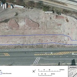
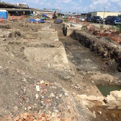
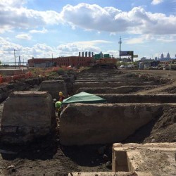
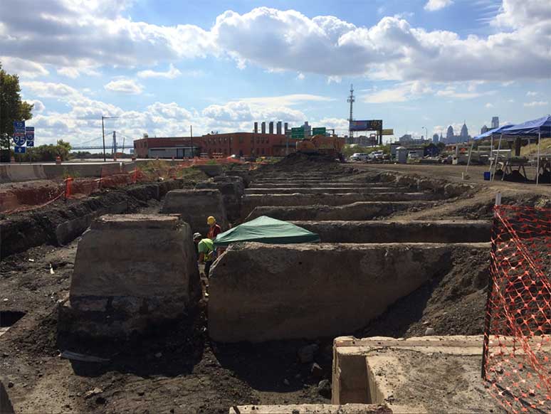
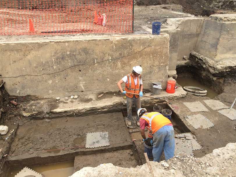
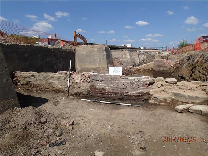
Archaeological testing within the Machine Shop No. 2 property began in April 2014, when roadway construction crews removed a section of concrete slab floor along the west side of Richmond Street to allow the creation of a temporary sediment trap. The area this removal made accessible measured approximately 60 x 640 feet in total size (0.88 acres), and this space constitutes the current test area for archaeological investigations within this larger property (Figure 3). Subsequent machine-assisted excavation within this test area revealed the presence of deep nineteenth- and twentieth-century mixed fill deposits, along with multiple reinforced concrete piers and walls associated with the foundations of the former Machine Shop No. 2 building (Figures 4 and 5). Mixed fill deposits extended to depths of between 6 and 7 feet below the surface and capped extensive intact historic ground surface soils (A horizon) contained in open spaces between the Machine Shop No. 2 foundation elements.
Historic Context
Early Owners of the Founding of Kensington
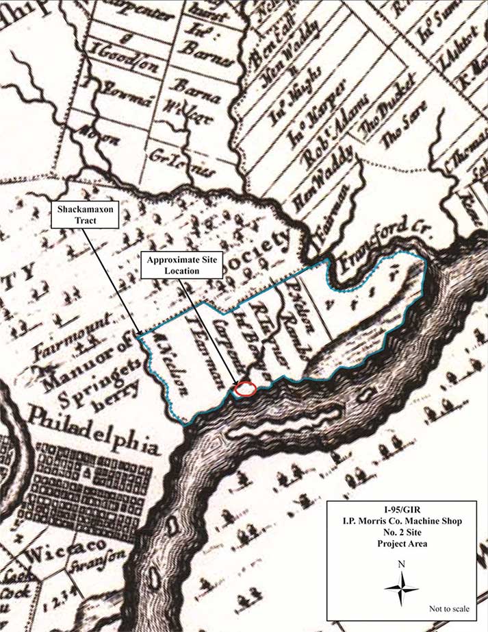
During the early historic period, the land encompassing the present study area was part of a 1,600-acre parcel within the colony of New Sweden and patented to Peter Larsson Cock (Cox) on June 5, 1664 (Figure 6). Known as the Shackamaxon Tract, this estate was handed down to Peter’s son Lars (Lasse) Cock, as well as interrelated members of the Nilsson (Nelson) and Rambo families (Milano 2009a). Members of these families established a series of scattered farmsteads along the banks of the Delaware River between Cohocksink Creek and the modern neighborhood of Port Richmond, although the exact locations of their simple homes have never been firmly established.
Between 1697 and 1699, a Barbadian, Captain George Lillington, purchased four contiguous properties—amounting to a total of 582 acres—from the descendants of the original Swedish Shackamaxon Tract occupants. This property was located on the west bank of the Delaware River and immediately north of the small, meandering stream known as Gunner’s Run. It is doubtful that Lillington ever occupied this land, however, because he sold the parcel just a few years later, in 1704, to a fellow Barbadian named Anthony Palmer for the sum of 500 Barbados pounds. Palmer moved to this property by 1709, built for himself a fine manor house and outbuildings, and called his new estate Hope Farm. Over the next 25 years, Palmer gradually acquired or purchased additional lots of land and was able to enlarge his country seat to a total of 676 acres. In 1729, Palmer sold Hope Farm to local merchant and silversmith William Ball and moved into the former Fairman estate on the south side of Gunner’s Run. Once established, he began to divide his new land and sell individual parcels to prospective buyers. The settlement that emerged in this location was given the name Kensington (Milano 2013).
Eighteenth-Century Industrial Center and the Establishment of Balltown
Next door, at the former Hope Farm, William Ball erected a grand house on his newly acquired land, which he renamed Richmond Hall. Ball’s home was located a short distance northeast of
the current study area, on land now owned by Conrail. In subsequent years, the wider area encompassing Ball’s estate would be known as Richmond or the Richmond Precinct, and in the nineteenth century became the neighborhood of Port Richmond (Mooney et al. 2012).
William Ball died 10 years after purchasing Hope Farm and left behind five children, the eldest of whom, William Jr., inherited most of the land. While much of the land contained within the Richmond Hall estate was submerged beneath the Delaware River with each high tide, areas bordering the north banks of Gunner’s Run had been drained, parceled into lots, and offered for rent and development as early as 1740 (Mooney et al. 2012). Although these lots were advertised as now being “fit for Buildings” (Pennsylvania Gazette, July 3, 1740), it does not appear that any substantial development occurred in the vicinity of the study area until the 1770s. In 1771, Robert Towars and Joseph Leacock rented from the younger William Ball “a piece of ground on the east side of Bank Street one hundred feet front and extending to the river” (Scharf and Westcott 1884: 2298). They established the successful Philadelphia Glassworks, which Thomas Dyott later purchased in the early nineteenth century and made famous under his own name (Milano 2008: 32; Scharf and Westcott 1884: 2298–2299).
In another development, Benjamin Franklin—a cousin of Leacock by marriage (Milano 2008:32)—invited a man named John Hewson to relocate from England to Kensington to avoid the wrath of King George for his revolutionary political views. Hewson accepted the offer, left England in 1773, and established a calico printing works at Gunner’s Run, adjacent to Towers and Leacock’s glassworks, the following year (Scharf and Westcott 1884: 2316). With clientele such as Martha Washington, who favored Hewson’s prints and went so far as to commission a kerchief for her husband, the area was bound to grow and did so steadily (Remer 2002: 18). Hewson, a soldier as well as a businessman, returned from the Revolutionary War a hero and ran the company until retirement in 1810, when his son John Hewson Jr. took over the business (Remer 2002: 19).
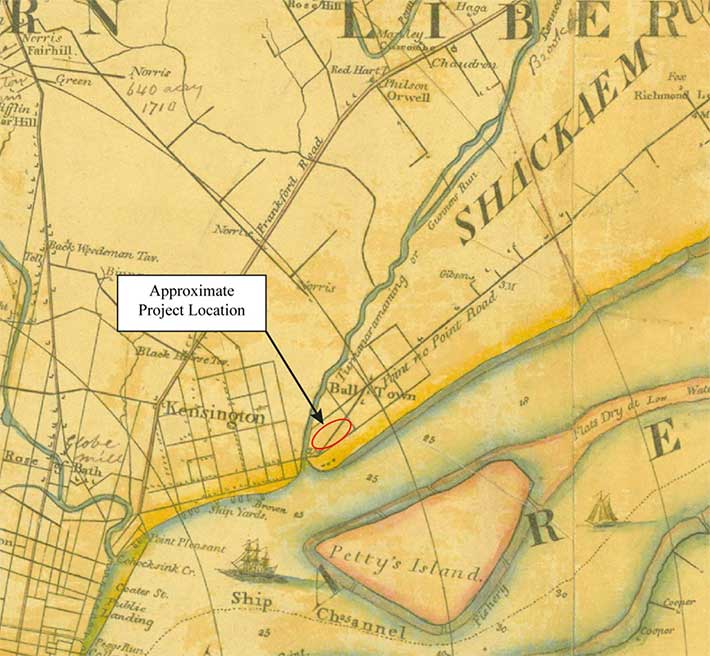
The establishment of these early industries along the north shore of Gunner’s Run gave rise to a small community known locally as Balltown. Likely consisting of no more than a smattering of simple homes, and populated primarily with individuals and families employed in the adjacent glass and calico works, this community was established by the late eighteenth century and
appears to have been centered near the mouth of Gunner’s Run and along a portion of Point-No-Point Road (Richmond Street), near the present study area (Figure 7). By the 1830s, however,
this little hamlet had been subsumed by the Dyottville settlement established around Dr. Thomas Dyott’s glassworks, and disappeared from historical memory. During its brief lifetime, Balltown represented the northernmost extent of development in the vicinity of Gunner’s Run (Westcott 1895: 482).
The Aramingo Canal and Industrial Development in the Late Nineteenth Century
Despite the establishment of Balltown and Dyottville, more intensive development of the current study area vicinity did not occur until the middle of the nineteenth century and the construction of the Aramingo Canal. This canal was conceived, and ultimately built, by a group of men who owned land along the banks of Gunner’s Run. In 1847, they incorporated themselves as the Gunner’s Run Improvement Company and sought to convert the marshy environs of that stream into a navigable waterway that would attract both industrial and residential development to the area. Initial plans for the canal were bold and called for the construction of a 100-foot-wide waterway that would extend a distance of some five miles, from the Delaware River to Frankford Creek. This waterway was not intended to function as a normal canal, however, but rather would accommodate the free sailing of ocean and river-going vessels, be built with timber wharves on either bank, and function as an inland extension of the port of Philadelphia. Unfortunately, this vision was never fully realized, due to lack of capital funding, and in the end the canal was only ever completed as far inland as Lehigh Street (Mooney et al. 2012).
Despite the problems besetting the Aramingo Canal, its partial construction did succeed in bringing industrial development to this location. Among the various enterprises established along its banks were glassworks, lumber yards, and rolling mills, along with stove, lead, and tile works. Within the current study area, the businesses created included two lumber mills and a single glass manufactory (Figure 8). The Brown and Woelpper Sawing and Planing Mill and Lumber Yard was located at the corner of Richmond Street and Ash Street, with the Aramingo Canal bisecting the complex diagonally, and was established around 1850. The company manufactured doors, sash, moulding, and millwork, and employed approximately 70 men until its demise at around the turn of the twentieth century (Hexamer 1879). At the northern end of the test area, near Norris Street, the Gillingham & Garrison and Co. Saw Mill was established in 1855 and became a major industrial enterprise during the Civil War. The firm continued to operate at this location, under several names, until the late 1890s (Mooney et al. 2012).
In between these two lumber enterprises, an apparently short-lived glassworks occupied the middle portion of the current test area. Available evidence suggests that this industry was first built sometime around 1849–1850, by a partnership consisting of two men named B. P. Hunt and F. G. Heye. So far, all efforts to determine more information about these two individuals and where they came from, or to establish connections between them and the larger glassworks nearby, have produced no results. An advertisement published in 1850 indicated that this factory manufactured a wide variety of products, including “Druggists, Chemicals, Lamp, Table and other varieties of Flint Glassware, cut, pressed and plain, white and colored” (Public Ledger, July 2, 1850). The ad also suggests that this factory may have been aligned in some way or in association with the chemical company Powers & Weightman, which was responsible for introducing quinine to the United States. A subsequent listing for this enterprise in the 1851 city directory indicated that it operated under the name Kensington Glassworks (McElroy 1851: 203).
It is not known how long this glassworks was operated by Hunt and Heye, but historic maps indicate that by 1875, the plant was owned by Henry B. Benners and had been incorporated into
his Dyottville Glassworks complex (see Figure 8). Active glass production appears to have ceased in this facility shortly after 1875, however, and by 1878, the plant is depicted as being used exclusively for the storage of finished carboys. This industrial complex continued to stand until sometime after 1910, when it and the properties on either side were demolished to make way for the I. P. Morris Co. Engine Shop No. 2 building.
Twentieth-Century Development
At the turn of the twentieth century, as the Aramingo Canal was being converted into a sewer and removed from the cityscape, the land within the study area was acquired by the William Cramp & Sons Ship and Engine Building Company and incorporated into that corporation’s massive industrial complex along the Delaware River. In conjunction with the Cramp expansion, Richmond Street was widened to the west between the Aramingo Canal and Cumberland Street. This widening involved the demolition of approximately 80–85 feet of the land immediately bordering Richmond Street. In 1901–1902, the first of a series of new machine shop buildings were constructed by Cramp near Norris Street. A second round of construction, at the site of the present test area, was subsequently carried out a decade later.
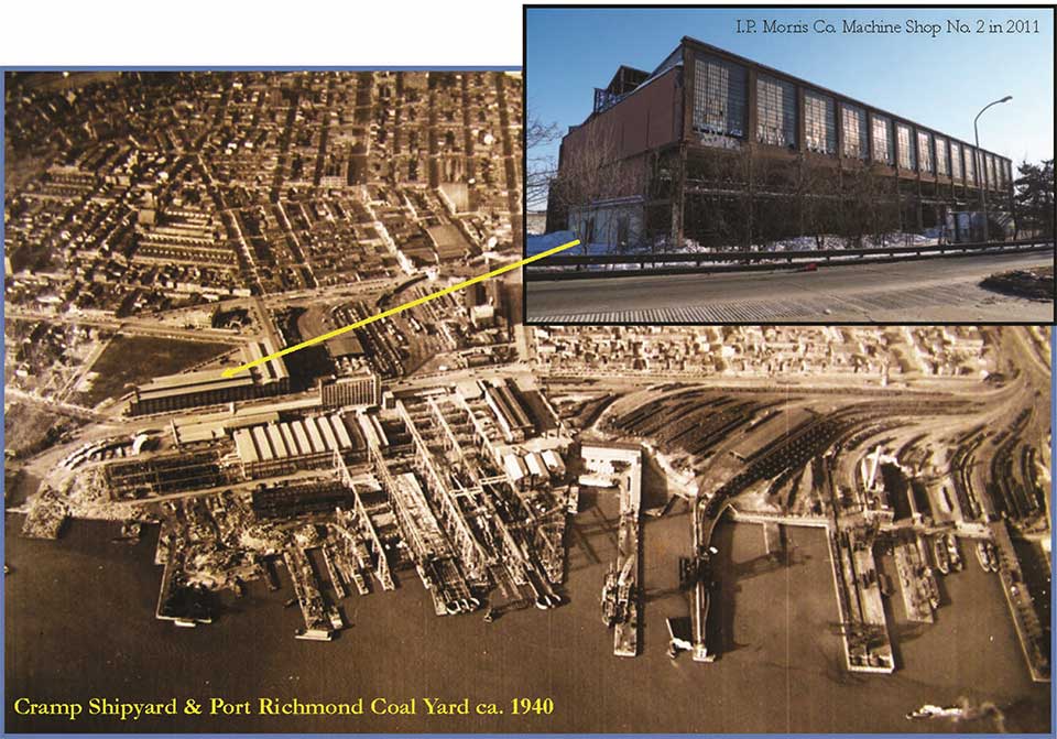
The factory built at the location of the test area was designated the I. P. Morris Co. Machine Shop No. 2, and was completed in 1911–1913 (Figure 9). The I. P. Morris Co. was a subsidiary of the larger Cramp Shipbuilding Company and Machine Shop No. 2 was added to meet an increased demand for hydraulic turbine engines for hydroelectric projects.
In 1915, the American Ship and Commerce Corporation, a national maritime conglomerate controlled by New York financier W. Averill Harriman, purchased the William Cramp & Sons Ship and Engine Building Company in an effort to combine shipbuilding with a transatlantic shipping line. The new owner retained the Cramp & Sons name and made extensive capital improvements to the shipyard in response to a World War I–related shipbuilding boom. Due to numerous naval contracts, it is estimated that Cramp & Sons produced one-quarter of the naval tonnage used in World War I. Cramp’s war output included 46 destroyers, four tankers, three transports, and two freighters. During the years 1910–1915, Cramp employed an average of 5,000 employees; by 1917–1918, the workforce had expanded to 10,000 individuals.
After the war ended, the demand for hydraulic machinery remained high, and in response, a third Morris machine shop was built on the site. Machine Shop No. 3 was built adjacent to Shop No. 2, on the Dyott Street side of that building. The primary purpose of the new building was the machining of parts for hydraulic turbines.
The Cramp shipyard began a slow decline in the early 1920s due to the passage of a naval treaty limiting the construction of new naval vessels. By 1927, American Ship and Commerce had
decided to close the shipbuilding portion of the business and place the non-marine operations, including I. P. Morris Co., under a holding company, Cramp-Morris Industrials. As a result, the Cramp & Sons shipyard, founded in 1830, was officially closed in October 1927. The hydraulic turbine practice likely remained active throughout the 1920s, and in 1931, Baldwin Locomotive Works purchased Cramp-Morris Industrials.
The U.S. Naval Department revived the Cramp shipyard during World War II. Due to outstanding claims, the original Cramp & Sons firm was dissolved and a new corporation, Cramp Shipbuilding Company, was established in cooperation with the Navy. Production surged during the war and the shipyard was again buzzing with a workforce in the thousands. Machine Shop No. 2 was part of the Turret and Machine Shops complex and was dedicated to machining parts for naval ships, including large gun turrets (Abbot 2010).
At the end of World War II, the shipyard was again closed and became the property of the U.S. government. In the years since, the buildings on this site were leased to various tenants for
storage and warehousing. Machine Shop No. 2, the last of the former William Cramp & Sons Ship and Engine Building Company structures left standing, was finally demolished in conjunction with PennDOT’s I-95/GIR project in 2011.
Field Investigations
Methodology
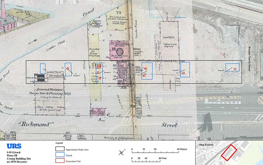
Phase IB archaeological examinations within the current test area were confined to areas containing intact historic ground surface soils (A horizon), and were completed using a combination of machine trench excavations and hand excavation of 5-foot-square test units. A total of eight machine trenches were initially excavated, two of which (Trenches 1 and 2)
encountered impenetrable concrete foundations directly beneath the slab concrete floor and were discontinued. Six trenches (Trenches 3–8), located approximately 60 to 100 feet apart and measuring between 15 x 35 and 35 x 50 feet in size, were excavated to a depth of approximately 7 feet below the concrete floor level, exposing the historic A horizon/ground surface (Figure 10).
The purpose of these initial test trenches was to provide an indication of the extent of historic resources and intact A-horizon soils extending from the Gunner’s Run stream channel, at the
southern end of the available test area, to the northern end near the former Norris Street alignment. Excavation units were placed in Phase IB Trenches 3, 5, 6, 7, and 8 to determine the presence/absence of intact soils and associated artifact deposits. A total of 11 5-foot-square units were excavated in these trenches during the Phase IB testing, and these established that intact ground surface deposits containing varying quantities of predominantly Native American artifacts were present throughout almost the entire test area (see Figure 10).
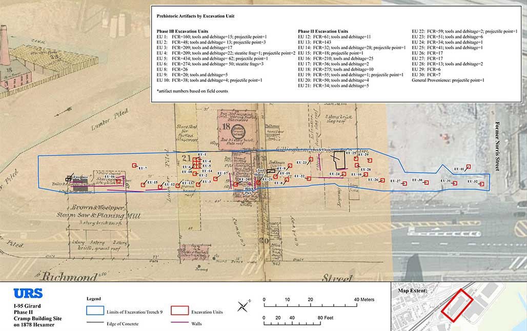
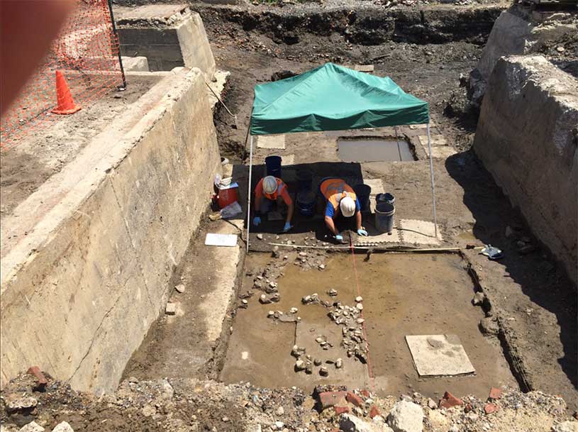
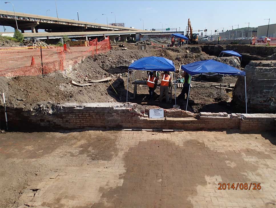
The Phase II investigations involved the excavation of an initial north-south oriented trench, designated Trench 9, which extended the entire length of the accessible test area (640 feet). Subsequently, a series of 5-foot-square test units were excavated at 25-foot intervals along the length of Trench 9 to document the distribution of Native American artifacts throughout this space and to search for any evidence of preserved features. A total of 21 standard interval units were placed along the length of the trench (Figure 11).
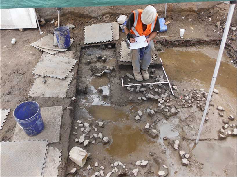
During site testing, excavated soils from intact soil horizons, as well as from identified features, were screened through ¼-inch hardware cloth. All recovered artifacts were retained in labeled plastic bags pending lab analysis and cataloging. Historic fill deposit soils were screened if it was determined that artifacts recovered would contribute to the overall interpretation of site stratigraphy or a specific fill deposit. Trench, excavation unit (EU), artifact, and feature proveniences within the study area were established using total station survey equipment in concert with submeter-accurate GPS data collectors. All excavation data was fully documented through the use of standardized paper field forms, hand-drawn plan and profile maps, and high resolution digital photography.
Results of the Phase IB/II Investigation
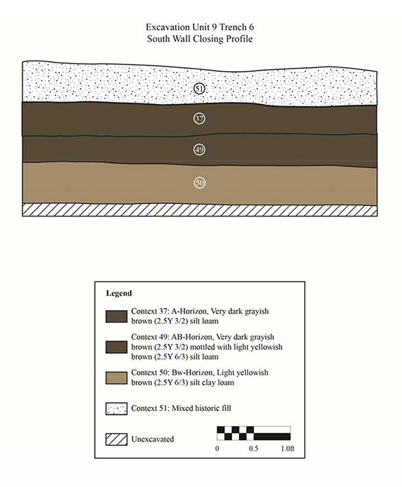
Phase IB Excavation Units 1 through 11 revealed intact A-horizon soils preserved beneath approximately 6 feet of mixed nineteenth- and twentieth-century fill deposits. A-horizon soils were generally exposed at approximately 4 feet above sea level (asl), generally measured about 0.4 feet thick with a silt-loam interface of equal dimensions, and immediately overlaid intact B-horizon sediments. Intact soils throughout all sections of the test area were found to be completely inundated with groundwater due to the low-lying nature of these deposits, and their
proximity to the former Gunner’s Run stream channel. In addition, groundwater here was also subject to regular tidal fluctuations, with water ponding between 4 and 8 inches deep during periods of high tide. Given the perpetually wet soil conditions at this location, periodic pumping of groundwater was required to allow excavations to be completed.
Historic and prehistoric artifacts were recovered from intact A-horizon soils in all locations except Trench 4, which contained culturally sterile estuarine sediments deposited along the margins of Gunner’s Run. These sediments were exposed directly beneath fill deposits at an elevation of 2 feet asl. In Trench 3, Units 1 and 6—and in other areas of the project site—the A horizon was intermittently truncated and/or disturbed (Figures 12 and 13).

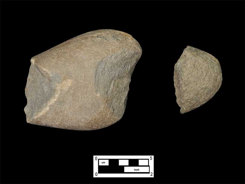
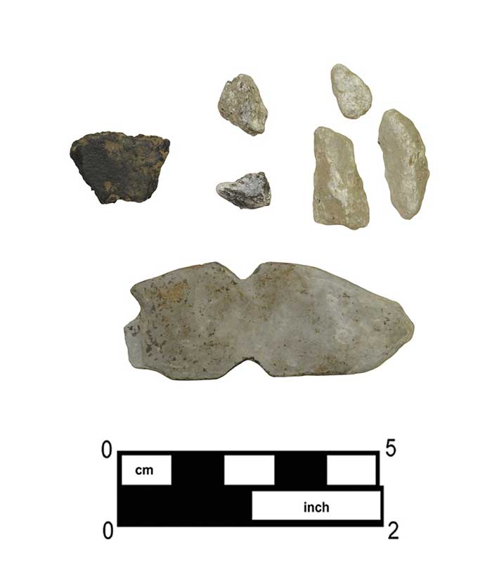
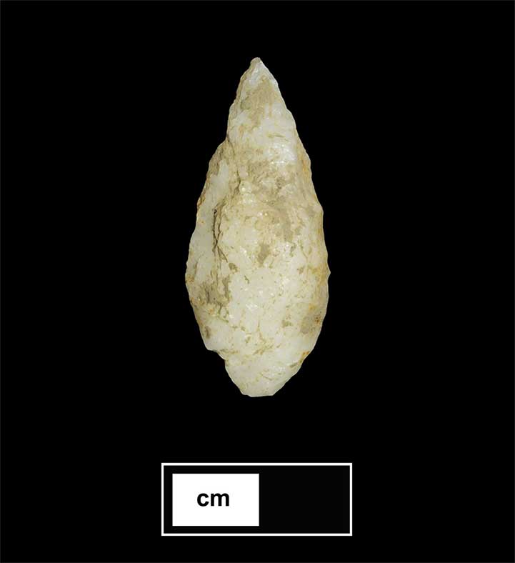
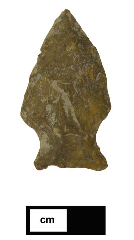
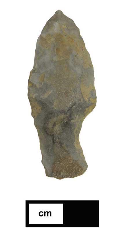
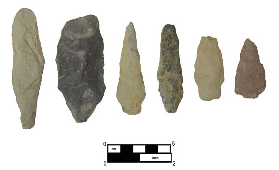
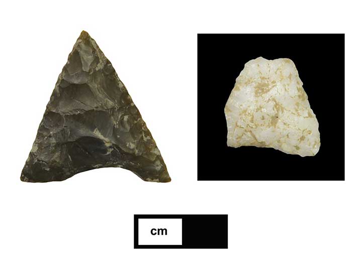
Phase IB testing resulted in the recovery of a total of 1,599 Native American artifacts (based on field counts). The greatest proportion of these consist of fire-cracked rock (FCR) (n=1,418/88.7%; refer to Figure 10). A particularly dense concentration of FCR was exposed in Trench 3 in Units 1, 4, 5, and 6, located at the west end of the trench (Figures 14–16). Additional artifacts recovered include lithic debitage, bifaces, and flake and cobble tools (n=173), diagnostic projectile points (n=8), and steatite fragments (n=4). Lithic artifacts were fashioned from a variety of raw materials, including jasper, quartzite, quartz, argillite, shale, and chert (Figures 17–24), and have been tentatively dated, based on diagnostic forms, to the Late Archaic through Late Woodland culture periods.
Phase II investigations consisted of 21 additional 5-foot-square units (12–32), located in Trench 9 (see Figure 11); these excavations resulted in the recovery of a total of 1,258 Native American artifacts (field counts). As in the case of the Phase IB findings, the Phase II artifact assemblage is overwhelmingly dominated by FCR (n=1,159/92.1%). Additional recovered artifacts include 98 flaked/cobble tools and debitage, as well as five projectile points. Diagnostic points recovered from both the Phase IB and II field efforts include examples of fishtail (quartzite), stemmed Lackawaxan/Piedmont variants (argillite), triangular (chert, quartz), and teardrop (quartz) projectile types. Phase II investigations revealed that artifacts were not evenly distributed throughout the test area, but rather were concentrated in that portion roughly extending from Schirra Lane south. Significantly smaller quantities of prehistoric artifacts were recovered from the northernmost units (24–30), with no prehistoric artifacts recovered from Units 7, 11, 31, and 32.

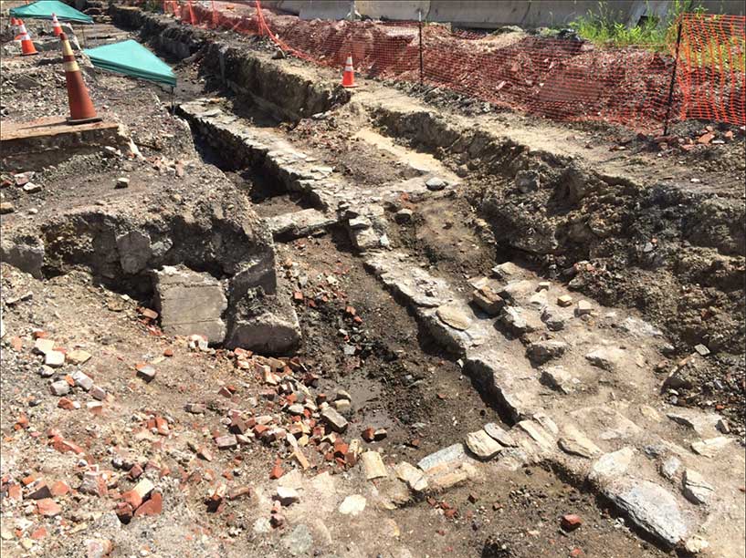
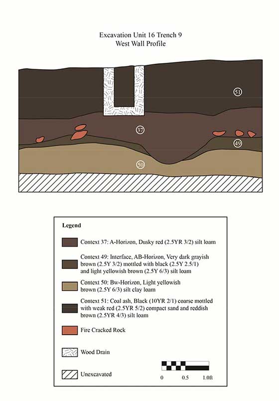
The excavation of Trench 9 also revealed a number of partial building foundations related to three nineteenth-century industrial buildings: the Brown and Woelpper Steam Saw and Planing Mill, the Hunt & Heye/Benner Flint Glassworks, and the Gillingham & Garrison and Co. Saw Mill (see Figures 11 and 25–27). Figure 28 shows the west wall profile of Excavation Unit 16, located within the foundations of the Brown and Woelpper Saw Mill foundations at the southern end of the site. In this unit, the A horizon was identified directly beneath historic fill and a wood drain presumably used to remove water from the lower foundations of the building. Additional recovered historic resources consisted of two separate deposits of stoneware wasters and redware vessels found directly overlying the A horizon at the southern end of the test area, and almost certainly related to local ceramic production. Although quantities of historic artifacts (building materials, ceramics, glass vessel fragments) were identified in A-horizon soils, along with objects of Native American manufacture, those deposits appeared to consist of a random accumulation of midden refuse and were not interpreted as representing a potentially significant resource.
Conclusions and Recommendations
Phase IB/II investigations of a portion of the larger I. P. Morris Co. Machine Shop No. 2 property revealed intact A-horizon soils beneath 6 feet of historic fill. Prehistoric artifacts such as fire-cracked rock (FCR), lithic tools, debitage, cobble tools, and projectile points were recovered from 28 of 32 excavation units, and indicated that Native American occupation of the site was largely concentrated in the southern half of the test area. The prehistoric component provides compelling evidence of an expansive, generally high-density prehistoric occupation along the north bank of Gunner’s Run, and has been provisionally dated to the Late Archaic through Late Woodland periods (circa 3000 B.C.–A.D. 1600). High concentrations of FCR and a variety of tool forms suggest that activities carried out in this location focused on the repeated acquisition and processing of locally available plant and animal resources, rather than intensive long-term group settlement.
Historic resources identified within the test area consisted of foundations and ancillary buildings related to three nineteenth-century industrial enterprises: two sawmills and a glass factory.
Testing identified no potentially significant artifact deposits in association with these structures. The building ruins themselves are not considered to be archaeologically significant, although
they do have the potential to provide information regarding the overall form of these particular enterprises. This is particularly true of the Hunt and Heye/Benner Flint Glassworks, about which comparatively little is known. While no intact glass production artifact deposits have yet been identified, portions of this glass factory—including the furnace—could be preserved in an area immediately to the east of the current test area. URS recommends that future exploration of this area should focus on documenting the form and manner of construction of the furnace, if it still survives, as well as efforts to determine if intact artifact deposits are preserved in this part of the factory.
Based on prior discussions with archaeologists from PennDOT and PHMC, Native American artifact deposits identified in this portion of the I. P. Morris Co. Machine Shop No. 2 property are considered eligible for listing in the National Register of Historic Places, and will be impacted by planned current and future construction activities. Given these impacts, URS recommends that Phase III data-recovery investigations be carried out within the higher density areas identified in the southern half of the test area. A detailed data-recovery plan delineating the proposed limits of Phase III investigations, the methodologies to be employed in those excavations, and the research issues to be addressed will be presented in a companion document to this management summary.
Interpretations and recommendations contained in this document pertain only to those portions of the I. P. Morris Co. Machine Shop No. 2 property that fall within the current Phase IB/II test area. URS additionally suggests that portions of this property that contain potentially archaeologically significant remains outside these limits will need to be separately tested and
evaluated if they will be impacted by construction activities.
References
Abbot, Martin
2010 I. P. Morris Co. Machine Shop No. 2 Historic Resource Survey Form. Historic structures documentation prepared for the Pennsylvania Department of Transportation and the Pennsylvania Historical and Museum Commission.
Hexamer, Ernest and Son
1879 Brown and Woelpper’s Sawing and Planing Mill and Lumber Yard, Hexamer General Surveys, Vol. 15. Ernest Hexamer, Philadelphia.
Hills, John
1808 Plan of the City of Philadelphia and Its Environs. John Hills, Philadelphia.
Holme, Thomas
1681 A map of the improved part of the Province of Pennsilvania in America: begun by Wil. Penn, Proprietary & Governour thereof. London.
Hopkins, G. M.
1875 City Atlas of Philadelphia, Vol. 6, Wards 2 through 20, 29 and 31
McElroy, A.
1851 McElroy’s Philadelphia Directory for 1851. Philadelphia, Edward C. & John Biddle, publishers.
Milano, Kenneth W.
2008 Remembering Kensington and Fishtown: Philadelphia’s Riverward Neighborhoods. The History Press, Charleston, South Carolina.
2009 Shackamaxon Timeline. Electronic document, http://kennethwmilano.com/page/Encyclopaedia/Shackamaxon/ShackamaxonTimeline/tabid/209/Default.aspx, accessed October 2014.
2013 Anthony Palmer, Hope Farm, and the Founding of Kensington. Encyclopaedia Kensingtoniana website, http://kennethwmilano.com/page/Encyclopaedia/18thCenturyKensington?AnthonyPalmerandtheFoundingofKensington/tabid/114/Default.aspx
Mooney, Douglas B., Patricia E. Miller, and Ann Marie DiLucia
2012 Archaeological Investigations of the Aramingo/Gunner’s Run Canal (36PH0153), I-95/GIR Improvement Corridor Project, Philadelphia, Pennsylvania. Report prepared for
the Pennsylvania Department of Transportation. URS Corporation.
Pennsylvania Gazette, July 3, 1740
Public Ledger, July 2, 1850
Remer, Richard
2002 Old Kensington. In Pennsylvania Legacies, Historical Society of Pennsylvania, Philadelphia 2: 9–16.
Sanborn Map Company
1916 Insurance Maps of Philadelphia, Pennsylvania. Volume 3. Sheet Nos. 252 & 253 cover the section 5 project area (Palmer to Montgomery to Berks). Sanborn Map Company, New York.
Scharf, J. Thomas, and Thompson Westcott
1884 History of Philadelphia, 1609–1884, Vol. 3. L. H. Everts and Company, Philadelphia.
Westcott, Thompson
1895 The Historic Mansions and Buildings of Philadelphia: With Some Notice of Their Owners and Occupants. W. H. Barr, Philadelphia.