Introduction
The following management summary documents the preliminary findings of Phase IB/II archaeological excavations performed as part of the I-95/GIR Improvement Corridor Project for the Pennsylvania Department of Transportation (PennDOT), Engineering District 6-0. URS Corporation (URS) performed these investigations within a portion of the larger project area located immediately northwest of the intersection of Delaware Avenue, Richmond Street, and Aramingo Avenue. The work was conducted in accordance with Section 106 of the National Historic Preservation Act of 1966, as amended; 36 CFR Part 800, particularly sections 800.4, and 800.5; the Section 106 Programmatic Agreement of 2010; as well as the Pennsylvania Historical and Museum Commission (PHMC), Bureau of Historic Preservation (BHP) Guidelines for Archaeological Investigations (2008).
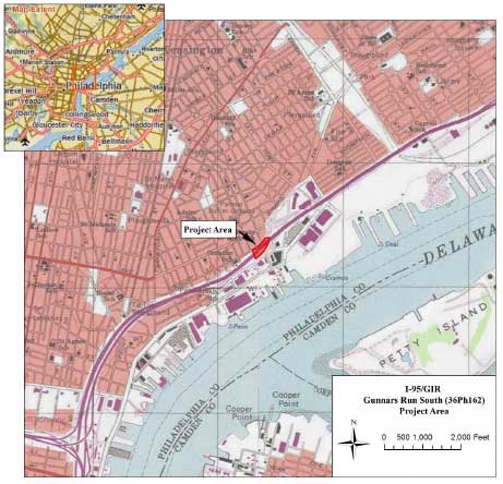
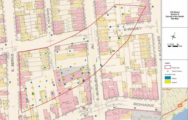
As defined during Phase IB/II testing, the Gunnar’s Run South Site (36Ph162) comprises approximately a 2.2-acre parcel of land bounded by Delaware Avenue to the south, Berks Street to the west, Wildey Street to the north, and the southern terminus of Aramingo Avenue to the east (Figure 1). Excavations were able to confirm that intact archaeological deposits and features are well-preserved beneath existing recent fill deposits across nearly the entire site. Identified archaeological resources include historic house and other building foundations, eighteenth through twentieth-century subsurface features (brick and wood-lined privies, refuse pits, etc.), and expansive sections of undisturbed historic ground surface (A horizon). Testing within the buried ground surface revealed a scatter of mixed historic artifacts, a concentration of gun flints and gun-flint fragments possibly associated with Revolutionary War–period military use of this vicinity, and extensive deposits of Native American artifacts tentatively dated to the Late Archaic through Late Woodland culture periods. Excavations also uncovered two partially intact prehistoric hearth features with associated lithic artifacts and wood charcoal.
The objectives of the Phase IB/II effort were to: 1) determine the presence/absence of any potentially significant prehistoric and/or historic archaeological deposits, building foundations, and other features; 2) assess the significance and integrity of archaeological deposits; and 3) provide recommendations regarding the potential eligibility of identified archaeological deposits for listing in the National Register of Historic Places.
Study Area Description and Existing Conditions
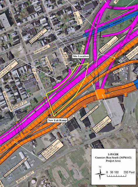
Improvements to I-95 in this vicinity will involve the removal and reconstruction of the existing highway viaduct, including the demolition of current roadway piers and other support structures, and the construction of a new exit ramp along the north side of Delaware Avenue (Figure 2). Additional ground disturbance could be associated with landscaping efforts, the installation of various utility conduits, and the creation of improved surface and/or subsurface drainage/storm water features.
At present, the Gunnar’s Run South Site consists of a combination of bare ground beneath the I-95 viaduct and grass-covered land to the south of the highway. With the exception of a line of small trees along the northern margins of Delaware Avenue, the entire site area is open and featureless. Prior to the construction of I-95, much of the site area consisted of undeveloped backyard and interior block space, with a segment of Susquehanna (formerly Wood) Street bisecting the eastern half of the site from northwest to southeast (this section of the street was vacated and demolished prior to the construction of the highway in the early 1970s). A short segment of Hewson Street (now demolished) also extended a short distance into the site from the north, but never extended all the way to Delaware Avenue. The topography within the site has been somewhat altered during landscaping related to I-95 and is now relatively flat, although ground surfaces do slope down slightly to the south and southeast, toward Delaware Avenue.
Historic Background
Early Owners to the Founding of Kensington
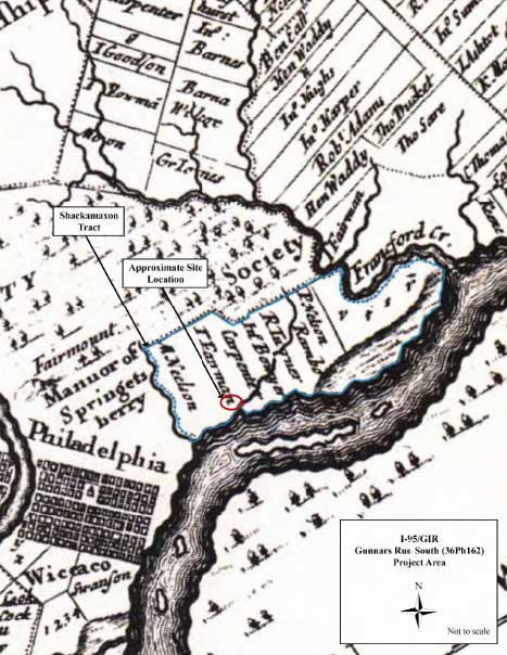
During the early historic period, the land encompassing the Gunnar’s Run South Site was part of a 1,600-acre parcel within the colony of New Sweden and patented to Peter Larsson Cock (Cox) on June 5, 1664. Later known as the Shackamaxon Tract, this estate was handed down to Peter’s son Lars (Lasse) Cock, as well as interrelated members of the Nilsson (Nelson) and Rambo families (Milano 2009a). Members of these families established a series of scattered farmsteads along the banks of the Delaware River between Cohocksink Creek and the modern neighborhood of Port Richmond, although the exact locations of their simple homes have never been firmly established.
In 1677, Lasse Cock sold his 300-acre portion of the Shackamaxon Tract to English Quaker Elizabeth Kinsey. The property, in turn, became part of the estate of Thomas Fairman following his marriage to Kinsey in 1680. During the early 1680s, Fairman’s home in Shackamaxon became a primary meeting place and sometime residence for William Penn and many of Penn’s key lieutenants—the group that organized and planned for the establishment of the city of Philadelphia. In 1702, Fairman built a large stone and brick manor house for himself and his family near the present-day intersection of Beach Street and Columbia Avenue, and immediately adjacent to what is now Penn Treaty Park (Milano 2009b). A few years later, a 191.5-acre parcel of Fairman’s estate was sold first to Thomas Redman (1716) and subsequently to Robert Worthington (Milano 2009a). This property—bounded by the Gunner’s Run stream channel to the north, the Delaware River to the east, Columbia Avenue to the south, and Frankford Avenue to the west—included the area of the Gunnar’s Run South Site (Figure 3).
The Founding of Kensington to the Revolutionary War
Intensive development and occupation of this vicinity did not occur until after Anthony Palmer purchased the Worthington property in 1730. Palmer had previously lived on a large estate known as Hope Farm, located to the north of Gunner’s Run near the present intersection of Beach and Cumberland Streets. Following his purchase of the former Fairman Mansion, Palmer began subdividing his property into smaller parcels for rent at reasonable rates, laid out a system of streets, and set about establishing a new settlement that he named Kensington, after a suburb of London (Milano 2011). As the village of Kensington began to grow, the earliest inhabitants were primarily comprised of recently arrived English-Welsh and German heritage. Many of these people were involved in the shipping, shipbuilding, and fishing industries, and quickly established new homes and commercial enterprises along the waterfront east of Queen (now Richmond) Street. By the time of his death in 1749, Palmer had rented out more than 50 properties and sold more than 25 others (Milano 2011; Remer 2002).
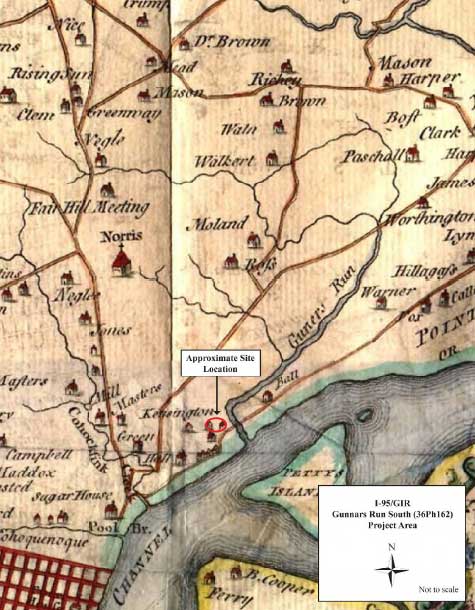
In the following decades, Kensington continued to grow, with newer residents occupying properties located to the west of Richmond Street. Though historic maps from this period are often wanting in terms of the depiction of detailed development, those examined for this management summary suggest that up until the time of the Revolution, the majority of occupation in Kensington continued to be clustered primarily along and in close proximity to Richmond Street. Some maps, such as the 1752 Scull and Heap plan, suggest that a number of homes may have been established within or in the immediate vicinity of the Gunnar’s Run South Site by this time (Figure 4).
The British Occupation
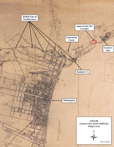
In 1777–1778, during the Revolutionary War, British forces occupied Philadelphia under the command of Sir William Howe. To protect the city against marauding American troops, the British established a string of 10 earthen fortifications along the then northern limits of Philadelphia. The easternmost of these fortifications, located within the present SugarHouse Casino property (opposite the intersection of Richmond Street and Frankford Avenue), was known as “Redoubt #1” and was manned by Loyalist troops belonging to British Lieutenant Colonel John Graves Simcoe’s Queen’s Rangers (Figure 5). During his time in Philadelphia, Colonel Simcoe kept a detailed diary of his unit’s actions, and several passages suggest that advanced picket outposts may have been established near the mouth of Gunner’s Run, possibly in the immediate vicinity of the Gunnar’s Run South Site, and that numerous skirmishes between forces occurred in this area:
The village of Kensington was several times attacked by the rebel patrolling parties; they could come by means of the woods very near to it undiscovered; there was a road [Richmond Street (interpretation added)] over a small creek [Gunner’s Run] to Point-no-Point; to defend this a house was made musket proof, and the bridge taken up [Richmond Street bridge over Gunner’s Run]; cavalry only approached to this post, for it lying, as has been mentioned, in an angle between the Delaware and the Frankfort road, infantry were liable to be cut off; on the left there was a knoll that overlooked the country [possibly West Hill, near the intersection of Belgrade and Susquehanna Streets]; this was the post of the piquet in the daytime, but corn fields high enough to conceal the approach of an enemy reached to its basis; sentinels from hence inclined to the left and joined those of Colonel Twistleton’s… light infantry of the guards, so that this hill projected forward, and on that account was ordered by Sir William Erskine not to be defended if attacked in force, and it was withdrawn at night. It was usual, if the enemy approached, to quit this post till such time as the corps could get under arms, and the light infantry of the guards were informed of it; when, marching up the road, the enemy fearing to be shut up within the creek that has been mentioned, abandoned their ground and generally suffered in their retreat to the woods. At night the corps was drawn back to the houses nearer Philadelphia, and guards were placed behind breastworks, made by heaping up the fences in such points as commanded the avenues to the village; (which was laid out and enclosed in right angles;) these were themselves overlooked by others that constituted the alarm post of the different companies. Fires also were made in particular places before the piquet, to discover whatsoever should approach. Before day the whole corps was under arms, and remained so till the piquets returned to their day post, which they resumed, taking every precaution against ambuscades; the light infantry of the guards advanced their piquets at the same time, and Colonel Twistleton was an admirable pattern for attention and spirit, to all who served with him. He was constantly with the piquets, which generally found out the enemy’s patroles, and interchanged shot with them: his horse was one morning wounded by a rifle shot. The mounted men of the Queen’s Rangers were found very serviceable on these occasions. The woods in front were every day diminishing, being cut down for the uses of the army, and the enemy kept at a greater distance [Simcoe 1844].
Simcoe’s journal clearly indicates that the Queen’s Rangers frequently moved through the site vicinity during the conduct of patrols to Frankfort, as well as in the process of foraging for supplies in the surrounding countryside. Confirmation of this military activity in the site vicinity was also presented in testimony given before the Pennsylvania Supreme Court in 1832. In the case Ball v. Slacker (concerning property rights near the mouth of Gunner’s Run), a man named John Rice, himself a long-term resident of Kensington, related the following account:
There was a flood-gate below where the bridge now is [Richmond Street bridge over Gunner’s Run], and two sluices; before 1774, I used to cross and go up the place where Dyott’s is… when the British were in Philadelphia, the guard used to lay there. The old house, Baker’s, was on the lot at that time. At that it was banked up with a temporary bank of logs… When the British left Philadelphia, they opened the dam of the old creek [Wharton 1884: 519].
This account supports Simcoe’s journal in several ways—by alluding to the British destruction of structures on Gunner’s Run, by indicating that a picket or outpost of some sort was established near the creek, and by identifying a private residence evidently fortified for military use. That house, Baker’s, was likely located across Gunner’s Run from the Dyottville Glassworks site. Baker’s property, as detailed in the court case, extended from Richmond Street to the river on the west side of Gunner’s Run. This would have placed the fortified house on the opposite side of Richmond Street from the Gunnar’s Run South Site.
Nineteenth-Century Development
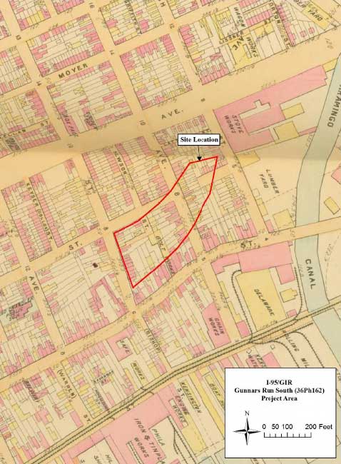
After the Revolution, the village of Kensington continued to expand and become more populous, especially as the region became progressively more industrialized. Throughout the late eighteenth and nineteenth centuries, the site area incorporated multiple small residential properties, and consisted largely of undeveloped open yard space associated with homes fronting on the north side of Richmond Street, the east side of Berks (formerly Vienna) Street, and both sides of Susquehanna (formerly Otis) Street. Beginning in 1842, one of the Richmond Street properties that extended into the site area was the home of the Kensington Hose Company, one of the city’s many all-volunteer fire departments. Formed by a group of roughneck fishermen from the surrounding neighborhood, this company was given the nickname “Shad Hose” and remained in the same location until the early 1870s (Scharf and Westcott 1884; Cramp 1909). For the most part, the only industrial development within the site area during the nineteenth century consisted of the construction of a nuts and bolts/hardware warehouse complex on portions of the former Kensington Hose Company lot (Figure 6).
Twentieth-Century Development
Throughout the twentieth century, the site area appears to have been little changed and remained primarily open, undeveloped yard space. In the late 1960s, the state of Pennsylvania purchased and demolished properties within this block in preparation for the construction of I-95. The site area was ultimately filled in and landscaped in association with highway construction but, based on the results of archaeological testing, these activities had little impact on the continued preservation of subsurface cultural deposits.
Field Methodology
Archaeological testing within the study area was completed using a combination of machine excavated trench tests and 5-x-5-foot excavation units (EUs). A single exploratory trench was completed within the site during Phase IB testing and ran parallel to the highway beginning at a point approximately 200 feet east of Berks Street. This trench was located within the site via georeferencing satellite images of the project site with the 1875 Hopkins and 1878 Hexamer maps of the city. Trench excavation was specifically intended to establish stratigraphic sequences for the site, as well as to identify any potential intact soil horizons that could contain evidence of Native American occupation or historic midden deposits.
Excavation units were placed throughout the site following the machine-assisted stripping of overlying fill deposits. During Phase IB work, these were placed in a regular grid pattern, with units spaced at intervals of 50 feet. For subsequent Phase II testing, the unit interval was first closed to 25 feet; a series of judgmentally placed units were subsequently excavated in order to more closely examine potentially significant features and/or artifact deposits.
During Phase IB/II testing, excavated soils from intact soil horizons, as well as from identified features, were screened through ¼-inch hardware cloth. All recovered artifacts were retained in labeled plastic bags pending laboratory analysis and cataloging. Historic fill deposit soils were screened if it was determined that artifacts recovered would contribute to the overall interpretation of site stratigraphy or a specific fill deposit. Trench, excavation unit, artifact, and feature provenience within the study area was established using total station survey equipment in concert with submeter-accurate GPS data collectors. All excavation data was fully documented through the use of standardized paper field forms, hand-drawn plan and profile maps, and high resolution digital photography.
Field Results
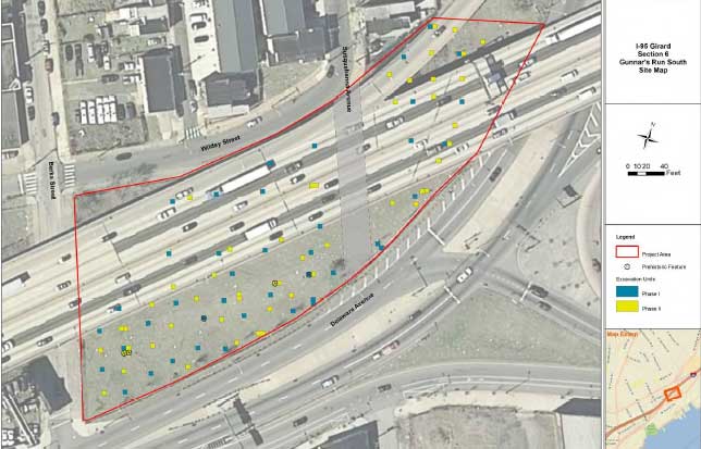
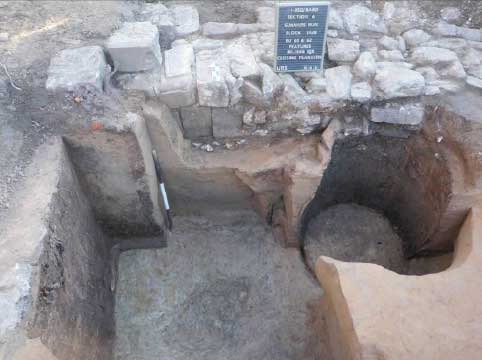
Completion of Phase IB/II investigations at the Gunnar’s Run South Site involved the excavation of 89 5-x-5-foot excavation units (Figure 7). Investigations at the site produced an assemblage comprising a total of approximately 10,000 artifacts (based on field counts), including items of both prehistoric and historic manufacture. Historic materials constitute the single largest class of artifacts recovered from the total assemblage, consisting of a variety of domestic, architectural, and military-related items potentially dating from the eighteenth through nineteenth centuries. Prehistoric cultural materials are represented primarily by flaked stone tools, debitage, and firecracked rock (n=1,491), along with a small handful of pottery fragments. Diagnostic artifacts present in the assemblage range from the Late Archaic through the Late Woodland culture periods.
Site Stratigraphy
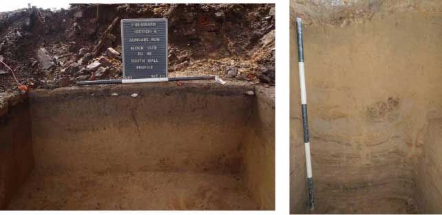
In terms of stratigraphy, unit excavation revealed and confirmed the study area to possess a relatively varying surface profile consisting of aeolian and alluvial processes. In most cases, profiles tended to represent an upper layer of modern fill (Stratum I) associated with I-95 construction-related activities, overlying intact plowzone (Stratum II; Ap horizon), E horizon
(Stratum III), and B/Bt horizon (Stratum IV) soils. (Note: Geomorphologist Daniel P. Wagner documented soils within the study area; a written report of his findings is pending.) Stratum I fill consisted of varying construction-related fill. Testing revealed that this upper fill matrix progressively thickens toward the north and varies between 1.5 feet in depth at the southern end of the study area (near Berks Street.) to approximately 5 feet in depth in the northernmost sections (north of the Susquehanna Avenue). This pattern of thickening of the upper fill was an intentional element to artificially raise the internal ground surface to retain a continuous grade for the highway and adjacent streets.
Beneath the modern fill, testing encountered intact soils throughout the entire study area. In this area, intact historic ground surfaces were perforated by a series of stone, brick, and concrete
foundations associated with a variety of domestic household structures dating to the late eighteenth through twentieth centuries. Disturbances in these instances were confined to relatively limited areas within and surrounding the exposed foundation walls. Intact soils within the study area tended to vary from floodplain to terrace-like deposits. In most cases, construction-related activities severely truncated excavation units along the southern boundaries of the project area.
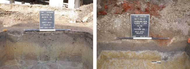
In portions of the study area containing wetland and floodplain deposits (Figure 8), intact to partially truncated Ap/plowzone soils varied between 0.5 and 1.5 feet in thickness and consisted of 10YR 4/4 dark yellowish brown silt loam. Underlying E-horizon soils were present in the eastern portions of the site, but not in the westernmost parts. The soil matrix consisted of a layer that varied between 0.1 and 0.4 feet in overall thickness, and consisted of 10YR7/1 light gray sandy silt. Underlying strata consisted of B-horizon soils (7.5YR5/6 strong brown sandy clay) exhibiting highly oxidized characteristics.
The central and northern portions of the site contained aeolian soil deposits, forming an upland landform that exhibited long-term deposition and pedological stability (Figure 9). The Ap horizon (10YR4/4 dark yellowish brown silt loam) continued as a partially intact or truncated matrix that varied in thickness from 0.2 to 1 foot. The underlying stratum uniformly appears as an E horizon. Stratum III consists of a 2.5Y5/6 light olive brown sandy silt approximately 0.3 feet thick. Bt-horizon soils throughout the site consisted of 7.5YR 4/6 strong brown sandy clay. In central and northern portions of the project area, deeper excavation within a selection of test units identified preserved loess sediments, exhibiting evidence of remnant late Pleistocene landform development at 2 to 2.5 feet beneath the top of the Ap/plowzone horizon. Consultations with Daniel P. Wagner determined that the preserved loess sediments display low probability for prehistoric occupations. With continued variance, stratigraphy in the eastern site areas showed signs of modification by the meandering Gunner’s Run stream channel at approximately 3 to 3.5 feet beneath the top of the Ap/plowzone horizon.
Prehistoric Site Component
Initial test unit excavations revealed the presence of an expansive, low-to-moderate-density prehistoric artifact scatter across the eastern portions of the study area, and extending outward an indeterminate distance to the east and south. In terms of their vertical distribution, the majority of artifacts (n=1,002, or 67.2%) derived from Ap-horizon soil deposits, with a somewhat higher proportion of items tending to be recovered in close proximity to the Ap/E interface. Approximately 166 prehistoric artifacts (11.2%) were recovered from undisturbed contexts within the underlying strata, including 13 artifacts removed within the lower Bt/B-horizon soil matrix. No artifacts were recovered from loess deposits. Artifacts identified in disturbed contexts, such as historic feature fill and modern fill, comprise 9% of the artifact distribution.
Native American artifacts are represented by pieces of lithic manufacturing debitage, a number of both formalized (diagnostic bifaces) and expedient tool forms (utilized flakes, hammerstones, etc.), and quantities of fire-cracked rock (FCR) (Table 1). Identified lithic raw materials include quartz, argillite, chert, quartzite, jasper, and sandstone (the latter represented predominantly as FCR). FCR (n=743; 49.8%) and lithic debitage (n=696; 46.7%) constitute the largest artifact categories. Lithic debitage consists of items representing the full range of stone tool manufacture, from the initial testing of unmodified raw material to late-stage reduction. Of the identified debitage, 39.8% (n=212) of the flakes recovered were manufactured of quartzite. Jasper (n=134; 19.3%) and quartz (n=141; 20.3%) flakes evenly comprise the bulk of the remaining debitage.
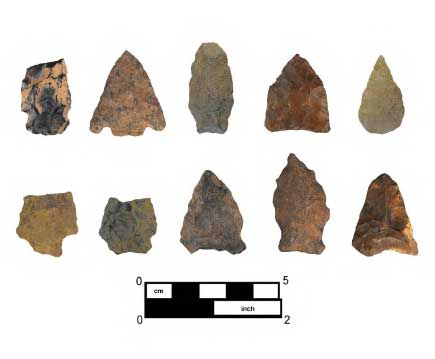
Flaked stone tools from the site are represented by both bifacially and unifacially worked pieces (Figure 10). A total of 22 bifacial tools or tool fragments were recovered, including 10
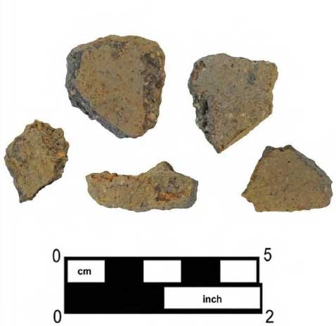
temporally diagnostic projectile points and reworked points. The diagnostic points include one basal-notched point (quartz), five side-notched and contracting stem points (chert and quartzite), one jasper pentagonal-shaped triangular point, and one jasper triangular point. The unifacial tools (n=10) recovered consist of six utilized flakes, three scrapers, and a retouched flake. Cores and cobble/groundstone tools are only minimally represented. Other notable artifacts recovered include five crushed rock-tempered sherds of undecorated prehistoric pottery (Figure 11).
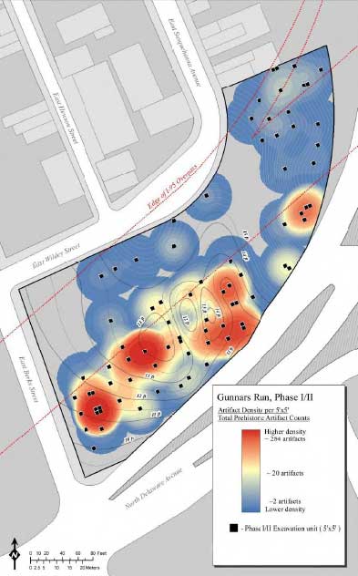
Testing within the study area identified that the highest density of prehistoric artifact deposits was limited to the open space in the easternmost portions of the site, between the extant I-95 roadway and Delaware Avenue (Figure 12). Clustering of raw materials did occur across these higher density areas, and gaps between clusters can be accounted for by disturbances associated with public utility excavations within the former East Susquehanna Avenue alignment, as well as by significant truncation of soils via construction-related activities in the southeastern portions of the site. Clusters or loci were comprised of similar assortments of raw materials and the presence of FCR. No correlated distribution of formal and expedient tool forms, pottery, and/or other potentially diagnostic artifact types could be distinguished, except for their occurrence within the easternmost portions of the site.
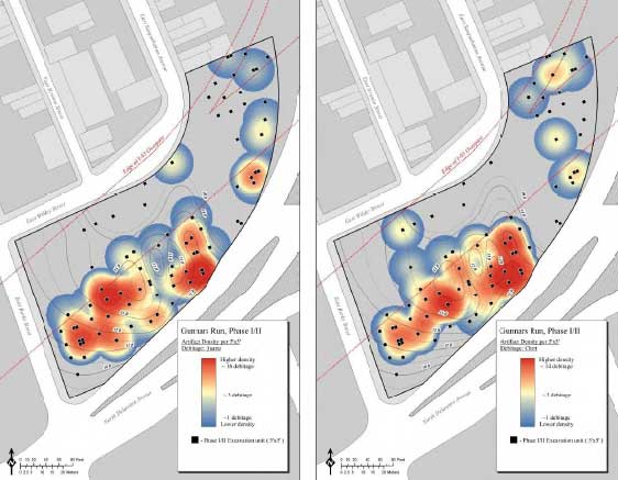
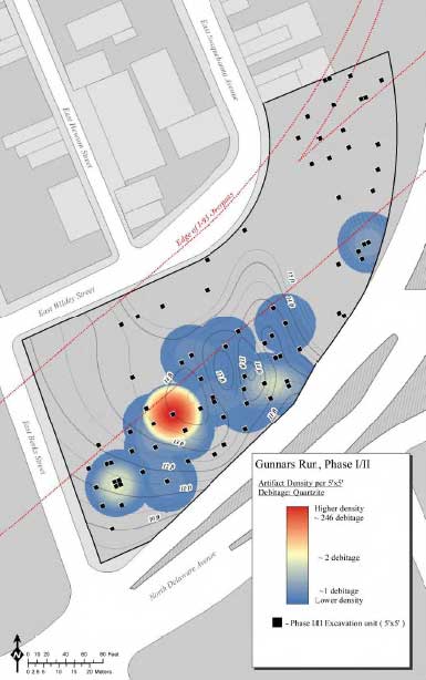
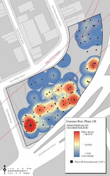
Quartz and chert appear to correlate together across the site (Figure 13). The occurrence of a specific quartzite cluster occurs at the edge of the terrace and can be identified as a knapping cluster, based on the stages of artifact reduction seen within the assemblage (Figure 14). Argillite and jasper follow the same distribution as seen for overall debitage. Densities of FCR can be seen across the easternmost portions of the site (Figure 15). A particular cluster occurs in the southern end of the site and can be accounted for through the identification of two partially intact prehistoric hearth features.
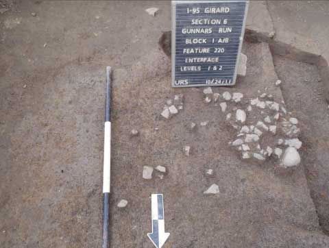
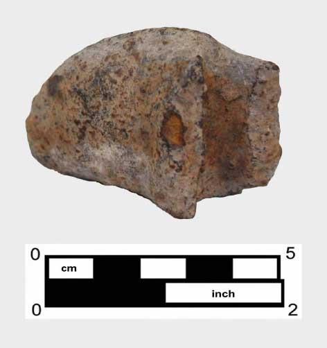
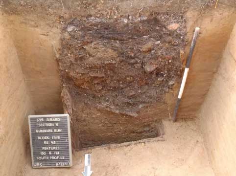
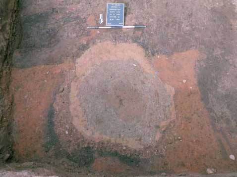
Two intact prehistoric subsurface hearth features were identified at the site, along with an additional three possible truncated prehistoric features. The three possible prehistoric features were identified in E-horizon soils deposits, and were marked by slight concentrations of in situ FCR and associated staining. All three appeared to have been substantially truncated via historic-era plowing. The two intact prehistoric hearth features were identified at the interface of the Ap and A/B horizons; both appear to be mostly intact, with minimal truncation. The first of these (Feature 220) was identified at the interface in EUs 79 and 87. It consisted of FCR grouped with small amounts of associated charcoal (approximately 2.2 x 1.5 feet). Feature 220 extended to a depth of 0.4 feet into E-horizon soils (Figure 16). Artifacts from the feature consisted of FCR (n=138) and one-half of a thermally altered steatite bannerstone (Figures 17 and 18). All associated feature soil was collected and removed to the URS laboratory for more thorough processing and recovery. Charcoal samples from this feature were submitted for C-14 dating, and returned a date of 2200 to 2030 cal B.C. (Cal BP 4150 to 3980) (p = 0.950) (Calibrated at 2σ with CALIB 6.0 [INTCAL09]).
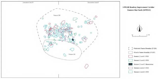
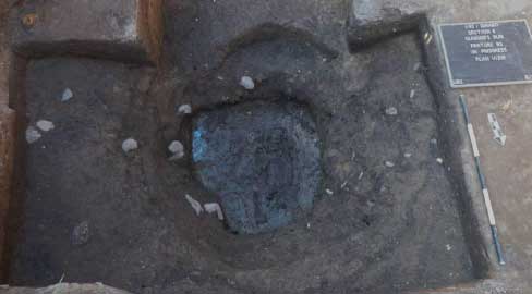
The second feature (Feature 255) was identified in the southeastern corner of EU 87, in close proximity to Feature 220 (approximately 3.9 feet southeast), and contained large concentrations of FCR at the surface (n=28). It is situated within the A/B horizon, 0.5 feet below Feature 220. Small amounts of charcoal were identified throughout the exposed feature matrix; however, the majority of this feature extended outside the EU and has not yet been excavated. Feature 255 was sealed and closed to allow for excavation during data recovery.
Historic Site Component
Historic-period artifacts were also recovered over the entire study area. For the purposes of this management summary, these items can be lumped into two broad categories based on their likely historical association: Revolutionary War (British) military outpost and household related. All artifacts were identified exclusively from plowzone soils, or in association with historic features that continued into underlying soil horizons (Figure 19).
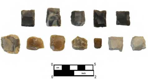
Military artifacts—possibly from British troops during the Revolutionary War occupation of Philadelphia—are largely represented by complete gunflints of English, French, and local varieties of raw material, as well as apparent manufacturing debris. Approximately 50 complete gunflints were recovered from the site, along with some 200 gunflint fragments representing various stages of manufacture. The fragmentary material consists of partial gunflints, two or more apparent cores of raw material, and flakes struck from those cores. This gunflint material was found throughout the site; however, the vast majority was concentrated in the far north limits of the site (Figure 20).
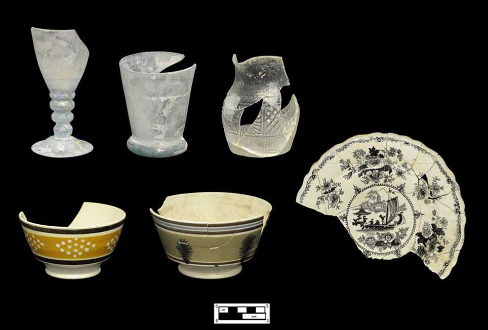
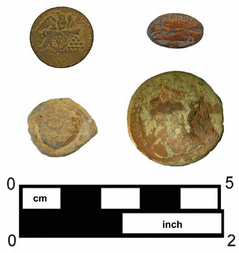
Domestic household-related artifacts appeared continuously across the site. Historic artifacts are largely represented in fragmentary ceramic and glass domestic refuse, as well as smaller quantities of architectural debris, such as window glass and nails. Potentially diagnostic ceramic sherds date to the eighteenth through twentieth centuries, and are represented by an assortment of redwares (unglazed, Staffordshire, black and brown glazed, trailed-slip decorated) and whitewares (undecorated, blue and black-transfer, lusterware), quantities of pearlware (undecorated, polychrome), porcelain (hand-painted), creamware (undecorated), delft, and stoneware (scratch-blue). Other diagnostic items include eighteenth- through twentieth-century personal items, such as beads (glass), buttons, pipe stems/bowls, and coins (Figure 21).
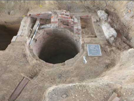
A total of 213 historic features were identified, most of which clearly dated to the late nineteenth or early twentieth centuries, and were associated with domestic household lots and structures. The domestic household features were represented by a series of stone building foundations (n=27), postholes and molds (n=59), brick privies (n=2), box (n=7) and barrel refuse pits (n=7), other pit features, two dog burials, and drainage ditches or utility trenches (Figures 22–24). Artifacts from these features are dominated by domestic glass, ceramics, architectural artifacts, and personal items. All household-related features within the study area occurred in areas where historic maps identify structures to have once existed.
Two features (93 and 225) could provide evidence of early occupation of this vicinity, and perhaps of a possible military occupation, as well. Feature 93 was identified as a eighteenth- or nineteenth-century pit or barrel feature (8.8 x 7.4 feet) located in the area of densest gunflint deposition (Figure 25). After excavating the uppermost strata (4 feet), it was discovered that the pit extended well below the limits of excavation and would require shoring to complete. The feature was closed and sealed to allow for further investigations at a later date (Figure 26). Over 1,000 artifacts were recovered, including pearlware, creamware, redware, personal items, architectural material, and English/French flint fragments. Feature 225 (2.3 x 1.1 feet) was
located in EU 79/87 and was identified as a pit feature. Located at the southern end of the site, Feature 255 cut into Feature 220, a prehistoric hearth feature. Artifacts from this feature included fragments of creamware and a King George II half-penny.
Conclusions and Recommendations
Based on the results of Phase IB/II testing, the Gunnar’s Run South Site (36Ph162) has been determined to represent a mixed prehistoric and historic-period archaeological resource, and it is
URS’s opinion that the artifact deposits and features contained within it are eligible for listing in the National Register of Historic Places. It is believed that planned construction activities related to I-95—which are to include the creation of a new exit ramp, the installation of new utility conduit and drainage features, and likely landscaping activities—will have a serious negative impact on the continued integrity and preservation of these resources.
Native American component artifacts are spread throughout the entire site area, but are significantly more prevalent in the open, grassy area between the elevated I-95 roadway and Delaware Avenue, and cover an area of approximately 0.83 acres/36,048 square feet. Within this space, artifacts tend to be concentrated in a series of spatially distinct activity areas likely associated with a series of short-term occupations tentatively dated to the Late Archaic through Late Woodland periods. The first of these activity areas was identified at the far northern limits of the site; a second locus was found in the central portions of the test area; and two more were located in the southernmost area. Overall, the highest density of artifacts and of FCR was recovered from the central section of the site, in an area corresponding to the position of a slightly elevated knoll landform overlooking the confluence of Gunnar’s Run and the Delaware River.
Artifacts within the site were recovered primarily from an intact buried historic plowzone (Ap horizon), with a smaller amount found in the underlying E horizon. In the far southern sections, Ap soils are underlain by an apparent undisturbed or partially truncated A horizon, and so far two intact prehistoric hearth features have been delineated in the intact B-horizon soils beneath this remnant ground surface. One of these features (Feature 220) is a largely intact hearth that has been carbon dated to the Late Archaic culture period (cal. 2200–2030 B.C.). Additional partially truncated features are likely to be contained in other portions of the site. While temporally diagnostic tools (points) have been recovered throughout the highest density section of the site, so far these artifacts have not exhibited sufficiently distinctive morphologies to allow specific activity areas to be assigned to clear-cut culture periods or date ranges. Further C-14 samples derived from additional site features could help to significantly clear up site dating and occupational sequence issues.
Interestingly, this site appears to be quite different in some ways than other Native American sites previously identified along the I-95/GIR corridor. This is the only site so far found that contained a basally notched point reminiscent of the Erb-Eshback variety. The other distinction involves the lithic materials present. Whereas other sites found along this section of I-95 have tended to contain lithic assemblages dominated by argillite and jasper, at this site, quartzite and quartz are the dominant lithic materials. These distinctions in lithic representation could indicate a difference in the age-range of this occupation.
The historic component within the site consists of a concentration and scatter of possible Revolutionary War–era gunflints and a generally low-density domestic midden scatter within the buried plowzone/ground surface, and artifact deposits contained in an intact or partially disturbed privy and other features. The gunflint concentration so far represents a unique artifact component for the I-95/GIR project, and is believed to be possibly associated with the activities of British and Loyalist troops assigned to the defense of the city during its occupation, in 1777–1778. Historic accounts confirm that British military units were active in this vicinity, and did establish picket posts at or near Gunner’s Run to guard against American incursions from north of the city. The presence of complete and partial flints, cores of raw material, and probable manufacturing debris suggests that gunflints were being both created and reworked in this location, and most notably in the far northern limits of the site, nearest to the former Gunner’s Run stream channel.
The domestic midden deposits appear to be fairly uniform across the site, and are generally represented by highly fragmented domestic artifacts dating to the eighteenth through twentieth centuries. Despite efforts to identify areas containing a preponderance of earlier artifacts—and therefore possibly associated with the earliest occupants of this location—no unambiguous patterns of differential distribution could be clearly delineated. As a result, historic artifacts contained in the buried ground surface are likely to be less useful in understanding the occupational sequence for any given house lot, and would be difficult to attribute to any specific household.
Historic features within the site, on the other hand, have generated both a larger volume and higher quality of data than the midden artifacts. Artifact bearing strata within these features have been tentatively dated to the eighteenth and nineteenth centuries and do have the potential to generate significant information about individual properties and specific households or occupations. Phase IB/II testing suggests that there are likely to be a considerable number of similar, currently unexcavated features spread throughout the site that could be investigated through more intensive archaeological excavation.
Based on the findings presented in this management summary, URS believes that both the prehistoric Native American and historic components of the Gunnar’s Run South Site are eligible for listing in the National Register of Historic Places. Given that these resources are likely to be severely impacted during proposed highway construction activities, it is recommended that additional Phase III data-recovery investigations be conducted within the site in order to mitigate the effects of those impacts.
References
Anonymous
c. 1777 Map of Philadelphia and vicinity during the British occupation. Historical Society of Pennsylvania Map Collection, Call number: Of610ca.1777b.
ArcGIS Online
2011 Electronic document, http://services.arcgisonline.com/arcgis/services, accessed August 2011.
Baist, G. William
1895 Baist’s Property Atlas of the City of Philadelphia, Pennsylvania. G. Wm. Baist, Philadelphia.
Cramp, Charles H.
1909 Old Kensington District and Its Memories: Profit and Adventure in Privateering – Perils and Excitement on the Mississippi – Stimulus in Coal Trade and Shipbuilding – Proud Record in Marine Architecture – “Fishtown” and Its Heyday. Public Ledger Magazine, March 9, Philadelphia, PA.
Holme, Thomas
1681 A map of the improved part of the Province of Pennsilvania in America: begun by Wil. Penn, Proprietary & Governour thereof. London.
Milano, Kenneth W.
2009a Shackamaxon Timeline. Electronic document, http://kennethwmilano.com/page/Encyclopaedia/Shackamaxon/ShackamaxonTimeline/tabid/209/Default.aspx, accessed March 2012.
2009b The History of Penn Treaty Park. The History Press, Charleston, SC.
2010 Hidden History of Kensington & Fishtown. The History Press, Charleston, SC.
2011 Palmer Cemetery and the Historic Burial Grounds of Kensington and Fishtown. The History Press, Charleston, SC.
Remer, Richard
2002 Old Kensington. Pennsylvania Legacies, Volume 2, Number 2. Historical Society of Philadelphia.
Scharf, J. Thomas, and Thompson Westcott
1884 History of Philadelphia, 1609–1884, Vol. 3. L. H. Everts and Company, Philadelphia.
Scull, Nicholas and George Heap
1753 A Map of Philadelphia and Parts Adjacent. London.
Simcoe, John Graves
1844 Simcoe’s Military Journal. A History of the Operations of a Partisan Corps, called the Queen’s Rangers, commanded by Lieut. Col. J. G. Simcoe, During the War of the American Revolution; illustrated by Ten Engraved Plans of Action, &c. Now First Published, with a Memoir of the Author and other additions. New York: Bartlett & Welford.
Wagner, Daniel P.
2011 Personal communication to Senior Archaeologist Douglas Mooney regarding geomorphological interpretations of soils examined within the Gunnar’s Run South Site; Aug. 11.
Wharton, Thomas I.
1884 Reports of Cases Adjudged in the Supreme Court of Pennsylvania, in the Eastern District. Philadelphia, T. & J.W. Johnson & Co.