Introduction
The following management summary documents the preliminary findings of Phase IB/II archaeological excavations performed as part of the I-95/GIR Improvement Corridor Project for the Pennsylvania Department of Transportation (PennDOT), Engineering District 6-0. These investigations were performed by the URS Corporation (URS) within a portion of the GR-1 section of the larger project area, and specifically within a mixed Native American/Historic Period locus that has been designated the Hope Farm-Richmond Hall Site (site number pending). All archaeological testing within this site was conducted in accordance with Section 106 of the National Historic Preservation Act of 1966, as amended; 36 CFR Part 800, particularly sections 800.4, and 800.5; as well as the Pennsylvania Historical and Museum Commission (PHMC), Bureau of Historic Preservation’s (BHP) Guidelines for Archaeological Investigations (1991). Work was also in accordance with the PennDOT’s Directive 430-92-29 dated March 18, 1992.
The objectives of the Phase IB/II effort were to: 1) determine the presence/absence of any potentially significant prehistoric and/or historic archaeological deposits, building foundations, and other features; 2) establish the horizontal and vertical/stratigraphic extent of identified deposits and features; 3) assess the significance and integrity of archaeological deposits; and 4) provide recommendations regarding the eligibility of identified archaeological deposits for listing in the National Register of Historic Places (NR).
Study Area Description and Existing Conditions
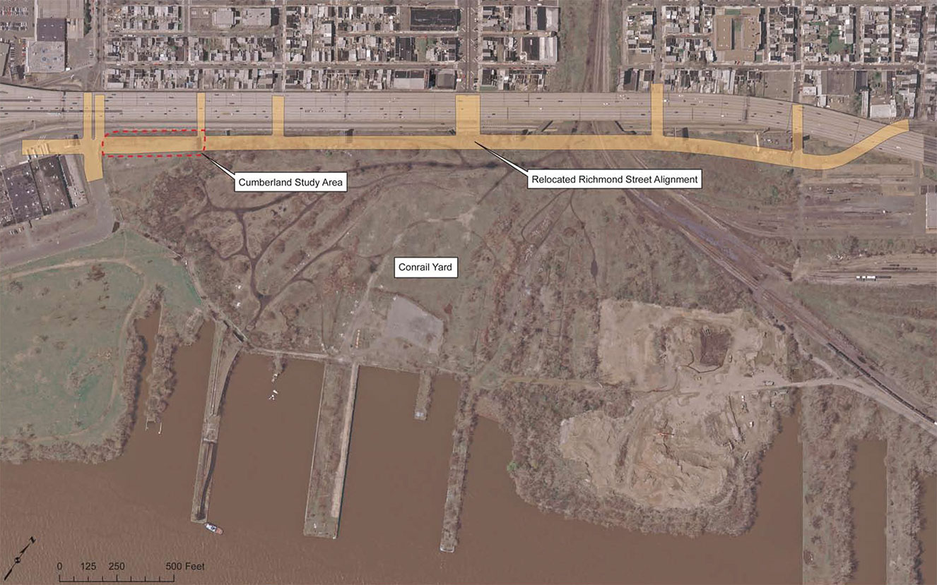
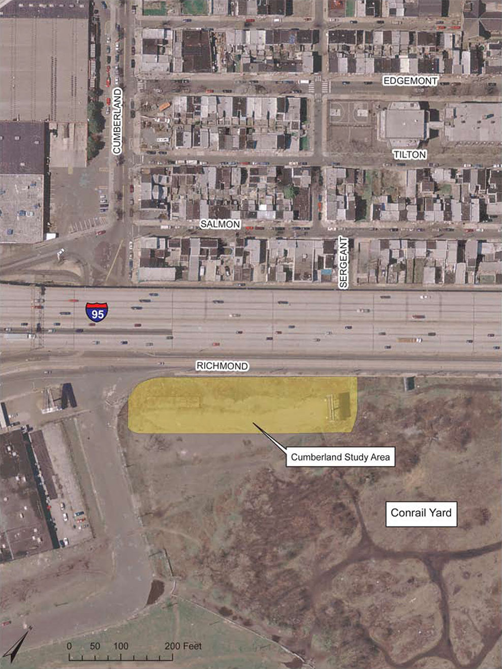
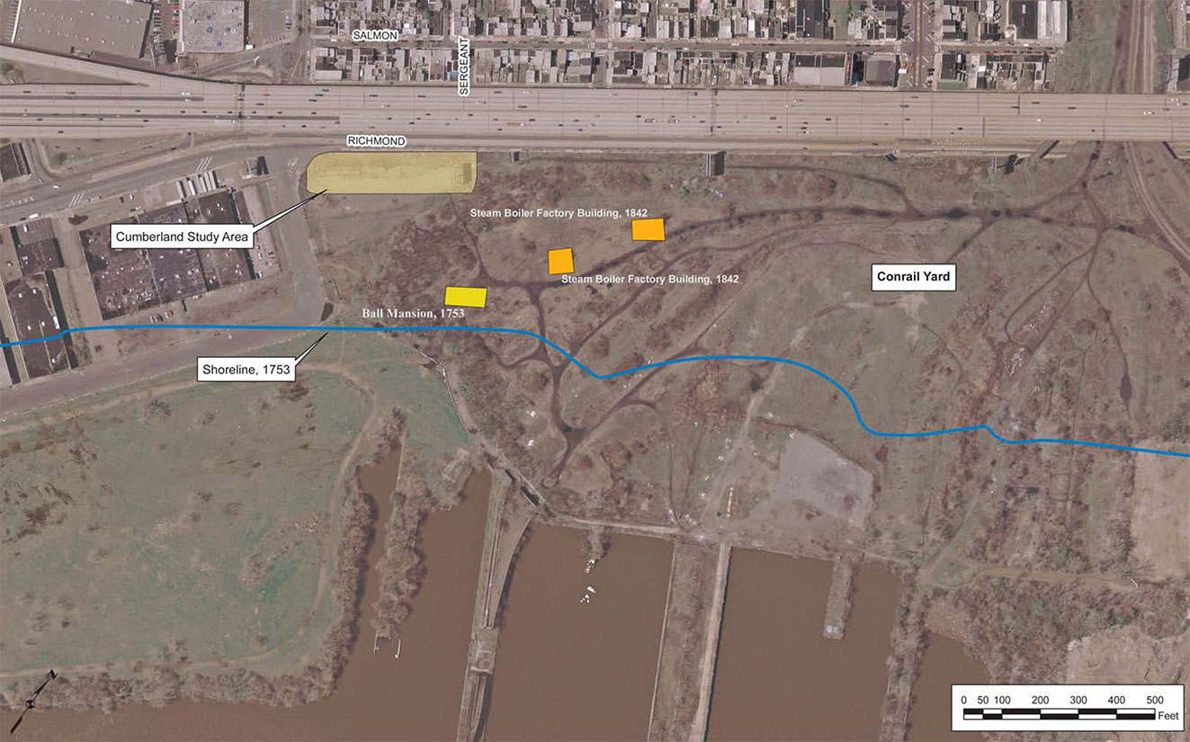
Improvements to I-95 in this portion of Section GR-1 involve shifting the alignment of Richmond Street to the east of its present location, to a parallel alignment located within the far western margins of the adjacent Port Richmond/Conrail Rail Yard (Figure 1). This relocated section of Richmond Street extends roughly from Cumberland Street in the south to Ann Street in the north – a distance of approximately 3,600 ft. / 1,100 meters. However, the study area documented in this management summary includes only a portion of this larger area, and encompasses a Right-of-Way (ROW) within the Rail Yard measuring approximately 100 feet wide by 440 feet in length (ca. 1.0 acres), and extending from Cumberland Street, in the south, to Sergeant Street in the north (Figure 2). Although ROW to the north of Sergeant Street will eventually need to be tested and evaluated for potential cultural resources, the present study area represents the largest part of the relocated Richmond Street alignment that could reasonably be accessed using traditional archaeological methods. Existing soil boring data indicates that, in areas to the north of Sergeant Street, soil horizons of potential archaeological interest are buried some 9 to 12 feet or more beneath the existing rail yard surface. Given the prohibitive restrictions involved in testing these areas, archaeological investigations to the north of Sergeant Street will be completed later, in conjunction with the active construction phase for the new Richmond Street alignment.
Within the current study area, site conditions prior to the start of archaeological investigations were characterized by an asphalt (over Belgian Block) paved area across the eastern two-thirds of the ROW, and extending 450 feet north from Cumberland Street. The only above ground structures within this space consisted of an approximately 4.0-foot high concrete railroad freight platform (ca. 1950) located at the southwest corner of the study area. Sections of the study area were densely overgrown with trees and weeds, most notably around the freight platform and along the western margins of extant Richmond Street not covered by asphalt. North of the paved area, the dense overgrown conditions extended across the entire project site alignment continuing the entire length of the Conrail ROW to Cambria Street. As revealed by previous soil boring tests through this area (2008), the entire study area was known to contain an upper mantle of railroad related fill matrix, some 2 to 6 feet in depth, capping extensive deposits of apparently undisturbed soils below.
Historic Background
Throughout the historic period lands contained within the present study area have escaped intensive development, and consequently have never experienced the kinds of ground disturbances that characterize most urban environments, and neighboring sections of Philadelphia. Situated atop a low, Late Pleistocene-age terrace adjacent to the Delaware River, this area from the mid 17th through mid 19th centuries consisted of open meadow or agricultural grounds contained within the expansive rural estates of Swedish and English colonists. In the late 19th century the project area became part of the Reading Railroad’s massive Port Richmond Coal Yard along the Delaware waterfront, and was buried beneath several feet of fill and active rail sidings. While the train track has now been removed from this property, the project area remains devoid of development and conditions within the site have not changed appreciatively in the past 100 or more years.
During the 17th century, lands along the west bank of the Delaware River were first settled by Europeans and became incorporated into the colony of New Sweden. By the 1650s lands encompassing the present study area had been broken out into distinct land grants, were cleared, and were being actively farmed by members of the Cock, Rambo, Nelson, and other inter-related families. These individuals regularly interacted with groups of the local Lenni Lenape tribe, who continued to inhabit the vicinity. Taking a cue from Native peoples, early Swedish settlers called the area they lived in “Shackamaxon”, after the name of a prominent nearby Lenape settlement.
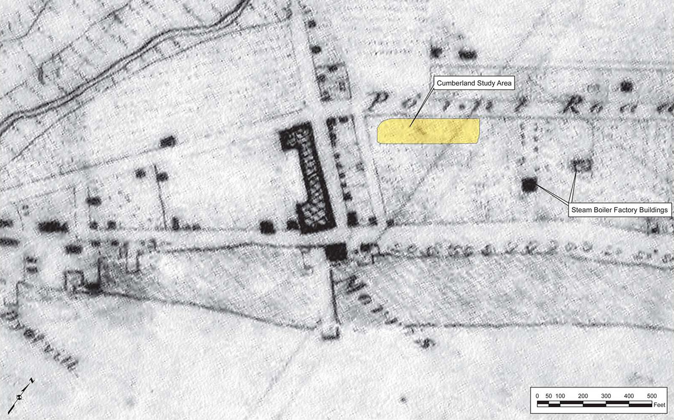
![Figure 3. 1753 survey of the Ball Estate lands, showing the Cumberland Street study area and its relationship to the Ball Mansion [Richmond Hall] (Source: Grover 1753)](https://diggingi95.com/wp-content/uploads/2015/12/Draft-Man-fig-03.jpg)
Palmer resided at Hope Farm for some 25 years before selling his property to one of his countrymen and moving a short distance to the south, to Thomas Fairman’s former estate in what is now the neighborhood of Kensington. Sometime around 1729, Hope Farm was purchased by William Ball, a distant relative of George Washington. Ball either enlarged Palmer’s existing manor house or built a new one entirely, and changed the name of the estate to “Richmond Hall” (the surrounding modern neighborhood – Port Richmond – derived its name from Ball’s estate). Ball remained in residence here until his death, in 1740, when the estate passed into the hands of his son, William Ball, Jr. (Figure 3). After the son’s death, in 1810, the Richmond Hall property remained in family hands until 1821, after which the legal disposition of the land seems to have been tied up in ongoing court battles for some time (Milano 2010).
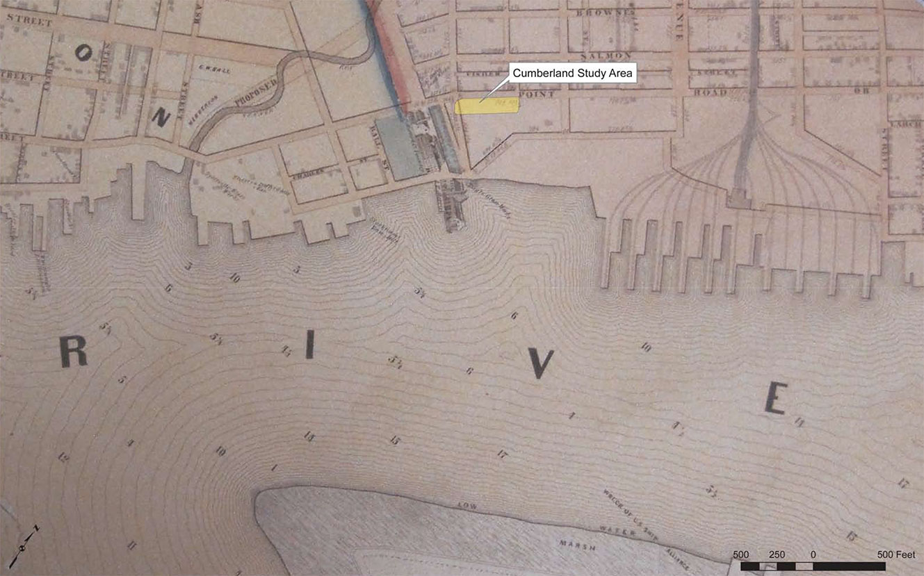
In 1837, at least some portion of the former Ball estate was sold to the Reading Railroad for the construction of their massive Port Richmond Coal Terminal complex, though it is not clear if this initial purchase extended south to include the present study area (Fisher 1962). Historic maps from the 1840s show a handful of non-railroad related buildings in the general vicinity of the study area, including “McQuaid’s Tavern”, along the north side of Cumberland Street, and a Steam Boiler Factory to the north of the former Richmond Hall house location. By and large, however, maps from the mid 19th century period seem to indicate that the land encompassing the present study area remained undeveloped, if not completely vacant (Figures 4-6).
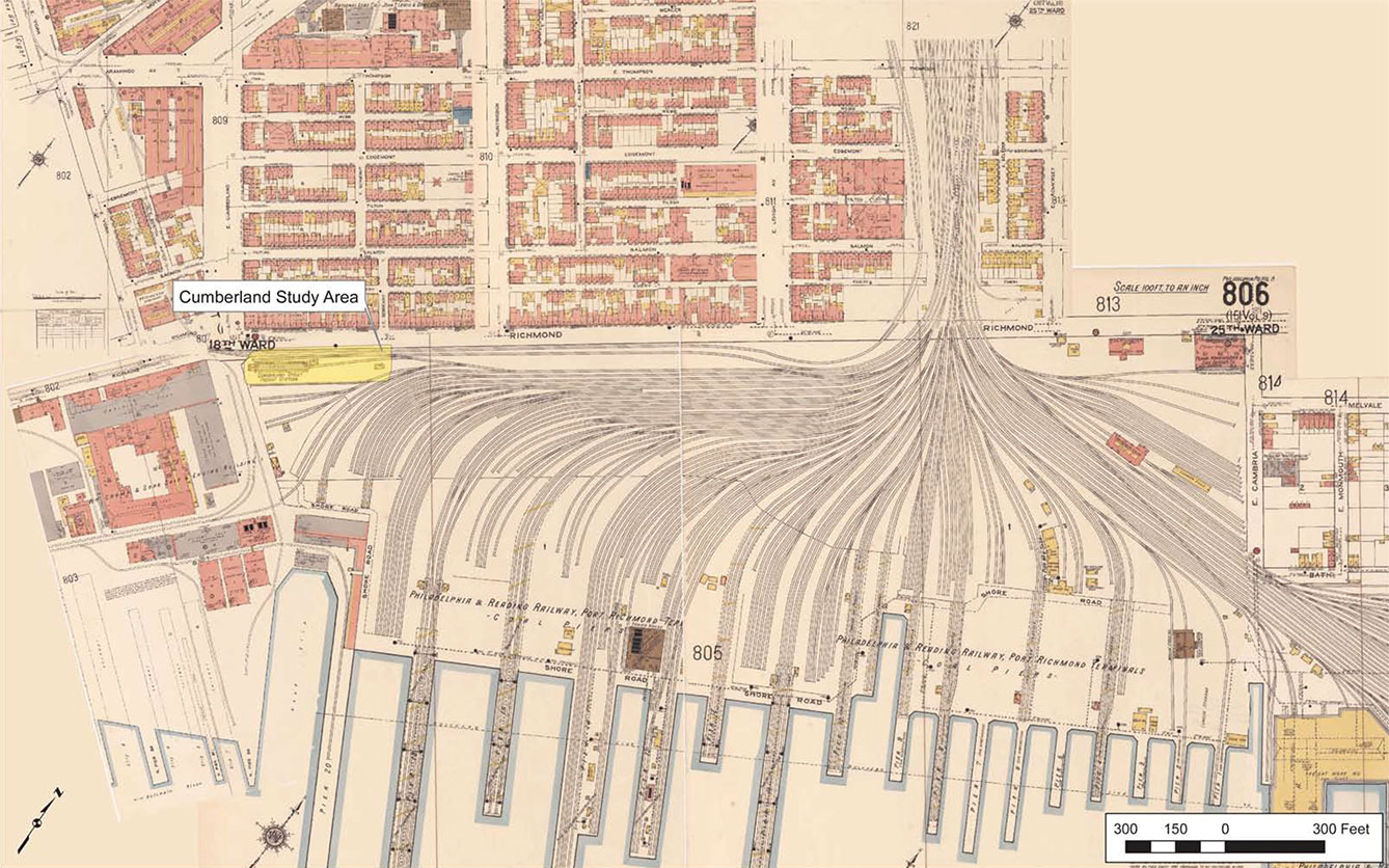
Sometime between 1867 and 1875, lands containing the study area were incorporated into the Reading Railroad Port Richmond Coal Terminal. At this time the study area was likely filled in with several feet of fill to accommodate the laying of track. Within this sprawling complex, the study area location seems to have played a somewhat peripheral role, and was never a part of the main arterial track lines that brought thousands of tons of coal to the riverfront wharves every day (Figure 7). Though a number of small buildings were established in this area over successive decades, available map information suggests that these primarily served as weigh stations and freight platforms, or fulfilled other secondary railroad related functions. The use of this terminal for coal shipments declined after World War II, and eventually most rail lines through the property fell into disuse and were removed (Fisher 1962). Under Conrail’s ownership of this property, beginning in the 1970s, areas in the vicinity of the present study area have been vacated and allowed to become overgrown. Today no active rail lines traverse this portion of the former Port Richmond Terminal property.
Field Methodology
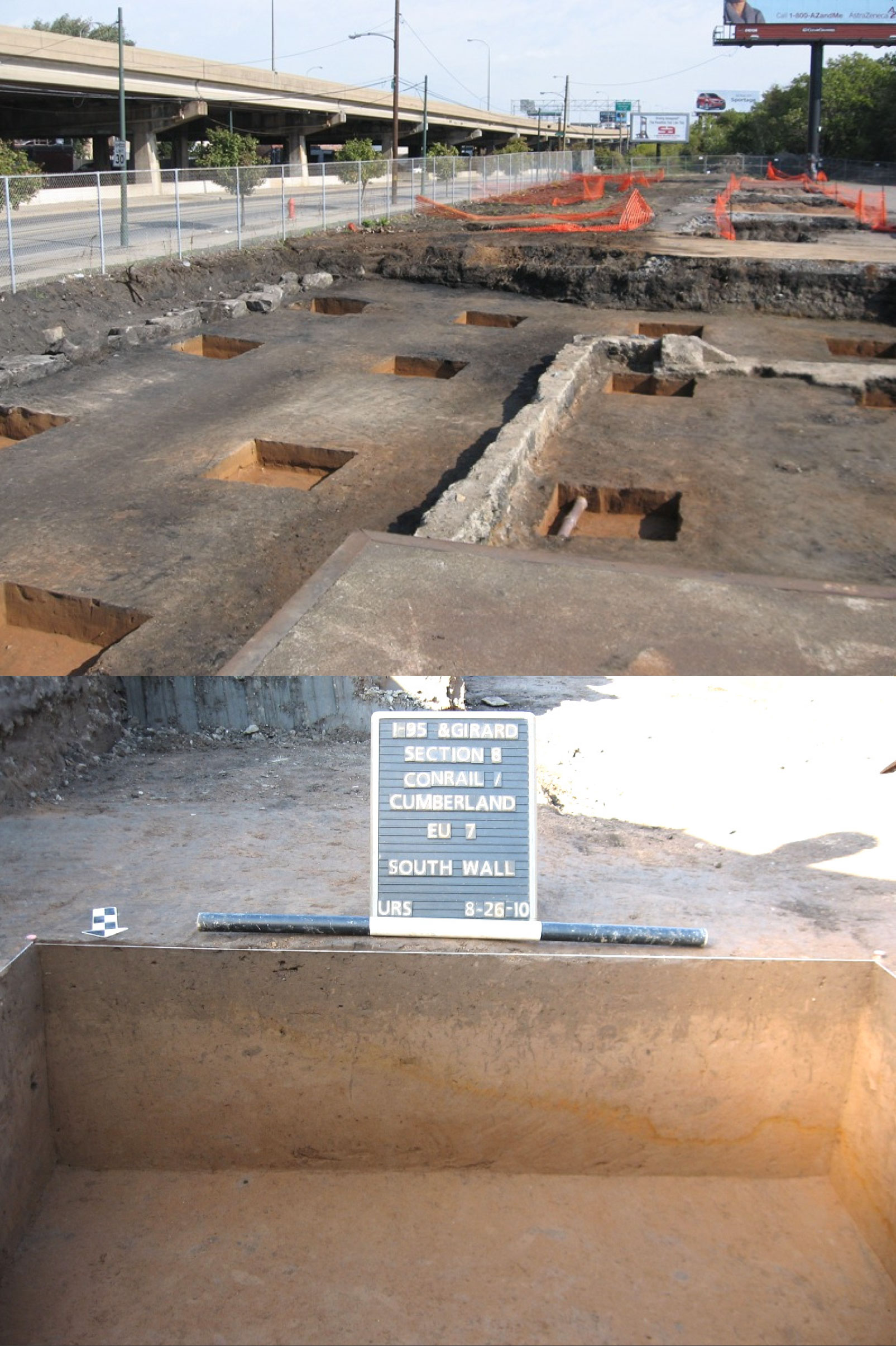
Archaeological testing within the study area was completed using a combination of machine assisted stripping and the hand excavation of 5 by 5 foot square test units. Initial testing at this location involved the excavation of a single exploratory backhoe trench to the northeast of the intersection of Richmond and Cumberland Streets, for the purpose of verifying the presence of intact, artifact-bearing soils and to determine basic subsurface stratigraphy. This first trench was oriented north-south, measured approximately 5 feet by 20 feet in size, and resulted in the discovery of intact deposits of both prehistoric and historic era artifact deposits, as well as buried railroad/coal yard related features. Afterward, backhoe and larger trackhoe machines were used to clear vegetation from the study area, remove near surface obstructions (asphalt paving, Belgian block pavers, railroad ties), and to facilitate hand excavation by stripping overlying fill deposits in select areas down to the top of the former historic ground surface.
Initial controlled testing for intact artifact deposits and features was completed through the systematic excavation of three north-south oriented transects of five-foot square test units. Transects were spaced approximately 40 feet apart, and extended approximately 440 feet north from Cumberland Street. The eastern transect was excavated as a 10 foot wide contiguous trench, while unit locations in the central and west transects were situated in the center of approximate 10 foot square machine stripped excavation blocks. Within each transect test units were placed first at 100-foot intervals, but were subsequently supplemented by addition units spaced at 50-foot intervals. The purpose of this systematic, grid-oriented testing was to determine the distribution and patterning of artifact deposits over the entire and to identify any areas of higher artifact density and/or containing intact subsurface features where more intensive, closer interval testing might be required.
Subsequent more intensive testing within select portions of the study area was completed through the use of both closer interval (10-foot) systematic test unit excavation and judgmentally placed test units. In the latter instances, unit placement was made at the discretion of the supervising field archaeologist, was based on observed or apparent patterns of artifact distribution, and focused on the opening of large contiguous excavation blocks to better allow for the identification of intact subsurface features. Accomplishment of this more intensive testing regimen required the creation of larger test blocks through the machine removal of fill over large portions of the study area. All fill matrix, vegetation, and near surface obstructions cleared during testing were stockpiled along the eastern margins of the study area, and will be re-buried once testing has been completed.
During the completion of site testing, 100% of all excavated soils, from intact soil horizons as well as from identified features, were screened through ¼-inch hardware cloth, and all recovered artifacts were retained in labeled plastic bags pending lab analysis and cataloging. Plow zone soils throughout the study area were excavated as a single layer, while intact subsoils were excavated in arbitrary 0.35-foot/10 cm levels. Feature soils were excavated by observed internal stratigraphy, with no use of arbitrary levels. Unit, artifact, and feature provenience within the study area were established using total station survey equipment in concert with sub-meter accuracy GPS data collectors. All excavation data was fully documented through the use of standardized paper field forms, hand-drawn plan and profile maps, and high resolution digital photography.
Field Results
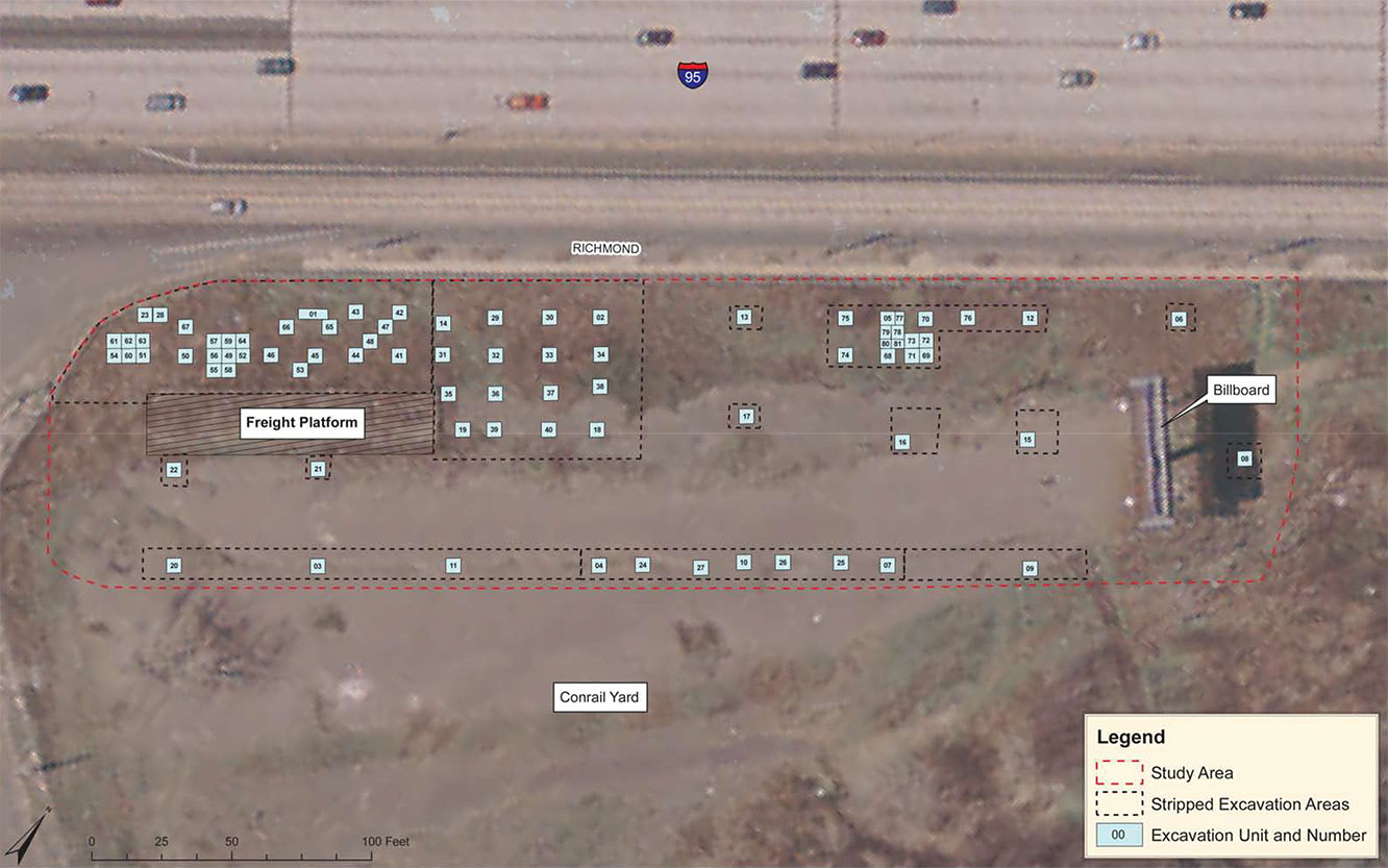
Completion of the Conrail/Cumberland site resulted in the excavation of 81 five by five foot square (1.5 by 1.5 meter) excavation units (Figure 8). Investigations at the site produced an assemblage comprising of a total of approximately 5,000 artifacts, including items of both prehistoric and historical manufacture. Prehistoric cultural materials constitute the single largest class of artifacts recovered from the total assemblage (N=3,056), while historic materials include a variety of domestic and architectural objects potentially dating from the early eighteenth through late 19th centuries.
Site Stratigraphy
In terms of stratigraphy, unit excavation confirmed prior soil boring data and revealed the study area to possess a relatively uniform near surface profile consisting of an upper mantle of railroad related fill (Stratum I) overlying intact plow zone (Ap-horizon; Stratum II), E-horizon (Stratum III), and Bt-horizon soils [Note: soils within the study area were documented by Geomorphologist Daniel P. Wagner; a written report of his findings are pending]. Stratum I railroad fill consisted of varying interfingered deposits of coal ash, cinders, and dense river-dredged clay, and was capped by railroad ties, Belgian block pavers, and asphalt. Testing revealed that this upper fill matrix progressively thickens toward the north, and varies between 2.0-2.5 feet in depth at the southern end of the study area (near Cumberland St.) to some 5.0-6.0 feet in depth in the vicinity of Sergeant St. This pattern of thickening of the upper fill was an intentional element of the rail yard design, and was intended to artificially raise the internal ground surface to meet track grade at the main trestle bridge crossings near Lehigh Ave.
Beneath the railroad fill, testing encountered intact soils throughout the study area, except in portions of the far south end of the project area immediately adjacent to Cumberland and Richmond Streets (Figure 9). In this area intact historic ground surfaces were perforated by a series of stone, brick, and concrete foundations associated with a variety of ancillary railroad related structures and dating to the late 19th through 20th centuries. Disturbances in these instances were confined to relatively limited areas within and surrounding the exposed foundation walls. Unlike the overlying railroad fill, intact soils within the study area tended to be consistently level lying and indicate that historic ground surfaces in this location were more or less flat and featureless.
In other portions of the study area, intact to partially truncated Ap/plow zone soils varied between 0.5 and 1.0 feet (ca. 15-30 cm) in thickness and consisted of 10YR 3/4 dark yellowish brown silt loam. Pronounced, north-south trending plow scars extended below the Ap-horizon into the underlying subsoil. Underlying E-horizon soils were approximately 0.3-feet in thickness (ca. 10 cm), consisted of 10YR 5/4 yellowish brown fine sandy loam, and are indicative of a landform exhibiting long-term deposition and pedological stability. Bt-horizon soils throughout the site consisted of 7.5YR 4/6 strong brown fine sandy loam. Deeper excavation within a selection of test units identified undisturbed glacial outwash till deposits at a depth of some 2.0-2.5 feet beneath the top of the Ap/plow zone horizon.
Prehistoric Site Component
Initial test unit excavations revealed the presence of an expansive, generally low-density prehistoric artifact scatter across the entire study area, and extending outward an indeterminate distance in all directions. In terms of their vertical distribution, the majority of artifacts (N=2,545; 83%) derived from Stratum II Ap-horizon soil deposits, with a somewhat higher proportion of items tending to be recovered from the lower half of this level. The remaining 521 prehistoric artifacts (17%) were recovered from undisturbed contexts within the underlying E-horizon (Stratum III). No artifacts of any kind were identified within the lower Bt-horizon soil matrix.
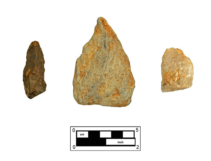
Native American artifacts were represented by pieces of lithic manufacturing debitage, a number of both formalized (diagnostic bifaces) and expedient tool forms (utilized flakes, hammerstones, etc.), and quantities of fire-cracked rock (Table 1). Represented lithic raw materials included quartz, argillite, chert, quartzite, jasper, and sandstone (predominantly hammerstones and fire-cracked rock). Fire-cracked rock (FCR) constituted the single largest artifact category (N=2384; 78.01%). Lithic debitage (N=630; 20.62%) consisted of items representing the full range of stone tool manufacture, from the initial testing of unmodified raw material to the late-stage reduction. Of the identified debitage, 60.63% of the flakes recovered were manufactured of quartz; however, over 70% of that subclass consists of quartz block shatter. Argillite flakes comprised the bulk of the remaining debitage (N=125; 19.84%). Cores and cobble/groundstone tools were only minimally represented, although several hammerstones (N=11) and one small adze were recovered.
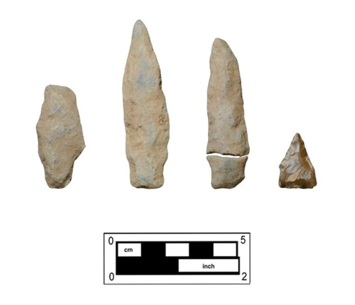
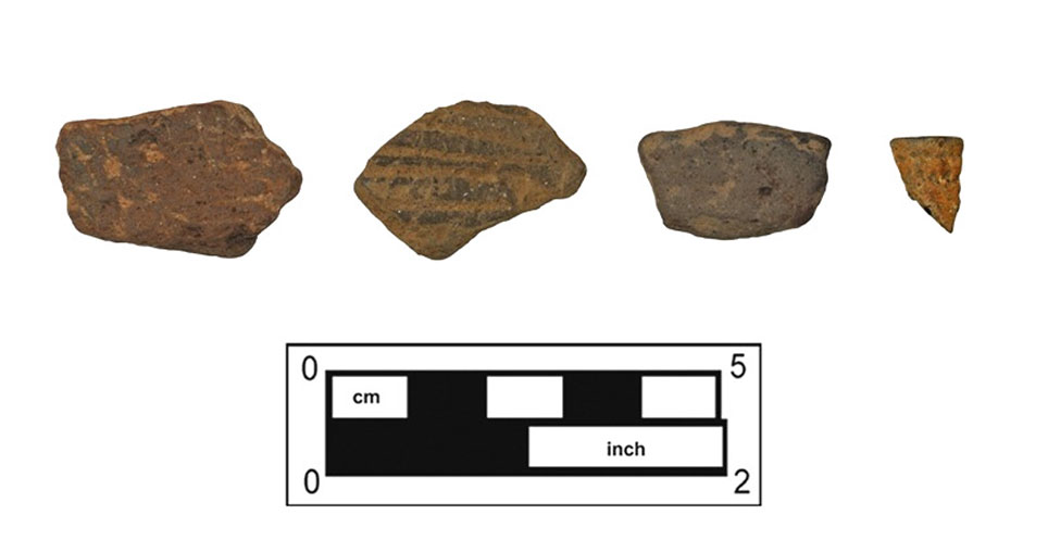
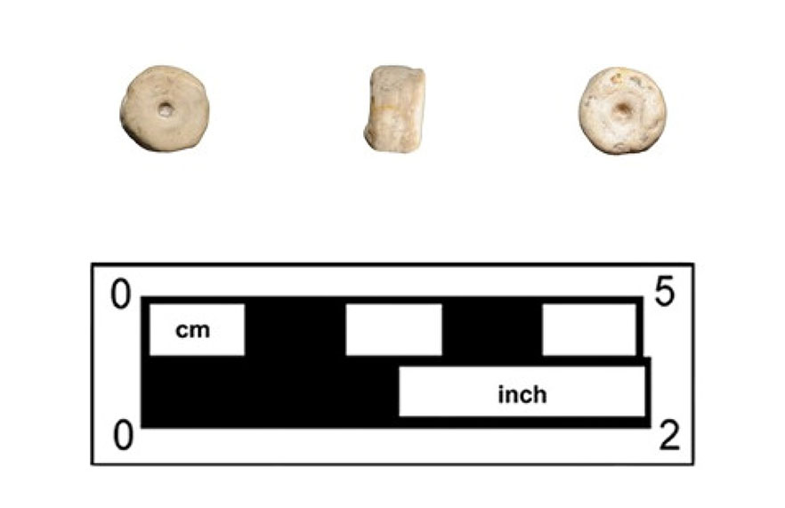
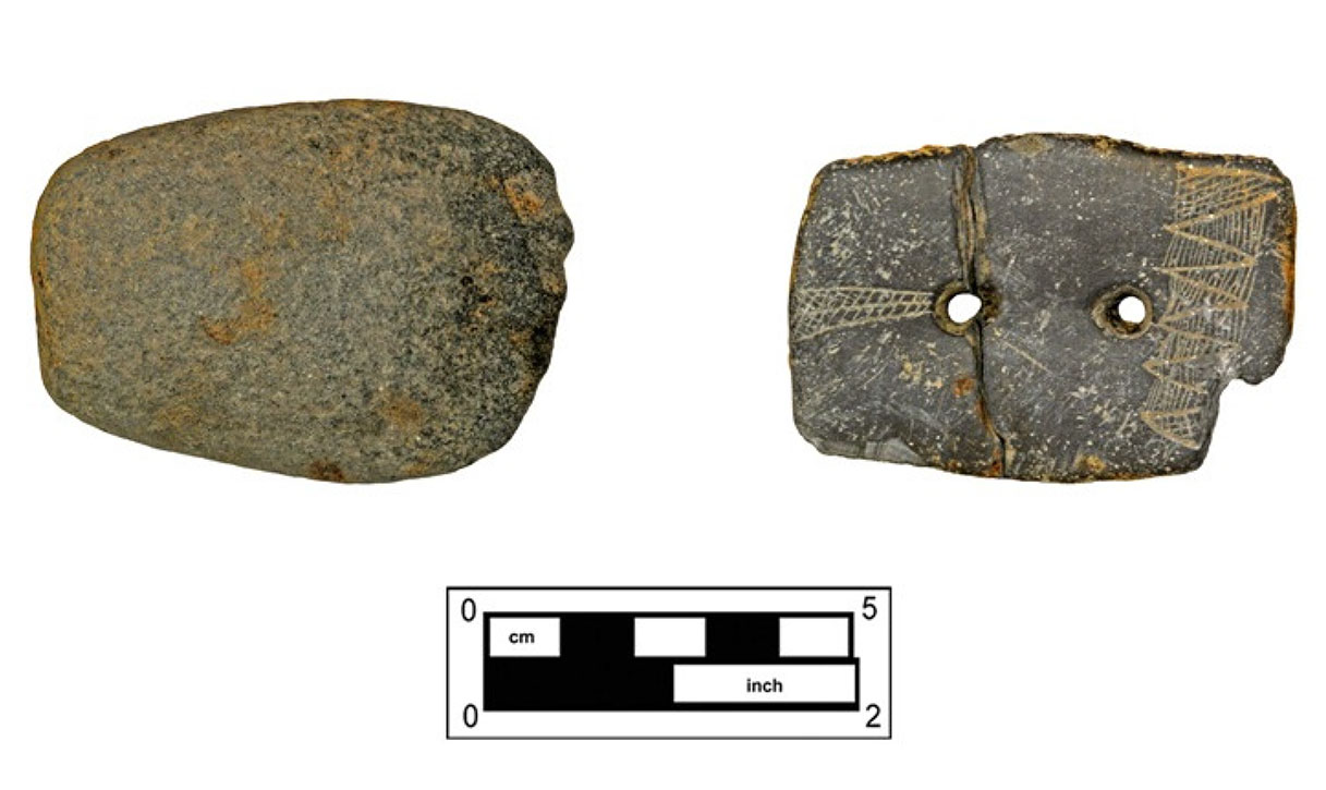
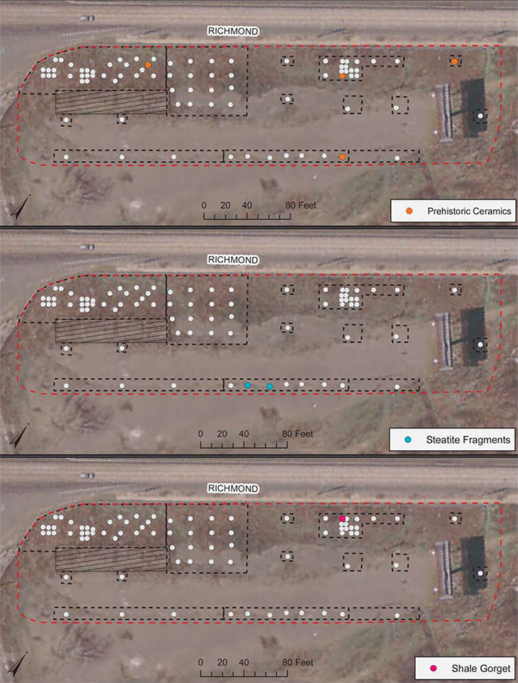
Flaked stone tools from the site were represented by both bifacially and unifacially worked pieces. A total of ten (10) bifacial tools or tool fragments were recovered, including five (5) projectile points and several pieces abandoned in the early through late-stages of manufacture. Of the recovered points, four (4) were stemmed Piedmont-variety points (argillite) and one was a jasper triangular point. Only a small number of unifacial tools (N=6) were recovered, consisting entirely of utilized flakes (Figures 10 and 11). Other notable artifacts recovered included two (2) small, angular steatite fragments, three (3) sherds of prehistoric pottery (cord-marked, incised, and undecorated), one decorated (possibly edge-incised) clay pipe bowl fragment, and one possible shell bead (Figures 12 and 13). Finally, plow zone soils in EU 5 produced one ornamental item – a slate gorget (Figure 14) exhibiting two hand-drilled holes, a series of incised geometric designs on one side, and a cross-hatch pattern along the edges.
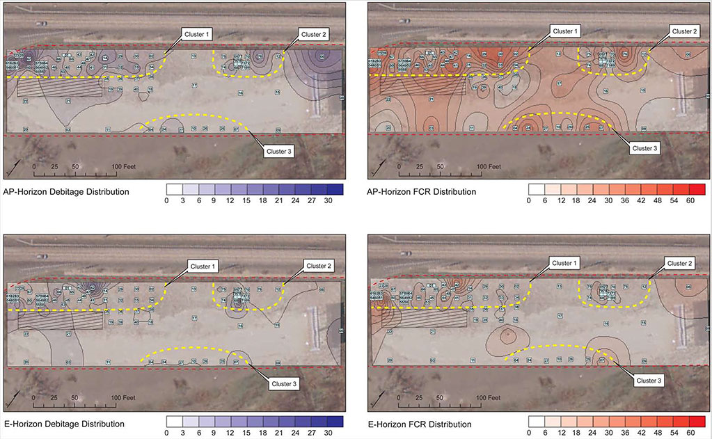

Testing within the study area identified three specific prehistoric loci with somewhat higher density artifact deposits (Figure 15). These clusters are comprised of similar assortments of lithic artifacts, dominated by fire-cracked rock and quartz/argillite debitage, but are also associated with a variety of formal and expedient tool forms, pottery, and/or other potentially diagnostic artifact types (Figures 16 and 17).
Cluster 1, located in the southwest corner of the study area, between the extant freight station and Richmond St., was both the largest artifact concentration and contained the highest density of temporally diagnostic tools, debitage, and fire-cracked rock. Close interval testing within this cluster produced 3 stemmed argillite and one jasper triangular points, numerous unifacial and bifacial tools, quantities of hammerstones, an adze, and a single piece of prehistoric pottery. Cluster 2 was identified further north along Richmond St. and was initially marked by the discovery of the slate gorget. Additional testing resulted in the recovery of a single argillite stemmed point (from E-horizon soils), a handful of hammerstones, and a single piece of prehistoric pottery. Cluster 3, along the far eastern margins of the study area, was initially identified by elevated concentrations of fire-cracked rock and a series of unifacial tools. Additional unit excavation in this location failed to find any higher density artifact deposits, but did turn up 2 pieces of steatite, a piece of prehistoric pottery, one hammerstone, and a few other flake tools.
| Artifact Group | Description | Quantity | % of Total |
|---|---|---|---|
| Debitage | Argillite | 125 | 19.84% |
| Chert | 24 | 3.81% | |
| Jasper | 44 | 6.98% | |
| Quartz | 382 | 60.63% | |
| Quartzite | 55 | 8.73% | |
| Sub-Total | 630 | 20.62% | |
| Cores | Argillite | 2 | 40.00% |
| Jasper | 1 | 20.00% | |
| Quartz | 1 | 20.00% | |
| Quartzite | 1 | 20.00% | |
| Sub-Total | 5 | 0.16% | |
| Unificial Tools | Utilized Flake | 6 | 100.00% |
| Sub-Total | 6 | 0.20% | |
| Bifacial Tools | Biface Fragment | 3 | 30.00% |
| Mid-Stage Biface | 2 | 20.00% | |
| Projectile Point | 5 | 50.00% | |
| Sub-Total | 10 | 0.33% | |
| Cobble/Groundstone Tools | Adze | 1 | 7.69% |
| Chopper | 1 | 7.69% | |
| Hammerstone | 11 | 84.62% | |
| Sub-Total | 13 | 0.43% | |
| Prehistoric Ceramic | Cord-marked | 1 | 25.00% |
| Incised | 1 | 25.00% | |
| Plain | 1 | 25.00% | |
| Pipe Bowl Frag. | 1 | 25.00% | |
| Sub-Total | 4 | 0.13% | |
| Other | Bead | 1 | 25.00% |
| Slate Gorget | 1 | 25.00% | |
| Steatite | 2 | 50.00% | |
| Sub-Total | 4 | 0.13% | |
| Total FCR | 2384 | 78.01% | |
| Overall Totals | 3056 | 100.00% |
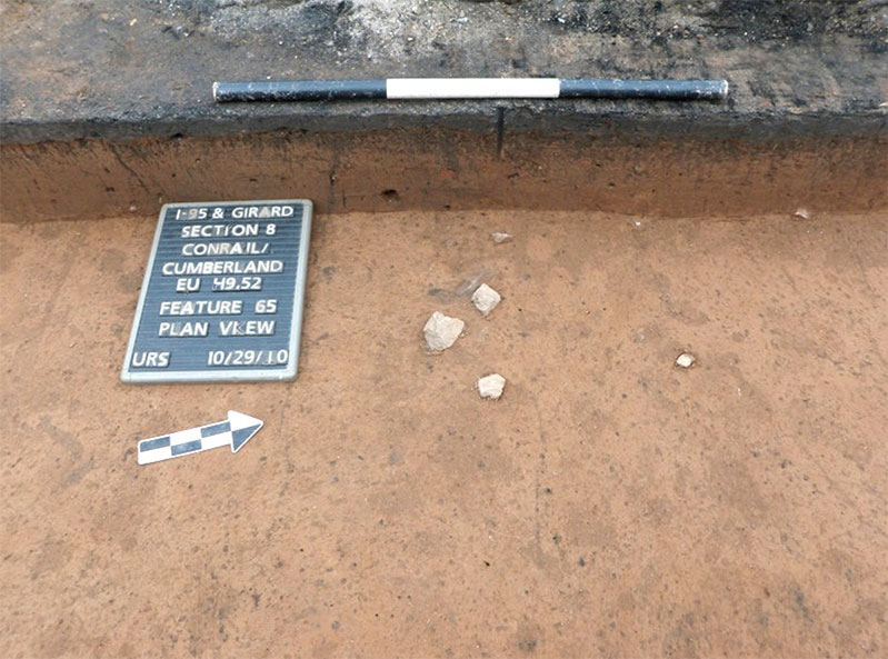
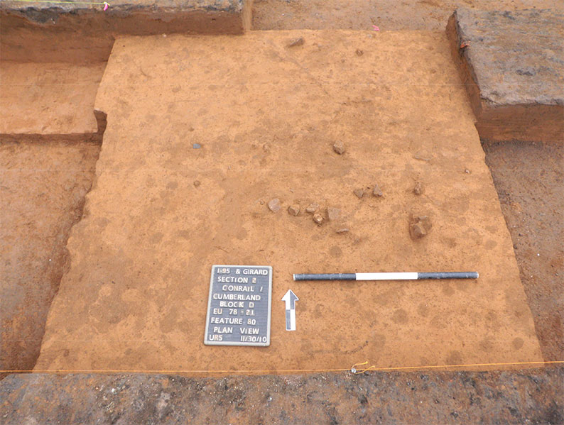
Only two possible intact prehistoric subsurface features were identified within the site, both of which were identified in E-horizon soils. Both were marked by concentrations of apparently in situ fire-cracked rock and appeared to have been substantially truncated by historic-era plowing. The first of these (Feature 65) was identified in EUs 49 and 52 within Cluster 1, and consisted of a small fire-cracked rock (FCR) grouping with small amounts of associated charcoal. Artifacts from the feature consisted of FCR (N=16), one jasper flake, and one quartzite flake. A charcoal sample was collected from the feature and has been submitted for C-14 dating. The second feature (Feature 80; EUs 78-81) was identified within Cluster 2 and contained a large (ca. 6.0 feet x 7.5 feet) concentration of FCR (N=58), along with quartz shatter (N=48), two (2) argillite flakes, and one jasper flake. Charcoal was inconsistently scattered throughout the feature matrix and two charcoal samples were collected (one submitted for C-14 dating). Both features were shallow (< 0.3 feet / 10 cm) and did not extend into underlying Bt-horizon soils (Figures 18 and 19).
Historic Site Component
Like prehistoric artifacts, historic period artifacts were also recovered over the entire study area. For the purposes of this management summary, these items can be lumped into two broad categories based on their likely historical association: pre-railroad and railroad related. Pre-railroad related artifacts were identified exclusively from plow zone soils (Stratum II), while railroad/coal yard artifacts were recovered either from the surface of the plow zone or, more commonly, in association with features of one kind or another that extended into intact soils from the overlying fill horizons (Stratum I).
Pre-railroad historic artifacts consist of items with manufacture dates that pre-date the incorporation of the study area vicinity into the Port Richmond Coal Yard, and consist of an expansive and comparatively diffuse distribution across the study area. In overall appearance, this assemblage of materials generally appeared consistent with random “field scatter” deposits commonly found in agricultural fields throughout southeast Pennsylvania. Pre-railroad historic artifacts were largely represented by small, fragmentary ceramic and glass domestic refuse, as well as smaller quantities of architectural debris such as window glass and nails (predominantly machine-cut). Potentially diagnostic ceramic sherds date to the 18th through 19th centuries and are represented by an assortment of redwares (unglazed, Staffordshire, black and brown glazed, trailed-slip decorated) and whitewares (undecorated, blue and black-transfer, lusterware), with significantly smaller quantities of pearlware (undecorated, polychrome), creamware (undecorated), tin-glazed, and stoneware. Military/personal items recovered included gunflint fragments (N=8; French variety) and two (2) lead musket balls.
Although pre-railroad artifact deposits generally exhibited a non-specific, random pattern of dispersal throughout the plow zone, one localized concentration of historic materials was identified. Corresponding with the location of prehistoric Cluster 3, this grouping was represented by higher than normal concentrations of architectural debris (window pane glass and nails). More intriguingly, artifacts in this cluster included a number of items that appear to exhibit very early manufacture dates, including possible rose-head nails and ceramics sherds such as Staffordshire. Interestingly, this historic cluster does fall in relative proximity to the mapped location of Anthony Palmer and William Ball’s “Hope Farm/Richmond Hall” estate homes. Though far enough removed that these artifacts are unlikely to be directly related to that structure, it is possible that they are associated with one or more of the outbuildings and dependencies known to exist on this property. Unfortunately, a series of tighter interval test units clustered in the location thus far have produced no indications of any features that might be associated with an early domestic structure.
A total of seventy-nine historic features were identified, most of which clearly date to the late 19th or early 20th centuries and are associated with the operation of the rail yard. Railroad/coal yard features are represented by a series of stone building foundations, post holes and molds, remnants of a 19th century timber freight platform, along with a variety of drainage ditches or utility trenches. Artifacts within these features were dominated by architectural items (nails, spikes, brickbats, plaster, cement, wood, and unidentified metal fragments). Domestic glass or ceramic artifacts were only rarely found in association with these features and were extremely limited in their overall variety (milk glass vessel fragments, machine-made glass bottle fragments). All suspected railroad related features within the study area occur in areas where historic maps identify coal yard structures to have once existed.
Conclusions and Recommendations
Phase IB/II investigations within the Relocated Richmond Street ROW, between Cumberland Street and Sergeant Street, resulted in the identification of a single archaeological site containing both historic and prehistoric components. This site, designated the Hope Farm-Richmond Hall Site after the names of the earliest historic period estates in this location, covers the entire current study area (ca. 1.0 acres) and extends outside of these boundaries in all directions. To the east, the site likely extends all the way to the historic river edge, while to the north, west, and south the full extent of site related deposits remains undetermined. Based on data collected during the testing of this site, associated intact artifact deposits and features could be contained beneath the adjacent active city streets and the extant I-95 corridor. Interpretations and recommendations contained in this document pertain only to those portions of the site that fell within the present study area. Portions of the site outside these limits will need to be separately tested and evaluated if they are impacted in the future.
Intensive archaeological testing resulted in the recovery of some 3,056 prehistoric artifacts. It was further determined that the Hope Farm-Richmond Hall Site Native American component was contained primarily within a buried, primarily intact Ap-horizon, although a smaller number of artifacts were also found in the upper portion of the underlying, intact E-horizon. The prehistoric component was represented by an assemblage of lithic and ceramic artifacts, as well as two fire-cracked rock clusters. The artifacts consisted primarily of fire-cracked rock and debitage of various materials. One triangular and four stemmed points were recovered. Both point types were used throughout much of prehistory but as an assemblage they suggest occupation between the Middle Archaic and Early Woodland periods (ca. 5,500 B.C. – 100 A.D.). Three ceramic sherds and a clay pipe fragment indicate Woodland period occupation (ca. 1,200 B.C. – 1550 A.D.). The ceramic artifacts were found in widely scattered locations and are not classifiable by type. Two steatite fragments were identified in adjacent test units. Steatite is relatively rare in the Delaware River drainage and is currently reported at only 15 sites. Since the material is often associated with Orient fishtail points, the two steatite artifacts may indicate the presence of a Transitional Archaic occupation (ca. 1,800 B.C. – 1,200 B.C.). Tools other than points included six utilized flakes, bifaces and biface fragments, hammerstones, an adze, and a chopper. The relatively low artifact density and wide temporal range of the diagnostics suggest that the site is the product of multiple short-term occupations.
The site contains significant information on the prehistory of the region because it is one of a very few prehistoric sites preserved along this stretch of the Delaware River. Despite the fact that the full extent of the associated artifact scatter remains indeterminate, this site represents the largest known Native American occupation thus far discovered within the City of Philadelphia. Although the site has been plowed and has been locally disturbed in places by construction of various railroad/coal yard related structures, the prehistoric land surface is generally well preserved below surface fill deposits; therefore, the site retains integrity. For these reasons, as well as for its ability to instruct and inform present-day residents about the long and vital record of Native American Heritage within the confines and environs of the historic city, the prehistoric component of the Hope Farm-Richmond Hall Site should be considered eligible under Criterion D for listing on the National Register of Historic Places.
The historic period artifacts from the site were recovered from Ap-horizon soils and from a series of 79 subsurface features, and are represented by approximately 2,000 individual objects. The largest proportion of these materials consists of highly fragmentary ceramic and glass artifacts exhibiting a wide range of manufacture dates (early 18th through late 19th century) that were deposited prior to the incorporation of this location into the Reading Railroad’s Port Richmond Coal Yard. These pre-railroad artifacts form an expansive, low-density, randomly distributed midden across the entire study area, and likely represent “field scatter” deposits that gradually accumulated during the first 200 years of historic occupation in this vicinity. A small concentration of historic artifacts along the eastern margins of the study area includes quantities of ceramic and architectural objects manufactured during the first half of the 18th century that could be associated with the nearby Hope Farm-Richmond Hall estates of Anthony Palmer and William Ball. Evidence generated by this investigation suggests that subsurface remains of those estates, and their associated dependencies, are likely preserved in adjacent areas of the present day Conrail Yard property; however, these areas will likely not be impacted by I-95 construction related activities.
All of the historic features within the study area, represented by stone, brick, and concrete building foundations, a timber freight platform, and numerous post holes and utility trenches, date to the late 19th and 20th centuries and are associated with the operation of the Port Richmond Coal Yard. This specific location was contained within a remote, ancillary section of the larger coal yard, where the primary activities seem to have involved the loading and unloading of a variety of freight. The features themselves contain few artifacts that are non-architectural in nature and for the most part only serve to confirm information contained in historic maps of the coal yard. As such, the identified features are not believed to constitute an archaeological resource that is eligible for listing in the National Register. Other portions of the former Port Richmond Coal Yard outside the present study area are likely to contain significant archaeological deposits and features that more directly relate to the operation and growth of this industrial property. The potential eligibility of these resources will need to be evaluated by future investigations.
Work completed at the site to date has involved the excavation of 2,025 ft2, representing approximately 4.6% of the total study area, and has resulted in the recovery a sample of sufficient size to characterize the overall prehistoric and historical assemblage. It is unlikely that further excavation would provide artifacts in number or type to add information to what has already been recovered. Therefore, no additional test unit excavation is recommended. However, because additional potentially significant prehistoric and historic features could be contained within unexcavated portions of the study area and site, it is recommended that mechanical stripping of the plow zone be conducted in selected locations, to be determined in consultation with PennDOT and the PHMC. Based on the findings thus far generated, URS recommends that stripping be confined to the locations defined by artifact Clusters 1-3. In Clusters 1 and 2, stripping and shovel scraping of the exposed subsoil could facilitate the identification and documentation of any additional Native American features that might be present. In Cluster 3, stripping operations have the potential to uncover prehistoric features, and would also permit a more intensive examination for any historic features potentially associated with the adjacent Hope Farm and Richmond Hall estates. Following completion of the mechanical stripping, it is believed that all significant information will have been recovered from the Hope Farm-Richmond Hall Site and no further work (i.e., Phase III data recovery) would be required.
Figures
References Cited
Milano, Kenneth W.
2009 “Anthony Palmer, Hope Farm, and the Founding of Kensington”. Encyclopedia Kensingtoniana (website; accessed December 2010).
http://kennethwmilano.com/page/Encyclopaedia/18thCenturyKensington/AnthonyPalmerandtheFoundingofKensington/tabid/114/Default.aspx)
Fisher, Barbara
1962 “Maritime History of the Reading, 1833-1905”. Pennsylvania Magazine of History and Biography, Vol. 86, No. 2, pp.160-180.
Historic Maps
Grover, Joseph
1753 Untitled manuscript survey of the William Ball estate. Philadelphia City Archives, Philadelphia. PA.
Hassler, F.R. and A.D. Bache, Superintendents
1843 U.S. Coast Survey from Philadelphia and Camden North, PA & NJ. U.S. Coast Survey (Washington, D.C.).
Sanborn Map Company
1916 Atlas of the City of Philadelphia. Sanborn Map Company, New York, NY.
Sidney, J. C.
1849 Map of the City of Philadelphia Together with all the surrounding Districts, including Camden, N.J. [From Official Records, plans of the district surveyors & Original Surveys by J. C. Sidney, civil engineer & surveyor]. Smith & Wistar, Philadelphia.