Archaeological investigations within the alternate mitigation area, and intended to expose and document a large section of the former Aramingo Canal prism and outer timber walls, were conducted during the winter of 2007–2008. When completed, these excavations succeeded in exposing, in both a literal and visually dramatic sense, several key elements in the layered industrial history of the Kensington and Port Richmond neighborhoods. As is often the case, however, things did not go completely as anticipated, and, in the end, the data-recovery plan crafted to guide the excavations did need to be revised slightly after work began. A variety of factors also conspired to make the documentation of the canal more problematic than was initially hoped for, and required a combination of stubborn perseverance and the implementation of creative solutions to allow the work to continue. Once all was said and done, however, these various problems actually worked to benefit the study of the canal, and resulted in a more thorough documentary effort.

Initial Phase III trenching revealing twentieth-century brick foundations.
The original plans for the data-recovery investigations (Phase III) targeted the east side of the canal, directly opposite from that section exposed in the earlier Phase IB/II testing (Trench 3). In that way, portions of the intact timber canal wall, the bottom of the canal channel, the Norris Street bridge abutment, and the coffer dam could be more fully exposed and documented. Unfortunately, early on in the work, a series of significant obstacles were encountered in the vicinity of the abutment that prevented the extension of excavations as far north as projected. These obstacles included large abandoned sewer lines, a substantial brick-and-concrete manhole, and massive slabs of stone and concrete. Blocked off to the north, excavations instead were extended farther to the south, where no such impediments were found, and investigations shifted away from the abutment and coffer dam to focus more on the canal structure itself.

The east wall of the canal emerging from fill within the interior of the brick foundation.
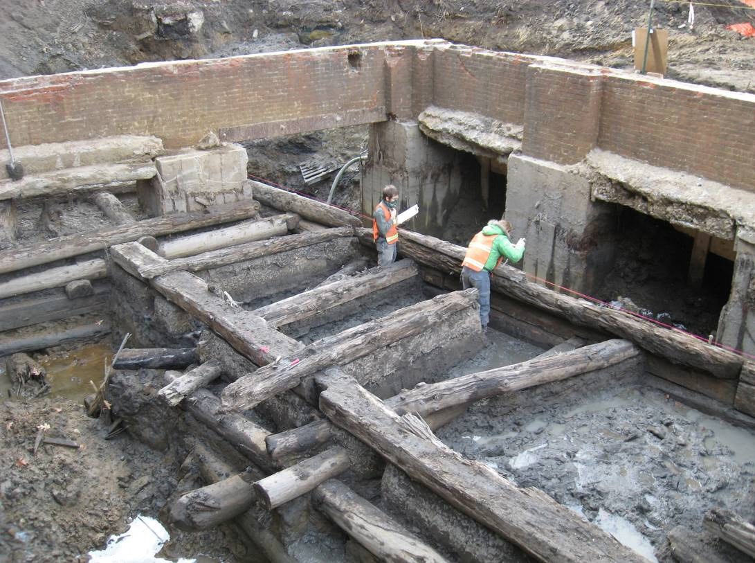
The other issues affecting the excavations emerged quickly as the first trenches were expanded down to the canal level. First among these issues was the unexpected appearance of a sizeable brick-and-concrete building foundation framing the area where the canal wall was being exposed (Figure 4.1). Associated with a series of early-twentieth-century buildings from the former Cramp shipyard complex, these foundations extended farther to the west than historic maps at first seemed to indicate, and posed a major stumbling block to the mechanical excavation of the underlying canal wall (Note: previous Phase IB/II testing to locate the east side of the canal had been performed in the middle of these foundations, and so their presence was not detected at that time). Representing a historical resource in their own right, the foundations could not be simply removed, but rather had to be carefully worked around as the canal was exposed (Figure 4.2).

Hand-excavating fill from within the east canal wall structure.
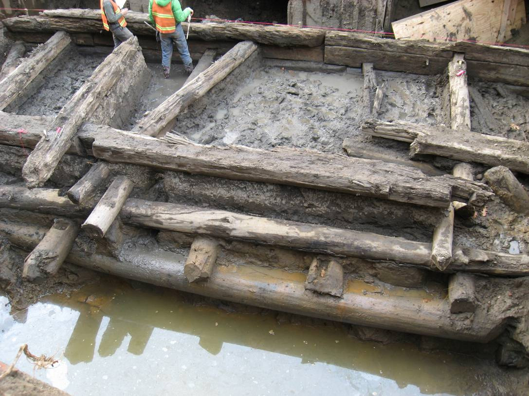
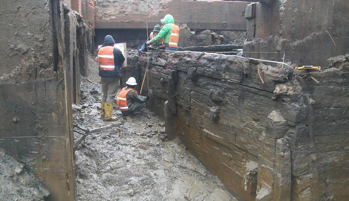
More troublesome to excavators was the excessive water encountered at the level of the canal (approximately 8 feet below ground surface) and that still, to this day, continues to flow within its buried walls. Investigations were only possible through the use of near-constant pumping to keep the water level sufficiently depressed so that exposed canal elements could be documented and recorded. Each night the excavations refilled with water, so that the pumping process had to be repeated daily. To make things even more difficult, the water saturated the fill material in the canal channel and transformed it into a thick slurry that flowed back into the excavation almost as quickly as it was removed with excavation equipment. Within the canal wall’s wooden framing, thick, sucking mud repeatedly claimed the boots of archaeologists hand-excavating otherwise unreachable areas between the exposed timbers (Figure 4.3). Fortunately, despite the ever-present wetness of the site, the project crew suffered only two “full-body immersions” into the icy cold, murky canal water—and that turned out to be the same person who fell in on two different occasions.
Despite these difficulties, the final results were worth the effort. Once completed, the data-recovery excavations succeeded in exposing an approximately 52-foot-long, very well preserved section of the east canal wall, foundations associated with one of the Cramp shipyard factory buildings that had been built partially over the canal in the first decade of the twentieth century, and a handful of other related structures (Figures 4.4, 4.5, 4.6). In the end, a larger portion of the canal wall was exposed and documented than originally planned. This, in turn, provided for more robust insights into questions about how the canal was constructed and the nature of its use. For the residents of the local neighborhoods who visited the site on occasion, the excavations and their findings imparted an indelible lesson about the nature of archaeological preservation in Philadelphia.
Cramp Shipyard Foundations
 map showing location of the Phase III excavations.")
Sanborn Fire Insurance (1919) map showing location of the Phase III excavations.
Foundations associated with the former William Cramp and Sons Ship and Engine Building Company were exposed just a few inches below the existing ground surface and defined a structure with exterior dimensions measuring 48 feet (north-south) x 30 feet (east-west) in overall size. This structure consisted of a brick grade beam resting on six large, poured concrete support piers. The grade beam itself was 1.5 feet (18 inches) wide and extended approximately 4 feet into the ground. The space between support piers was additionally reinforced using steel I-beam bridging built into the bottom of the brick grade beam. Of the supports, four were located along the west side of the foundations and one each at the center of the north and south walls, with these piers extending an unknown distance below ground. No evidence of any basement level or interior flooring was found within these foundations; instead, the space within and below the grade beam was filled with mixed soil and construction rubble deposits to a depth of about 8 feet below ground surface. To the east, the exposed foundations were tied into another pier-supported brick grade beam belonging to an even larger section of this building. This eastern building section did contain an “at grade” poured concrete floor, situated immediately below the existing ground surface, and also appears to have been built with no basement level.
A review of historic maps for this location revealed that the foundations encountered in the excavations belonged to the “Machine Shop” building the Cramp company constructed in the early twentieth century. More specifically, these exact foundations corresponded to a small extension to that larger building complex labeled “Toilets & Lockers” on 1919 city maps (Figure 4.6). Initial expectations were that the machine shop building had extended from Richmond Street to a point just east of the former canal alignment, and therefore would not be contained within the Phase III excavation area. As it turns out, however, the toilets and lockers section partially overlapped the eastern margins of the canal, and extended several feet into the old canal prism. Astonishingly, the construction of this building was accomplished with comparatively minor disturbance of the underlying canal structure. Subsequent excavations indicated that the upper few feet of the wooden canal wall had been truncated to accommodate the installation of the brick grade beam, but that only the north and south central pier supports had to some extent impacted more deeply buried portions of the canal’s timbers. Even then, pier-related impacts were fairly minimal, and were limited to only that space the piers directly occupied.
Eastern Wall of the Aramingo Canal
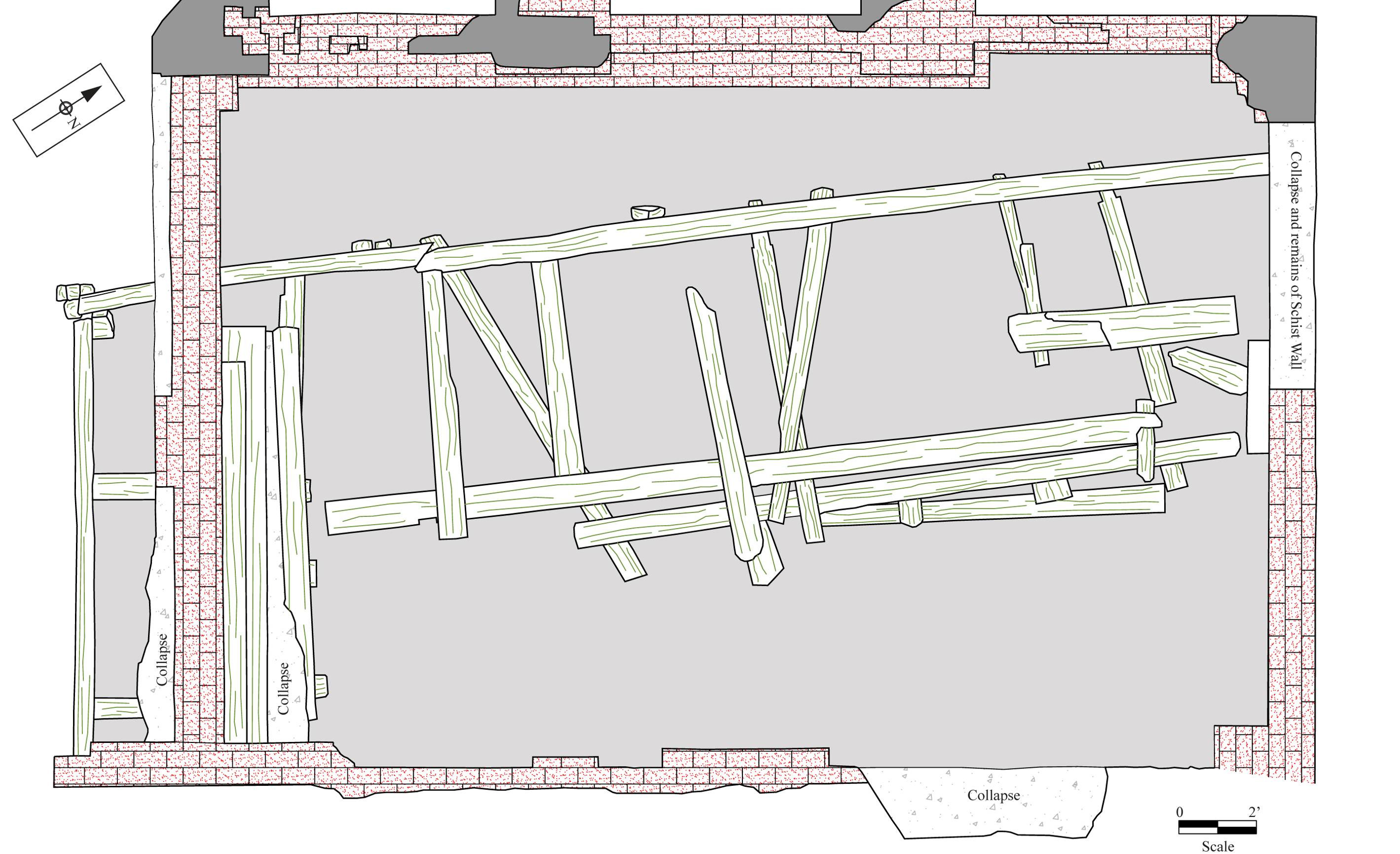
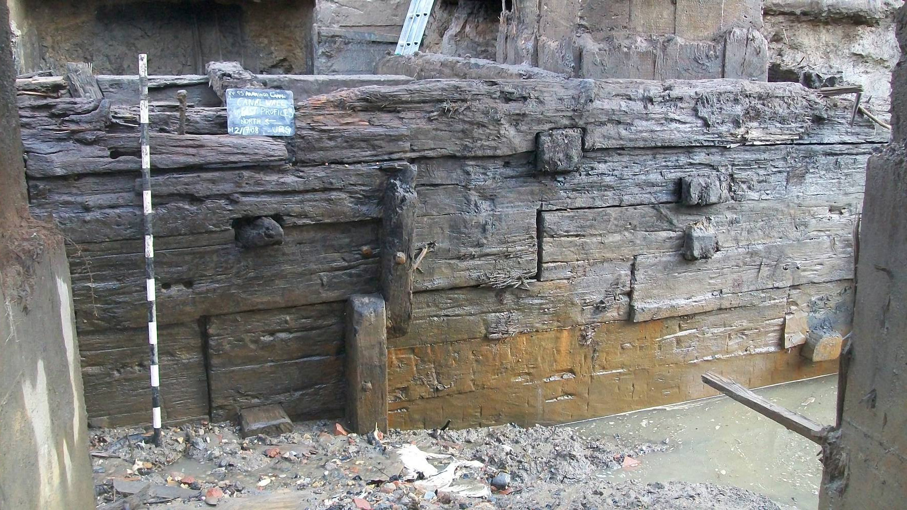
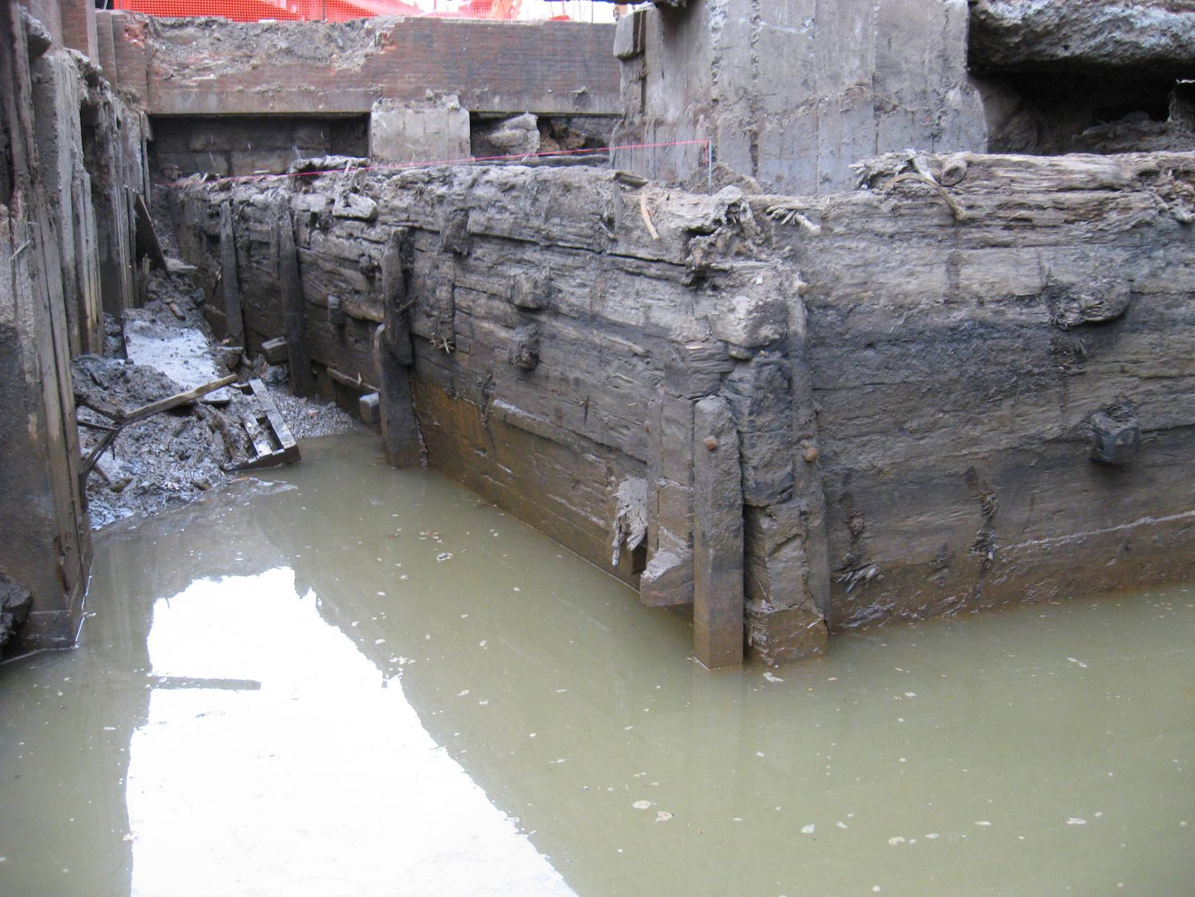
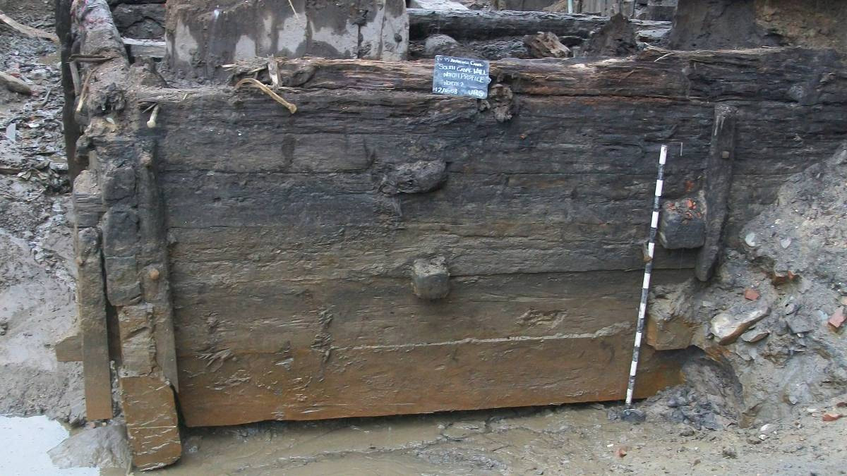
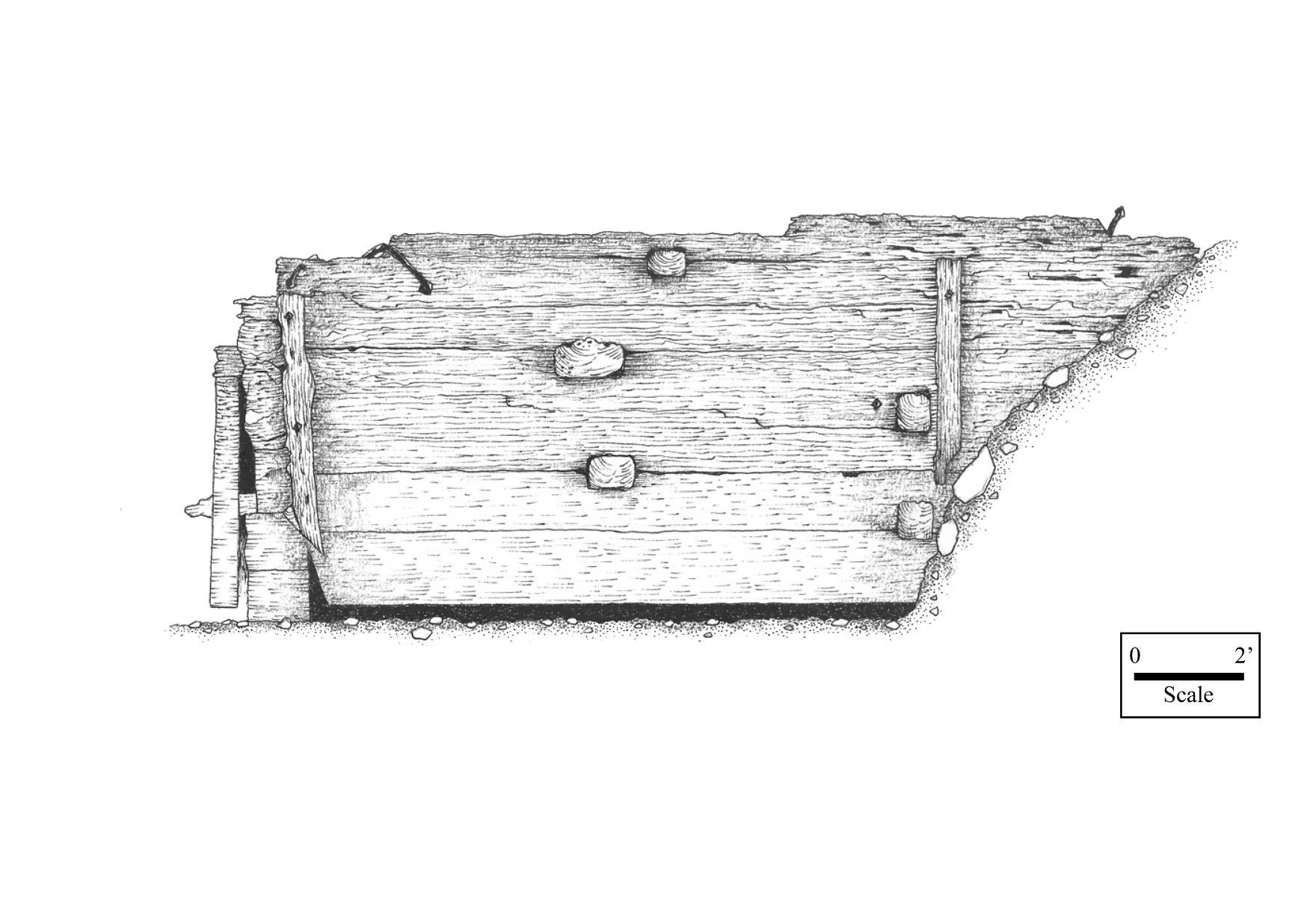
The wooden wharf structure that formed the canal’s eastern wall was uncovered at a depth of approximately 8 feet below ground surface and consisted of two distinct components that, taken together, formed an L-shaped configuration in plan view (Figure 4.7). The longest exposed section of the wall measured 52 feet in length, extended through the center of the Cramp machine shop’s toilets and lockers foundations, and represents what had once been the outer wall of the main canal channel. This segment was aligned slightly askew of the foundation’s north-south axis, running approximately 10 degrees more toward the north. At the south end of the excavation, a second, perpendicularly oriented (east-west trending) timber wall segment joined the first at an angle of slightly greater than 90 degrees. This second section ran partly beneath and partly outside of the southern Cramp foundation, and represented the northern side of what historically had been a watered inlet extending off of the main canal channel (Figure 4.8).
.")
Detail of an 1875 survey map showing the relationship of the Phase III excavation area to former inlets extending off the main canal channel (Source: Hopkins 1875).
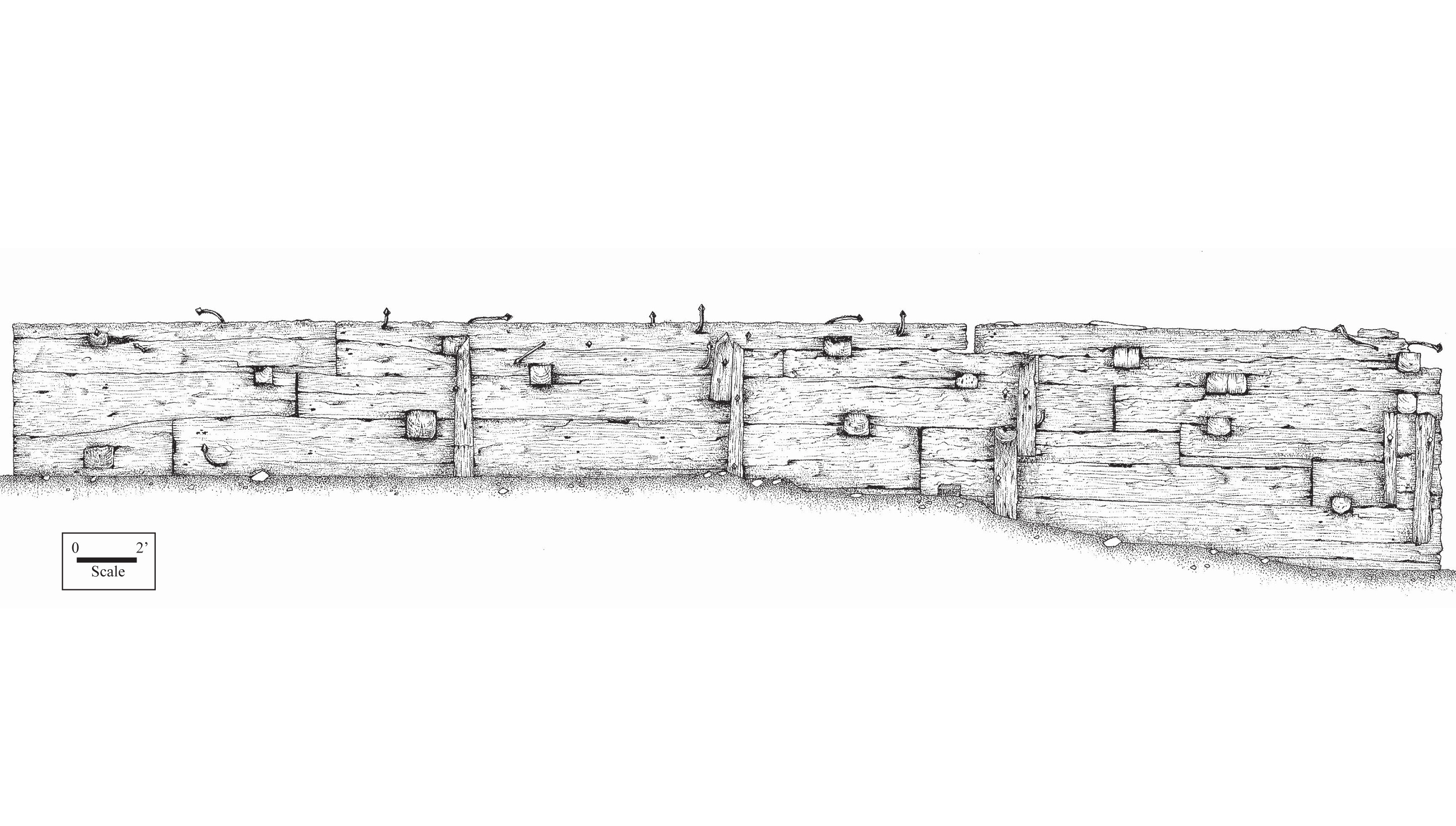
Work to more thoroughly expose these wall segments revealed them to consist of a lattice-like network of timber beams, or cribbing, formed into two parallel longitudinal components, spaced approximately 10 feet apart, and connected via lateral crossbeams (Figures 4.9, 4.10, 4.11). The far western and southern longitudinal components consisted of the timber outer walls of the main canal channel and inlet, respectively, and represented the only elements of this structure that would have been visible to someone traveling in the canal. Portions of the structure behind these main walls consisted of those elements that served to anchor the outer walls into the surrounding earthen bank, and would have been concealed entirely below ground.
Excavations within the former open water prism and inlet of the canal to expose the outer wharf walls extended to a maximum depth of approximately 8 feet below the top of the canal timbers. Digging was terminated at this depth because of an inability to further suppress groundwater, and because the bottommost timbers of the wall had been successfully exposed. Fill within the canal channel was very similar to that encountered in Phase IB/II Trench 3 and consisted of random interfingered layers and pockets of soil, ash/cinder, and construction rubble. Beneath this fill, machine excavations encountered concentrations of stream cobbles in a reddish clay matrix, which likely represented the original bottom of the canal prism. No artifact-bearing deposits were identified within the former prism. Interior sections of the wharf structure were excavated to a maximum depth of some 5 feet below the top of the timbers. The fill matrix encountered behind the main canal walls consisted of a thick, heavy gray clay/silt very similar to that found within the Trench 3 coffer dam, and that would have served to make the outside of the canal channel water tight.
As hoped, data-recovery excavations revealed much information about how the wharves bounding the canal were constructed. The outer walls of the wharf structure, which fronted on the canal prism and open water inlet, were constructed of shaped, rectangular beams fitted tightly together to prevent water loss, forming a solid face approximately 8 feet high. Large iron pins or spikes were driven through these beams in order to provide added structural strength. A series of upright supports were attached to the outer face of this wall at regular intervals, and affixed using iron spikes (Figures 4.12, 4.13, 4.14, 4.15).
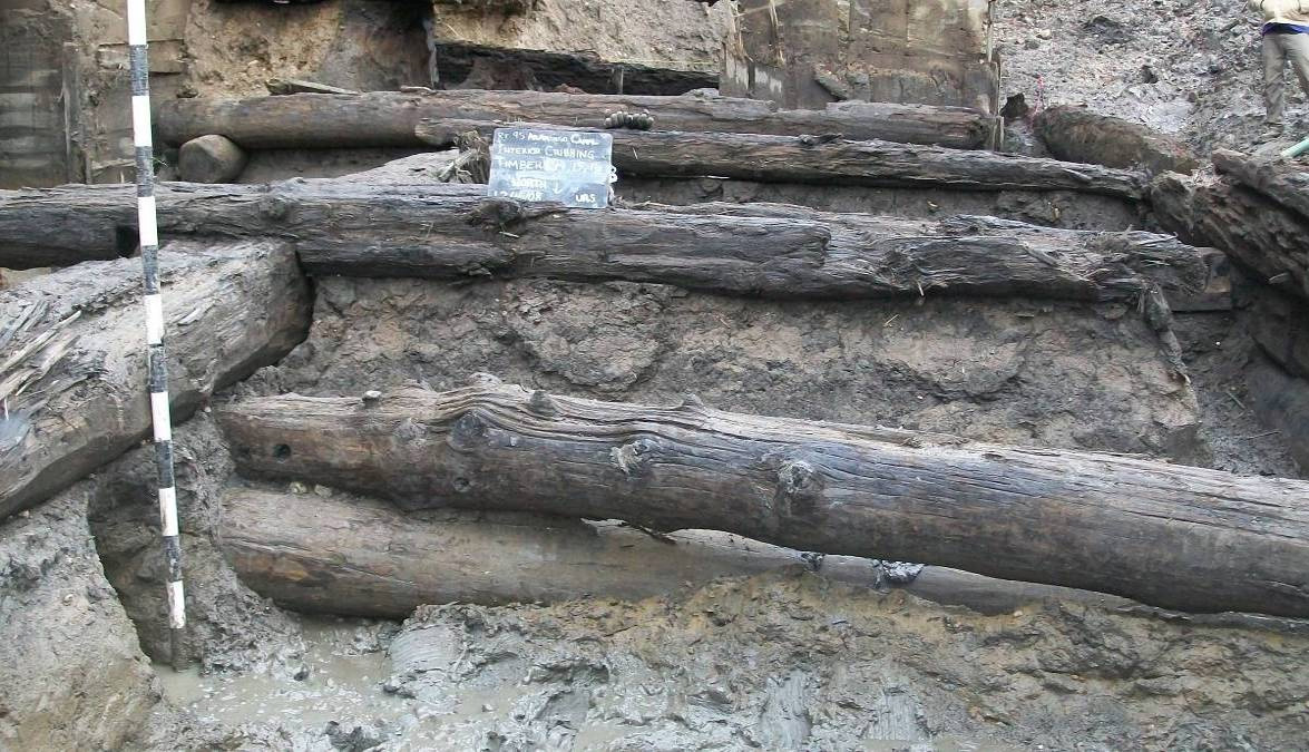
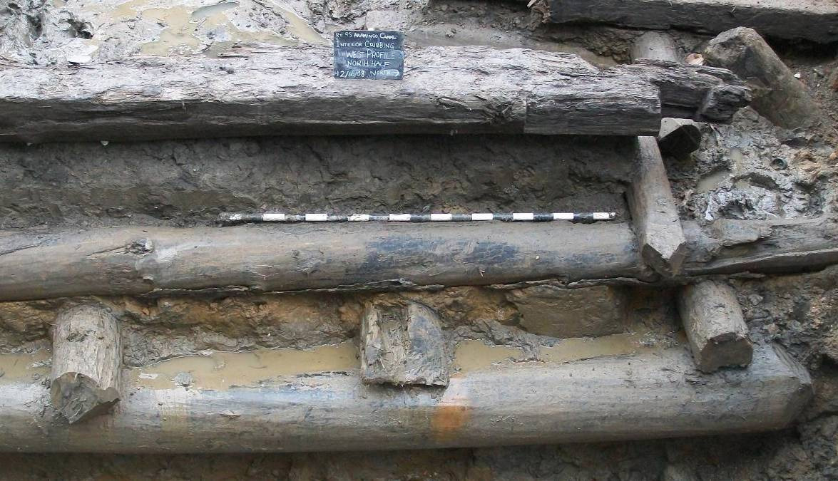
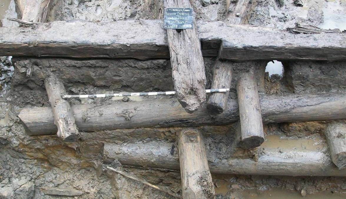
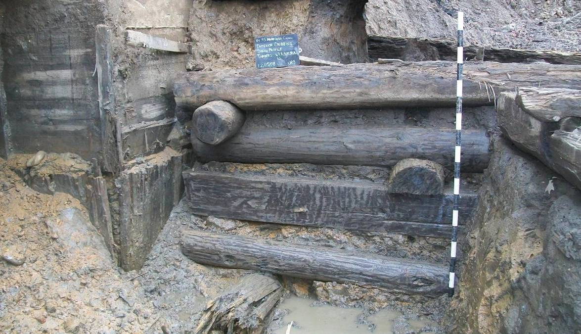
Interior, or landside, portions of the wharf structure exhibited a somewhat different manner of construction. Since this cribbing was built to retain the land behind it, and water leakage was not a concern, the timbers in this portion were configured in a more open “Lincoln-log”-like manner (Figures 4.16, 4.17, 4.18, 4.19, 4.20). In this part of the wharf, the longitudinal beams (called headers and arranged parallel to the outer wall) and crossbeams (stretchers) consisted of an assortment of both modified and unmodified timbers. Most of the header and stretcher beams were represented in round, rough logs with little or no evident trimming or round trimmed logs; however, shaped rectangular logs were also incorporated in some instances. In the main canal wall section, the header elements were intentionally arranged to step slightly outward with increasing depth below ground, so that the wharf structure would have been slightly wider at the bottom than at its top. On the inlet side, on the other hand, the headers were not stepped out, but rather were vertically aligned with the outer face. Round logs used in the overall construction of the wharf walls had ends either cut square or at angles; rectangular logs were all cut square. Although most of the stretchers were arranged perpendicular to the headers, two were oriented at angles and secured in position using metal spikes. More detailed discussions related to the construction of the wharf walls are included in the following chapter.
Associated Structures

Portion of the Norris Street bridge abutment exposed between support piers.
Beyond the Cramp building foundations and the timber canal wall, two additional structures were partially exposed during the excavations. The first was a short portion of the eastern stone abutment of the Norris Street bridge. The abutment was located immediately to the north of the Cramp foundations and was clearly visible through the space between the toilets and lockers building support piers (Figure 4.21). A second structure, consisting of both brick and stone elements, was also identified along and partially underlying the north side of the Cramp foundations. This small structure appears to predate the construction of the Cramp machine shop complex, but its specific function or historical association could not be determined with certainty. It was situated just to the east of the Norris Street bridge abutment and might be related in some way to that former crossing and roadway (Figure 4.22).
Artifact Analysis

View of unidentified brick-and-stone feature.
Artifacts recovered during the excavations number 80 and include household glass, metal, and ceramics; personal items; and medicine bottles. Most (n=71) of the artifacts were recovered from fill contexts within the canal prism. This subassemblage consists primarily of glass, including several complete bottles. Pearlware, ironstone, and a white ball clay smoking pipe were also found, along with an iron spike. Beginning manufacture dates for these artifacts generally corresponds to the period between 1840 and 1890. All of these artifacts were contained within the mixed fill materials used to bury the canal after its conversion to a public sewer, and therefore were deposited in the ground and became part of the archaeological record sometime between 1900 and the completion of Dyott Street, shortly after 1902.
.")
J. Reichard beer bottle (Catalog no. 1).
The interior matrix of the timber wharf yielded eight artifacts: four pieces of common household glass, two sherds of whiteware, a fragment of ironstone with blue shell-edge decoration, and an unidentifiable piece of plaster. The ceramic types identified were manufactured as early as 1840 and were likely deposited at the time the canal was built. More detailed information about the individual artifacts collected during this investigation is provided below.
Household Glass
.")
The most numerous type of artifacts recovered during the excavation is household glass (n=37), most of which consists of bottles or flasks dating to the mid-nineteenth to early twentieth centuries (Table 4.11, Table 4.12). Six complete beer bottles were found, all of which are embossed and made in two-piece molds. One emerald green bottle with an empontailed base (Cat no. 1) is embossed with “DYOTTVILLE GLASSWORKS/PHILADA” on one side and “J. REICHARD & CO.” on the opposite side (Figure 4.23). The bare iron empontailed base dates the bottle to between 1840 and 1850. A second emerald green bottle (Cat no. 16) is embossed with “E DUFFY & Sone/914 FILBERT ST,” which indicates a date of 1854–1867 (based on city directory listings for this business). It is nearly identical to the Dyottville bottle described above (Figure 4.24).
Household Glass Artifacts from Fill Deposits - Canal Prism
| Count | Artifact Type | Vessel | Color | Date |
|---|---|---|---|---|
| 1 | Lid, Milk Glass | White | 1869 - 1970 | |
| 1 | Bottle, Two Piece Mold, Embossed | Base/Body Sherd | Green | 1840 - 1920 |
| 1 | Bottle, Two Piece Mold, Embossed | Base/Body Sherd | Aqua | 1870 - 1920 |
| 1 | Bottle, Beer, Two Piece Mold, Embossed | Base/Body/Rim Sherd | Aqua | 1840 - 1900 |
| 6 | Bottle, Unidentified | Body Sherd | Colorless, Non-Lead | 1882 - 1920 |
| 2 | Bottle | Body/Rim Sherd | Colorless, Non-Lead | |
| 1 | Bottle, Two Piece Mold, Embossed | Body/Rim Sherd | Aqua | 1840 - 1920 |
| 1 | Bottle, Two Piece Mold, Embossed | Rim Sherd | Aqua | 1880 -1920 |
| 3 | Bottle | Whole Vessel | Green | |
| 1 | Bottle, Two Piece Mold, Embossed | Whole Vessel | Aqua | 1856 - 1865 |
| 1 | Bottle, Two Piece Mold, Embossed | Whole Vessel | Aqua | 1860 - 1866 |
| 1 | Bottle, Two Piece Mold, Embossed | Whole Vessel | Aqua | 1860 - 1880 |
| 1 | Bottle, Two Piece Mold, Embossed | Whole Vessel | Aqua | 1875 - 1920 |
| 3 | Bottle, Two Piece Mold, Embossed | Whole Vessel | Aqua | 1890 - 1920 |
| 1 | Bottle, Two Piece Mold, Embossed | Whole Vessel | Green, Emerald | 1840 - 1870 |
| 1 | Flask, Two Piece Mold | Whole Vessel | Green, Pale | 1860 - 1910 |
| 1 | Flask, Two Piece Mold | Whole Vessel | Aqua | 1860 - 1910 |
| 1 | Bottle, Beer, Two Piece Mold, Embossed | Whole Vessel | Aqua | 1886 - 1894 |
| 1 | Bottle, Beer, Two Piece Mold, Embossed | Whole Vessel | Aqua | 1890 - 1920 |
| 1 | Bottle, Beer, Two Piece Mold, Embossed | Whole Vessel | Aqua | 1894 - 1908 |
| 1 | Bottle, Beer, Two Piece Mold, Embossed | Whole Vessel | Amber | 1889 - 1893 |
| 1 | Bottle, Beer, Two Piece Mold, Embossed | Whole Vessel | Green, Emerald | 1840 - 1850 |
| 1 | Bottle, Beer, Two Piece Mold, Embossed | Whole Vessel | Green, Emerald | 1840 - 1870 |
| 33 | Total |
Household Glass Artifacts from Fill Deposits - Interior Matrix
| Count | Artifact Type | Vessel | Color | Date Range |
|---|---|---|---|---|
| Bottle | Base Sherd | Green, Pale | ||
| Bottle, Unidentified | Body Sherd | Black | ||
| Container, Free Brown | Body Sherd | Blue/Green | ||
| 4 | Total |
A heavily patinated amber beer bottle (Cat no. 13) is embossed with “PABST/TRADE MARK/MILWAUKEE/ PHILADELPHIA BRANCH” on one side and “REGISTERED/THIS BOTTLE/NOT TO BE SOLD” on the opposite side. The company name and other characteristics of the bottle date it to between 1889 and 1893.
Two separate aqua beer bottles (Cat nos. 5 and 11) are embossed with “Chas. Wiecker/Philda Pa/THIS BOTTLE/NOT TO BE SOLD,” and on the base of each is a “W.” City directories indicate that this company was present in Philadelphia between 1894 and 1908. A third aqua beer bottle (Cat no. 2) is embossed with “NENNICH & WEST/PHILADA” on one side and “N & W” on the opposite side and base. Directory information for this company dates the bottle to between 1886 and 1894.
.")
Eight other complete bottles were found, all of which were made in two-piece molds and embossed. Three aqua bottles date to the period between 1890 and 1920 based on the bottles’ tooled finishes and post molds. Embossed on one bottle (Cat no. 3) is “BOLEN & BYRNE/ EAST 45TH ST./ NEW YORK”; “THIS BOTTLE/ NOT TO BE SOLD” on the opposite side; and the year “1890” on the base. Embossed on the second bottle (Cat no. 4) is “BLEHL & EUSTON/ 940 DIAMOND ST”; “PHILADA” on the opposite side; and “B & E” on the base. The third bottle (Cat no. 20) is embossed “JOHN L. KRAUTER/ 961.N. 3RD ST/ PHILADA.” on one side and “THIS BOTTLE/ NOT TO/ BE SOLD” on the opposite side.
.")
Aqua bottle, F. McKinney (Catalog no. 9).
One aqua bottle (Cat no. 19) has a blob top type mouth and an intact lightning stopper (Figure 4.25). One side of the bottle is embossed with “THE GLOBE BOTTLING CO/ N. E. 12 &/ CARPENTER/ PHILADA”, with “THIS BOTTLE/ NOT TO/ BE SOLD” on the opposite side, and “C. 9” on the base. The blob top and stopper date the bottle to between 1875 and 1920. A similar but smaller bottle (Cat no. 9) has an intact Putnam cork retainer (Figure 4.26) and is embossed “F. McKINNEY/ F/ PHILADA” and “F” on opposite sides. The cork retainer and the embossing date the bottle to between 1860 and 1866. A second bottle with an intact Putnam cork retainer (Cat no. 18) is embossed with “C. AMBROSIUS & CO/ BOTTLERS/ PHILADA.” and “A/ THIS BOTTLE/ NOT TO BE SOLD” on the sides, as well as “A & CO” on the base. City directories indicate that the Ambrosius and Sons mercantile firm was established in 1895.
An aqua bottle (Cat no. 12), dated to between 1856 and 1865, is embossed with “JOHN H. YOUNG/ PHILADA” and a large, entwined, decorative symbol of “J H Y” on its sides. An emerald green bottle (Cat no. 10) was dated to between 1840 and 1870 based on the use of a bare iron pontile in its manufacture. Embossed on the sides of this bottle are “SUPERIOR/ MINERAL WATER” and “J. PERCY & BROTHERS/ Philada.”
Two complete flasks were also found, one of which is of aqua-colored glass (Cat no. 6) and one of which is pale green (Cat no. 8). Both resemble a strap side union flask shape, a form manufactured between 1860 and 1910. The aqua-colored flask had a “D” embossed on its bottom and contained the intact cork formerly used to seal it. The pale green flask is embossed on its bottom with “339 F.” Other examples of recovered household glass include a variety of bottle glass fragments, a milk glass canning jar lid, and two fragments of blue/green, free-blown container glass.
Household Ceramics
Only seven ceramic sherds were found, consisting of one pearlware, two whiteware, two white granite, and two ironstone/stone china sherds (Table 4.2.1, Table 4.2.2). With the exception of the pearlware, all of the sherds date to the mid to late nineteenth century—the period of the canal’s operation. The end date for the dipt, banded blue pearlware sherd is 1840, suggesting that it may have been discarded shortly after the canal was built. One white granite sherd from a saucer has a maker’s mark impressed on the base: “IRONSTONE/CHINA./PANKHURST & Co.”
Household Ceramics from Fill Deposits - Canal Prism
| Count | Artifact Type | Part Represented | Decoration | Date Range |
|---|---|---|---|---|
| 2 | White Granite, Saucer | Base/Body/Rim Sherd | None | 1852 - 1882 |
| 1 | Pearlware, Cup | Body/Rim Sherd | Dipt, Banded Blue | 1810 - 1882 |
| 1 | Ironstone/Stone China, Plate | Base/Body/Rim Sherd | Printed, Molded Pattern, Floral |
Household Ceramics from Fill Deposits - Interior Matrix
| Count | Artifact Type | Part Represented | Decoration | Date Range |
|---|---|---|---|---|
| 1 | Ironstone/Stone China, Plate | Base/Body/Rim Sherd | Shell Edge, unscalloped, blue | 1840 - 1860 |
| 1 | Whiteware, Flatware | Base/Body Sherd | None | 1820 - 1900 |
| 1 | Whiteware, Plate or chamber pot | Base Sherd | None | 1820 - 1900 |
Other Items
Other artifacts recovered consist primarily of 24 fragments of a George Zorn and Company white ball clay pipe stem (Table 4.3.1, Table 4.3.2). Embossed on one side of the pipe stem is “GZ” in a diamond and on the other side is “PHILA,” also in a diamond shape. George Zorn and Company, based in Philadelphia, was one of the largest importers and manufacturer of pipes in America. Based on the company’s period of operation, the pipe is dated to between 1877 and 1913.
Other Artifacts from Fill Deposits - Canal Prism
| Count | Artifact Type | Part Represented | Decoration | Color | Date Range |
|---|---|---|---|---|---|
| 1 | Glass Bottle, Medicine | Whole Vessel | Two Piece Mold, Embossed | Blue, Cobalt | 1872 - 1901 |
| 1 | Glass Bottle, Medicine | Whole Vessel | Two Piece Mold, Embossed | Blue, Cobalt | 1890 - 1911 |
| 1 | Glass Bottle, Medicine | Whole Vessel | Two Piece Mold, Embossed | Colorless, Non-Lead | 1870 - 1920 |
| 1 | Glass Bottle, Medicine | Whole Vessel | Two Piece Mold, Embossed | Blue, Cobalt | 1890 - 1911 |
| 2 | Milk glass, Unknown mushroom -shaped object | Unidentified | Unidentified | White | |
| 24 | Smoking Pipe Stem, Refined earthenware | White Ball Clay, Embossed | White | 1877 - 1913 | |
| 1 | Glass, Unidentified | Unidentified | Unidentified | Unidentified, Non-Lead | |
| 1 | Milk Glass, cylidrical with applied ring and bead collar at top. Possible apothecary lid/encasement. | ||||
| 1 | Glass Bottle, Carboy (Commercial) | Body/Rim Sherd | Unidentified | Aqua | 1830 - 1920 |
| 1 | Iron Spike | 1839 |
Other Artifacts from Fill Deposits - Interior Matrix
| Count | Artifact Type | Part Represented | Decoration | Color | Date Range |
|---|---|---|---|---|---|
| 1 | Knob-like fragment, plaster of paris with mica flecking. | Unidentified | Unidentified | Gray | |
| 1 | Iron Lid | Unidentified | Unidentified |
Four complete glass medicine bottles were found—three of blue cobalt glass and one of colorless glass. The latter is a cylindrical prescription bottle dating to between 1870 and 1920. Two cobalt blue bottles are embossed with “BROMO-SELTZER/EMERSON/DRUG CO/ BALTIMORE MD” and date to the period between 1890 and 1911. The third cobalt blue bottle is embossed with cross hatching and raised diamonds. There is space in the embossment for affixing a paper label. The bottle dates between 1872 and 1901.
.")
Aqua carboy rim and body fragment (Catalog no. 28).
One piece of commercial bottle glass was found (Cat no. 28; Figure 4.27)—the rim and part of the body of an aqua-colored carboy. Carboys were used in shipping and storing bulk liquids, and were usually encased in a woven wicker container or box to protect the bottles during shipping.
Miscellaneous other items include an unidentifiable piece of glass, two unidentified milk glass objects, an iron spike, and a knob-like fragment of plaster of Paris. A piece of an oval, metal lid with a slight flange on the outer edge is the only artifact in this category found within the interior fill of the canal wharf. It has a handle remnant attachment at one surface and may have been a lunchbox lid.
Wood Identification from Canal Timbers
Nine wood samples were taken from various locations within the canal structure, using a small-bore tree augur, and were submitted to a specialist for species identification (Appendix F). Seven of the nine were subsequently identified as hemlock, whereas the remaining two were pine. The two pine timbers were both identified in the uppermost surviving layer of the wharf superstructure, and were represented by the top rectangular header on the exterior canal wall and a rectangular timber in the center of the crib at the north end (same approximate elevation). This latter piece initially appeared to be a header displaced from the interior crib wall, but is in fact bolted to the underlying stretcher. All hemlock members were identified in underlying sections of the wharf. Hemlock was considered to be an excellent wood for the construction of canals and underwater portions of nineteenth-century dams, barges, and locks 1. Hearding’s (1872) report of experiments indicates that hemlock was in some ways superior to pine, but that it split more easily when bolts were driven into it and should not be used where bolts were required as close as 12 inches to the ends of timbers.
References
- Hearding, W. H. (1871). Compressive Power of Pine & Hemlock Timber. Washington, D.C.: U.S. Army Corps of Engineers; Small, H. (1884). Forest Trees, Timber and Forest Products. Montreal, Canada: Forest Trees, Timber and Forest Products; United States. Congress. House. Select Committee Under House Resolution 344 and Mann, J.R. and United States. Congress. House. (1909). Pulp and Paper Investigation Hearings: April 25, 1908-Feb. 19, 1909, with Indices (Vol. 4). U.S. Government Printing Office. Retrieved from http://books.google.com/books?id=f4MfAAAAYAAJ; Burchard, E. F., & Chapin, T. (1920). Marble resources of southeastern Alaska. US Government Printing Office ↩