The Pennsylvania Department of Transportation (PennDOT) is undertaking improvements to increase capacity and improve operation and access on Interstate 95 (I-95) between the Vine Street and Girard Avenue Interchanges(Figure 1.1). I-95 currently consists of four lanes in each direction between Vine Street and Girard Avenue. As part of the I-95 Section GIR (I-95/GIR) project, the ramp from I-676 eastbound to I-95 northbound will be widened from one lane to two lanes and enter I-95 to form a five-lane section. This five-lane section will continue north to the Girard Avenue Interchange, where one lane will drop off to Delaware Avenue and four lanes will continue north. Similarly, in the southbound direction, an on ramp will be added from the Girard Avenue Interchange to I-95 southbound to form a five-lane section as it approaches the three-lane exit to the Vine Street Expressway (I-676)/Callowhill Street, leaving three lanes on I-95 southbound. PennDOT further proposes to eliminate lane drops within the Girard Avenue Interchange to create a continuous, eight-lane section of I-95 from Vine to Ann Streets. The undertaking also provides direct access from I-95 southbound to Delaware Avenue and from Delaware Avenue to I-95 southbound.
A programmatic agreement (PA) among PennDOT District 6-0, the Federal Highway Administration (FHWA), the Advisory Council on Historic Preservation (ACHP), the Pennsylvania Historical and Museum Commission (PHMC), and various designated interested parties guides the archaeological investigations for the I-95/GIR project. Archaeological investigations are being conducted to comply with Section 106 of the National Historic Preservation Act of 1966, as amended, and implementing regulations (36 CFR Part 800, particularly Sections 800.4, and 800.5). The work follows the PHMC Bureau of Historic Preservation’s (BHP) Guidelines for Archaeological Investigations (2008). BHP approved the archaeological APE for I-95, Section GIR (Frankford Avenue north toAnn Street), in February 2001 (ER 01-8007-101). The archaeological APE also extends south fromFrankford Avenue toRace Street, though proposed construction betweenSpringGarden and Race Streets will consist of pavement reconfiguration and bridge rehabilitation, rather than new construction. The archaeological APE is confined to those areas where ground disturbance will occur as a result of project construction. These areas include proposed new and/or extended abutments, piers, retaining walls, the relocation of Richmond Street, new and/or updated utility alignments, and equipment staging and storage areas.
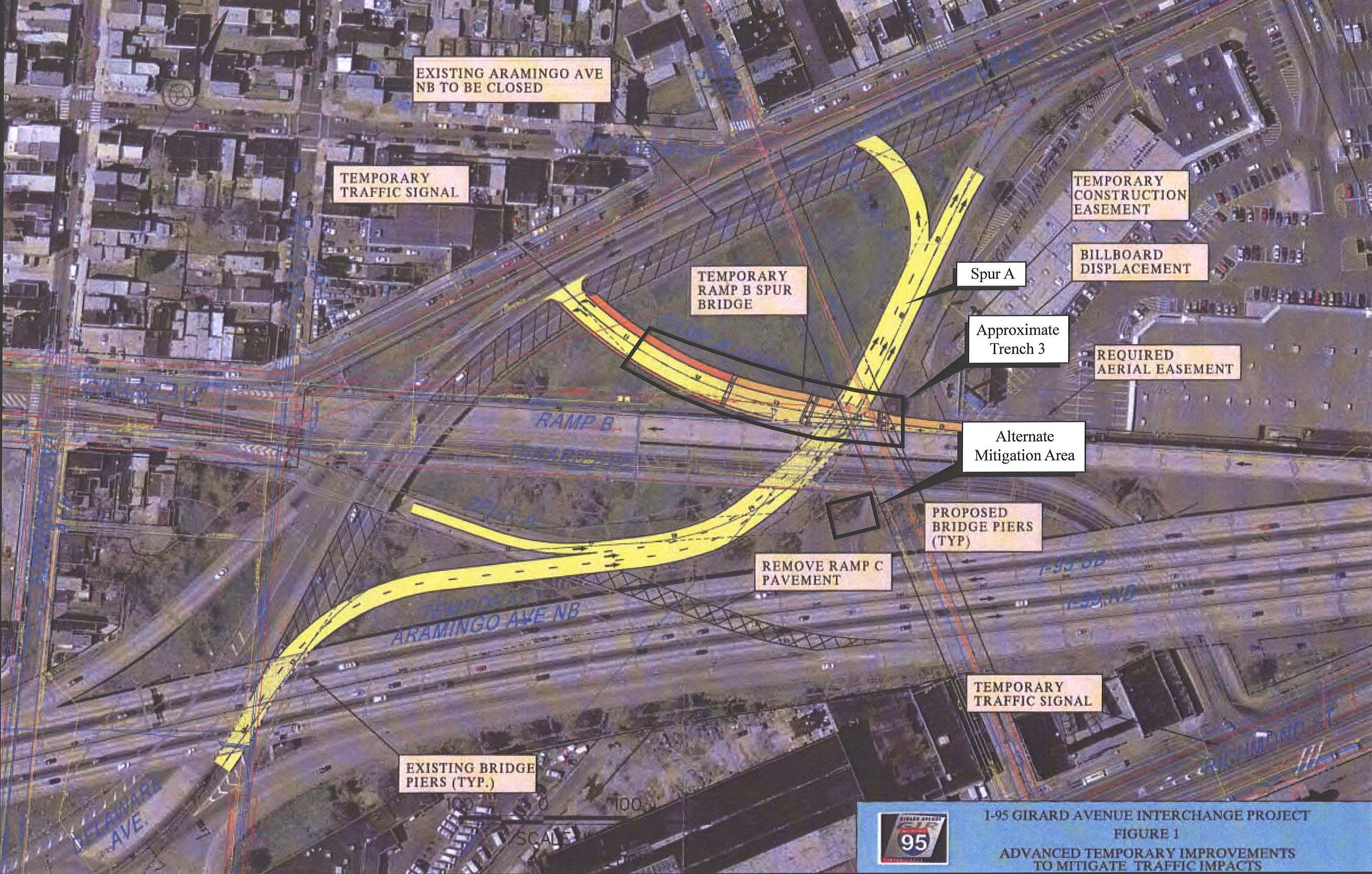
This report volume covers archaeological studies for the GR0 section of the I-95 Improvement Corridor (I-95/GIR) Project (located within the Girard Avenue Interchange), including investigations of the Aramingo Canal. Results from other archaeological investigations for the I-95/GIR project will be reported in separate volumes. Undisturbed components of the Aramingo Canal (circa 1847–1902) were initially identified in September 2007 during archaeological testing of a planned temporary traffic ramp (Ramp B Spur) in the GR0 section (Figure 1.2). The testing covered all areas of potential ground disturbance for this section of the project. The findings of this work, as well as a synopsis of the canal’s known history and recommendations for alternative mitigation measures, were previously documented in a letter report 1 submitted to PennDOT District 6-0 and the BHP. Provisional concurrence with those findings and recommendations were received from PennDOT and BHP on October 30, 2007, pending the review and acceptance of the data-recovery work plan. Concurrence with the work plan was provided by the BHP on March 6, 2008 (Appendix C).
Chapter 2 of this volume provides the results of detailed background research on the history of the canal and nearby communities. Chapter 3 discusses the results of the Phase IB/II survey for Section GR0. Chapter 4 presents the results of the Phase III data-recovery fieldwork and laboratory analysis for the Aramingo Canal itself. The data is synthesized in Chapter 5 and used to address the research issues developed for the investigations. The research design, including the research issues that guided the field investigations and the field and laboratory methods, are detailed in Appendix D.
Project Description
The GR0 portion of the larger I-95 project falls within areas designated as Section 6 in the Phase IA archaeological sensitivity study 2 and encompasses the locations of a series of advance temporary roadway improvements required to mitigate future construction-related traffic impacts. Most planned improvements in this area involved only minor modifications to existing roads and overpasses, or the construction of temporary road spurs atop compacted fill, and therefore were judged unlikely to impact any potential archaeological resources. However, the construction of one new temporary road segment—called the Ramp B Spur and intended to connect Aramingo Avenue and the existing Ramp B elevated roadway—did have the potential to impact archaeological resources and required that subsurface testing be performed in advance of construction.
In this instance, subsurface impacts were confined to those specific locations where steel pilings and associated concrete pile caps were to be installed to support the temporary Ramp B Spur elevated roadway. In total, pilings were planned for installation in association with the construction of a single concrete abutment and four vertical support piers. All of these support structures were situated directly north of the existing Ramp B roadway, with the abutment and Pier 1 located west of the existing Spur A (Delaware Avenue to Aramingo Avenue) roadway, and Piers 2–4 to the east of Spur A.
Construction of the abutment and support piers involved the installation of a series of steel pilings in each of the above locations, with each piling driven into the underlying bedrock. Pile caps were to be constructed at the top of each piling to support associated vertical structural members. Pile caps ranged in size from 13 x 19 feet to 27 x 37 feet in total area, and extended into the ground to a depth of approximately 4 to 5 feet below ground surface.
The study area extended both east and west of the Spur A roadway. The western portions of the study area fell within a large open, grassy field that formerly contained the eastern terminus of Girard Avenue and a series of mid- to late-nineteenth-century commercial/industrial buildings. To the east of Spur A, the study area traverses what had historically been the meandering streambed of Gunner’s Run, and subsequently became the channel of the Aramingo Canal. The canal originally cut through this eastern area from northeast to southwest and measured approximately 100 feet across. Proposed Piers 2, 3, and 4 were determined to fall either directly within portions of the Aramingo Canal prism or areas immediately adjacent to it.
Subsequent Phase III data-recovery excavations, designed to more thoroughly study the canal’s construction and use, were conducted in an approved alternate mitigation area located outside the GR0 study area, but still within the larger Girard Avenue Interchange. The alternate mitigation area was situated in an open grassy space immediately to the south of the current Girard Avenue ramp, and to the north of the elevated northbound I-95 roadway. The alternate mitigation location will not be impacted during planned I-95 construction activities, but was situated in a space that permitted a large section of the canal to be excavated and documented.
Project Personnel
Douglas Mooney served as Principal Investigator for the project. Anthony McNichol and Jeffrey Harbison directed the field crew, which included Lisa Geiger, Christy Wallover, Alex Agran, and Alex Devries. Christy Wallover conducted the laboratory analysis with assistance from Mara Kaktins. Paul Elwork edited the report for style and consistency. Scott Hood produced the report graphics and Anthony McNichol illustrated the hand-drawn profiles.